Loading...

❄️ WINTER SALE! 50% OFF on Supporter Accounts — now through January 31st. Unlock a full year of exclusive website & app perks. Learn More.

Loudoun Heights (Split Rock) Hike

With Maryland Heights and C&O Canal/Weverton Cliff, this is one of three beautiful vista hikes that start in the Harpers Ferry area. Significantly less crowded than the other two hikes, the Loudoun Heights hike also has several beautiful views of the Potomac River and Harpers Ferry.

The first 1 mile is also steeped with history, climbing a flight of steps hand hewn in the 1800's, passing St. Peters Roman Catholic Church, the ruins of St John's Episcopal Church, Jefferson Rock, and Harper Cemetery. All before reaching the secondary parking area where the hike crosses the US340 bridge and Shenandoah River.

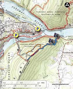
  • Mile 0.0 – From the parking area at the Harpers Ferry train station, walk a short distance down Potomac Street, then make the right up Hog Alley. At the top of Hog Alley turn left, then in 50 yards turn right up the hand-hewn steps that lead to the most prominent landmark in Harpers Ferry, St. Peters Roman Catholic Church. The church was completed in 1833 to accommodate the influx of Irish laborers that supported the construction of the C&O Canal. During the Civil War Father Costello flew the British Union Jack to symbolize the church's neutrality, which sustained minimal damage during the war. The church was remodeled in 1869 to today's appearance.
  • Mile 0.2 - Now follow the white blazes of the Appalachian Trail (A.T.) passing the ruins of St. Johns Episcopal Church on the right. This church was used as a hospital and barracks during the Civil War, and sustained considerable damage. The church was abandoned in 1895 when a new church was built in the upper town. From St. John's continue a short distance to Jefferson Rock on the A.T.
  • Mile 0.3 - In 1733 Thomas Jefferson on visiting this spot proclaimed: "On your right comes up the Shenandoah, having ranged along the foot of the mountain a hundred miles to seek a vent. On your left approaches the Patowmac [Potomac], in quest of a passage also. In the moment of their junction they rush together against the mountain, rend it asunder, and pass off to the sea ... This scene is worth a voyage across the Atlantic." Around 1860, the US Armory Superintendant ordered red sandstone supports placed under Jefferson Rock because it was "endangering the lives and properties of the villagers below." From Jefferson Rock it is a short distance along the A.T. to Harper Cemetery. The 4-acre cemetery was set aside by John Harper, a Pennsylvania architect who passed through the area in 1747 then settled there, founding Harpers Ferry. Continue along the A.T passing a turn off to the Appalachian Trail Visitors Center on the right, then stay right on the A.T. where the trail splits, and continue to US340.
  • Mile 1.1 - Pass above the secondary parking area on the A.T., crossing the Shenandoah River on US340. At the opposite end of the bridge the A.T. descends down and under the bridge, then begins its ascent of Loudoun Heights. As the A.T. climbs the mountain pass over a small creek that can run nicely in the Springtime.
  • Mile 2.3 - After ascending for 0.5 miles cross Chestnut Hill Road. From Chestnut Hill Rd. it's 0.3 miles to the intersection of the orange blazed trail. Turn left on the orange blazed trail as it climbs to the ridge.
  • Mile 2.8 - Turn left on the blue blazed Loudoun Heights Trail north passing a view of the Potomac River at a power line clear-cut. The trail then descends to the right and passes around the mountain.
  • Mile 3.8 - Arrive at Loudoun Heights Overlook / Split Rock where the Loudoun Heights Trail ends. The overlook has beautiful views of Harpers Ferry and Maryland Heights. Now start your return by retracing your steps uphill back to the orange blazed trail intersection.
  • Mile 7.6 - Retrace your route to return. Arrive back a the train station parking area.
Explore 33 trails near Harpers Ferry, WV

Know Before You Go

  • The Loudoun Heights (Split Rock) hike offers stunning, less crowded vistas of Harpers Ferry and the Potomac River compared to Maryland Heights and C&O Canal/Weverton Cliff trails.
  • The first mile of the hike is historically rich, featuring landmarks like St. Peters Roman Catholic Church, St. John's Episcopal Church ruins, Jefferson Rock, and Harper Cemetery.
  • The 7.6-mile hike involves a climb up Loudoun Heights, crossing the Shenandoah River via the US340 bridge, and following a combination of white, orange, and blue blazed trails to reach the Loudoun Heights Overlook/Split Rock.
Interactive topographic map for Loudoun Heights (Split Rock) Hike located in Harpers Ferry, WV. Click the "View Map" button to load GPS coordinates and trail markers.
Get directions
Distance
7.6 mi
Difficulty
Moderate
Type
Out-and-Back
Est. Time
3.8 hrs
Elev. Gain
2,051'
Rating
3.7
Added
March 20, 2025
Updated
April 06, 2025

Weather Forecast

Tonight
Low 41°F
Mostly Cloudy
Wednesday
High 48°F
Light Rain Likely
Wednesday Night
Low 22°F
Rain And Snow Likely
Thursday
High 27°F
Slight Chance Light Snow then Mostly Sunny
Thursday Night
Low 16°F
Mostly Clear
Friday
High 33°F
Mostly Sunny
Friday Night
Low 25°F
Partly Cloudy
Saturday
High 41°F
Mostly Sunny then Slight Chance Light Snow
Saturday Night
Low 21°F
Slight Chance Light Snow then Mostly Cloudy
Sunday
High 28°F
Mostly Sunny
Sunday Night
Low 16°F
Partly Cloudy
M.L. King Jr. Day
High 31°F
Mostly Sunny
Monday Night
Low 15°F
Partly Cloudy
Tuesday
High 25°F
Mostly Sunny
Loading...
Total Change
802'
Ascent
2,051'
Descent
2,054'
Loading...

Download the GPX Data for Offline Use

Supporters get exclusive access to download trail routes to the MyHikes app for offline use. Stay prepared on your adventure, even without an internet connection! Become a Supporter today to unlock this feature and hike with confidence.

Download Loudoun Heights (Split Rock) Hike GPX Data to the MyHikes Mobile App

Features

Vista / Lookout Point
Dogs
Water Source
Appalachian Trail logo Appalachian Trail hike

Points of interest

  1. Parking

    39.324167, -77.730967
  2. Main Trailhead

    39.323874, -77.730503

Safety information

For your own safety: plan ahead, let someone know where you'll be, and hike at your own risk.

Hazards

Snakes (Rattlesnakes, Copperheads, others)
Poison Ivy or Poison Oak

Availability

All seasons

Surface type

Dirt

Trip Reports (Reviews)

Rated 3.67 out of 5 based on 6 ratings.

Ready to help fellow hikers? Add a trip report to share your experience and provide valuable insights for other hikers!

By: Daniela
7.6 miles / 12.2 km
October 04, 2019
I hiked this on 10/4/19 and apparently some changes have been made recently. The blue trail from the AT to the orange trail is blocked off with branches and the AT has been rerouted to the west of where it originally was from where it crosses from VA into WV to a little before the orange trail. I did go through the branches and take the blue trail back to the AT after heading back from the overlook. At this time it is still clear and blazed. Strange that it appears they are doing away with that section. I could find nothing wrong with it and it is definitely a much easier route than orange.
Legacy Review
By: Alan
7.6 miles / 12.2 km
November 10, 2018
Not a regular hiker, but figured NPS would have a nice hike for visitors. Was wrong. Am in shape, could have finished hike. Dropped leaves completely obliterated trail. Had to rely on markers. These markers are woefully inadequate! Found trees with white blazes toppled over. Mid way up we found orange ribbons around trees, was this the orange trail? No it wasn’t. Lost time there. Why were they there? White blazes ran out about mid way up mountain. My wife and I stood for 30 minutes in vain trying to find next white blaze. Was thinking couldn’t a park service employee walk the trail twice a year with 3 cans of orange, white and blue spray paint to mark the trail so that visitors can EASILY see the path? I would pay for the paint! Returned to the hotel with thought that a little foresight and work by NPS, a lot more people can enjoy this mountain. Poorly marked trail ruined it for casual hiker tourists. Don’t recommend the hike till they do the necessary markings. You will become lost.
Legacy Review
By: Peter
7.6 miles / 12.2 km
November 10, 2018
Alan's review is woefully bad. I hiked Loudoun heights on Saturday as well, from Harpers Cemetery. There is nothing difficult about navigating this hike: you can hike the white blazed AT halfway up the mountain, and take the orange trail to the blue trail after going up a huge hill at the end of the orange trail. Or you can hike the white blaze to the top and turn left on the blue trail off of the white trail, which is easier in the long run because the grade lessens greatly after the orange trail and once you get to the blue it's flat or going downhill. I saw a lot of people struggling with this trail today. If you can't hike the upper Maryland heights trail, you wont be able to hike this one. As for the condition of this trail, it was fine and navigable. Trees were knocked down because the wind was blowing 40-45 mph at times. If you hike, you will find fallen trees. Its common. It was hard to stay at the overlook on Saturday with that big wind. Anyway, long story short, this is an easy hike to do if you are fit and observe your surroundings. Ive helped several people get back on the trail, after getting off because the simply were talking and not paying attention to whats going on around them. Lastly, it's fall and there are leaves everywhere. These are trails. They arent vaccumed by Harpers Ferry NPS.
Legacy Review
No community routes found. To add your own hike as a Community Route for this Trail guide, leave a Trip Report with an attached GPX file.

Popular categories

Scenic mountain view representing vista trails
Vista trails
Scenic gorge of cascades representing waterfall trails
Waterfall hikes
Rugged mountain terrain representing summit trails
Summit trails
Scenic mountain view representing dog-friendly trails
Dog-friendly
Scenic campsite with a view representing camping trails
Camping trails
Appalachian Trail logo representing A.T. hikes
A.T. hikes

You May Also Like

Colorado's Million Dollar Highway - Plan a day's drive adventure along the iconic Million Dollar Highway in Colorado. Explore the best short trails, roadside stops, waterfalls, vistas, ghost towns, and hot springs within a ~6 hour road trip.
Explore

Colorado's Million Dollar Highway

Plan a day's drive adventure along the iconic Million Dollar Highway in Colorado. Explore the best short trails, roadside stops, waterfalls, vistas, ghost towns, and hot springs within a ~6 hour road trip.

Read
🍪 We use cookies to learn about site usage and to serve map tiles. You may block cookies manually in the browser. By continuing you agree. Learn more