The Lost Run Overlook at the Quehanna Wild Area near Frenchville, Pennsylvania is an easy 0.1-mile out-and-back trail that leads to a boulder field formation along a mountain side high above Mosquito Creek that features views of the surrounding mountains.
This trail technically lies within the State Game Lands #34 area within the Quehanna Wild Area so hikers should be warned to wear orange clothing when visiting. Also note that this vista is unofficially named, but located off of Lost Run Road, hence the name given on this page.
The trail begin at the small parking lot and heads in for about 20-feet before taking a right-hand turn along a dirt path that leads through the woods and over to the large boulders near the vista. Hikers should walk around to the south of these boulders to reach the main vista.
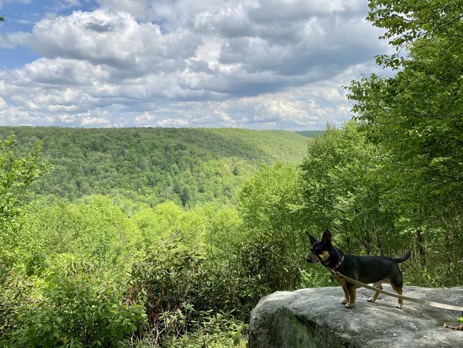
Climb up the large boulder and enjoy the vista of the mountains above Mosquito Creek within the Quehanna Wild Area.
As of May 2020, there was a plaque setup and dedicated to a man named Chris Retchberger who passed away in May 2018. While this vista has no official name, the folks who put up this plaque may have dubbed it the "Retchberger Vista", but this is speculation.
Warning
Hikers should also note that this trail has a ton of poison ivy from the parking lot all the way toward the boulders. Do not touch your boots and then touch your skin afterward. Also, the climb to reach the vista is about 5-feet up a large boulder, which may be unsafe for younger children. Last, the Timber Rattlesnake likes to live within boulder fields and while these boulders are massive, it's best to keep an eye out for any poisonous snakes.
Pets
Dogs are allowed if leashed.
Parking
Hikers can find a small parking turnout at the coordinates provided.
This trail technically lies within the State Game Lands #34 area within the Quehanna Wild Area so hikers should be warned to wear orange clothing when visiting. Also note that this vista is unofficially named, but located off of Lost Run Road, hence the name given on this page.
The trail begin at the small parking lot and heads in for about 20-feet before taking a right-hand turn along a dirt path that leads through the woods and over to the large boulders near the vista. Hikers should walk around to the south of these boulders to reach the main vista.
Climb up the large boulder and enjoy the vista of the mountains above Mosquito Creek within the Quehanna Wild Area.
As of May 2020, there was a plaque setup and dedicated to a man named Chris Retchberger who passed away in May 2018. While this vista has no official name, the folks who put up this plaque may have dubbed it the "Retchberger Vista", but this is speculation.
Warning
Hikers should also note that this trail has a ton of poison ivy from the parking lot all the way toward the boulders. Do not touch your boots and then touch your skin afterward. Also, the climb to reach the vista is about 5-feet up a large boulder, which may be unsafe for younger children. Last, the Timber Rattlesnake likes to live within boulder fields and while these boulders are massive, it's best to keep an eye out for any poisonous snakes.
Pets
Dogs are allowed if leashed.
Parking
Hikers can find a small parking turnout at the coordinates provided.