Loading...

❄️ WINTER SALE! 50% OFF on Supporter Accounts — now through January 31st. Unlock a full year of exclusive website & app perks. Learn More.

Losey Vista

Directions
Map
Pictures
Download Losey Vista GPX Data to the MyHikes Mobile App
Distance:
0.1 Miles / 0.2 km
Type:
Out-and-Back
Difficulty:
Easy
Time to Hike:
~5 minutes
Features:
PA Wilds
Surface Type:
Dirt
Park:
Susquehannock State Forest
Town:
Ulysses, Pennsylvania
Get Directions:
41.76013, -77.751014
Added:
April 24, 2023
Updated:
April 24, 2023
Copy Trail Link Hiking this trail? Send a friend or family member a link to this trail guide for your own safety. Hike at your own risk (disclaimer)
Loading...
Loading...
5'

Total Change
5'

Ascent
5'

Descent

Download the GPX Data for Offline Use

Supporters get exclusive access to download trail routes to the MyHikes app for offline use. Stay prepared on your adventure, even without an internet connection! Become a Supporter today to unlock this feature and hike with confidence.

Download Losey Vista GPX Data to the MyHikes Mobile App

Know Before You Go

  • Losey Vista offers easily accessible mountain views in Susquehannock State Forest, PA, requiring minimal to no walking.
  • The vista point is a roadside turnout with parking for a few vehicles, suitable for enjoying the PA Wilds without hiking.
  • Accessibility is limited in winter due to lack of maintenance on forest roads; leashed dogs are permitted.

Losey Vista

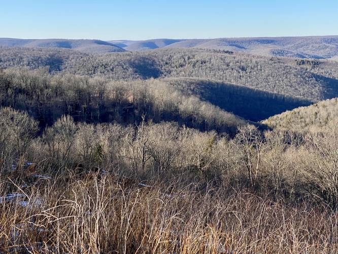
Losey Vista at Susquehannock State Forest in Ulysses, Pennsylvania is an accessible roadside north-facing view of the mountainous plateau surrounding PA-6.

This is not a hike and just barely a walk, but rather a few steps out of your car to take in the views of the mountains at the Losey Vista. This is a great spot for folks to enjoy the mountains of the PA Wilds without having to do any hiking or really any walking if they choose not to or physically can't. If you choose the walk, the distance is negligible, but there are different vantage points from each end of the parking turnout.

Parking
Visitors will find parking at the coordinates provided. The turnout is large enough to fit a half-dozen vehicles at most.

Pets
Dogs are allowed if leashed and cleaned up after.

No Winter Maintenance
There's no Winter maintenance on these forest roads, so don't expect to be able to reach this vista unless on a snowmobile (if permitted on this road).
Explore 245 trails near Ulysses, PA
  1. Parking

    41.76013, -77.751014
  2. Main Trailhead

    41.76012, -77.75107
  3. Mountain view at the Losey Vista

    41.760303, -77.750983
    Mountain view at the Losey Vista
No community routes found. To add your own hike as a Community Route for this Trail guide, leave a Trip Report with an attached GPX file.

Hazards

Ticks - Lyme Disease More Info (CDC)

Seasons

Spring, Summer, Fall

Trip Reports (Reviews)

Ready to help fellow hikers? Add a trip report to share your experience and provide valuable insights for those planning their next hike. Your review makes the trail better for everyone.

Your opinion matters! Be the first to rate this trail.
0.1 miles / 0.2 km
February 20, 2023
Hiking

Weather Forecast

In Ulysses, PA

Explore Hiking Trails

You May Also Like

New York's Best Waterfalls - Whether you're planning a day hike, roadside stop, or a leisurely short walk, this guide provides hikers, travelers, and locals alike with 63 different locations to over 100 scenic waterfalls to help plan your next adventure!
Explore

New York's Best Waterfalls

Whether you're planning a day hike, roadside stop, or a leisurely short walk, this guide provides hikers, travelers, and locals alike with 63 different locations to over 100 scenic waterfalls to help plan your next adventure!

Read

Before you boogie...

Find our trail guides useful? Consider becoming a Supporter to unlock perks!

MyHikes is an indie platform that makes exploring public trails easier for everyone. The platform has no investors, no ads, and is owned and operated by one person, Dave Miller. Dave has personally mapped and written over 1,900 trail guides on MyHikes for the public to explore. MyHikes has helped millions outdoor enthusiasts plan their next adventure.

But it takes a lot of time 🕦, money 💰, work, and espresso shots ☕ to run MyHikes, including hiking , mapping , writing , and publishing new trails with high-quality (accurate) information... along with software engineering (coding) the platform like building new features, website and mobile app development (iOS and Android), site maintainance . and much much more.

Supporters unlock website and mobile app perks with an annual one-time payment of $25 (you renew) 😎👍. Or you can simply make a Donation of your choice. Otherwise, you can support us by telling your friends about MyHikes - both quick and free 🎉

Admin avatar

Dave Miller
MyHikes Founder
🍪 We use cookies to learn about site usage, performance, and to serve map tiles. You may block cookies manually in the browser. By continuing to use MyHikes, you agree. Learn more