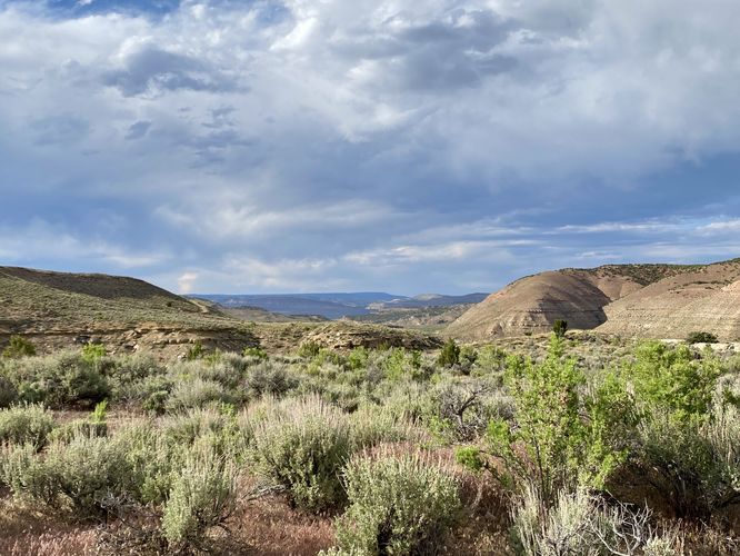
The Lookout Point Interpretive Site Trail at Canyon Pintado National Historical District near Rangely, Colorado is a moderate 0.5-mile out-and-back hike that features an ancient Fremont structure and views of Canyon Pintado.
Hike
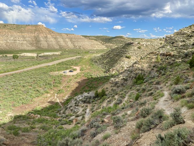
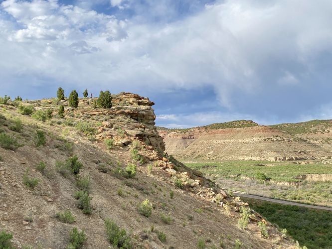
This short hike begins at the dirt parking lot, nestled away just off of CO-139 south of Rangely at the coordinates provided. The trail can be found on the northwest side of the parking lot where you'll find a small trailhead sign. The skinny pathway leads toward the edge of the mesa before it starts heading up switchbacks to climb the hill. The trail is easy to follow, but has several hazardous sections where the trail sits on-top of larger rocks that appear to be slowly slipping down the hill, as of June 2024. The trail is fairly skinny as it runs up the switchbacks, so watch your step.
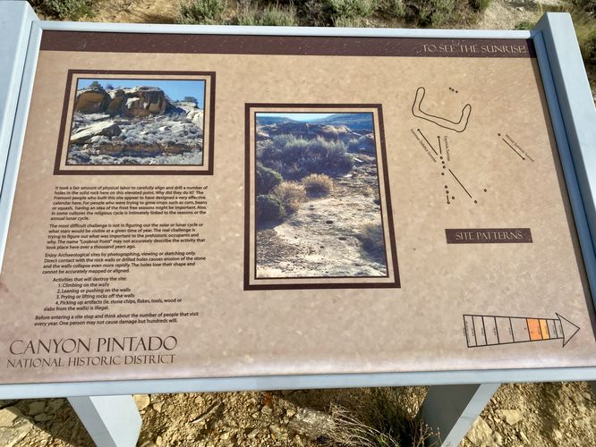
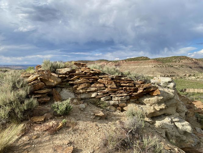
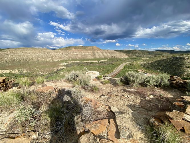
The trail then curves around a cliff area with a slight rock overhang before it leads uphill as it passes through a flatter area with north, east, and south-facing views. The trail then bends to the south, heading downhill slightly, to reach an interpretive sign about ancient the Fremont architecture located on the edge of the cliff. There are also drill holes that the ancient Fremont people used as a calendar which aided in helping them understand when to grow certain crops based on frosts. If you follow the trail out to the edge of the cliff, you'll find a nice view of the Canyon Pintado where you just hiked up from. Sitting just on the edge of the most-dangerous part of the cliff is the ancient Fremont structure. Do not climb on or disturb the structure to ensure it stays intact for future generations to enjoy.
After taking in the views and exploring the ancient structure and drill holes, the trail then leads back to parking for a short 0.5-mile out-and-back hike.
Parking
Hikers will find a dirt parking lot located off of CO-139 at the coordinates provided. The lot is large enough to fit about 1-dozen vehicles as of June 2024.
Pets
Dogs are allowed only if leashed and must be cleaned up after.
Warnings
Sun exposure: This trail has very little shade and no water sources. Pack-in all water and wear sun screen and a hat to protect against sun exposure. It's smart to hike either in the early morning or late afternoon to avoid the intense sun.
No water: This trail has no water sources so you must pack-in all water. A general rule of thumb in the desert is 1 gallon of water per person per day.
Rattlesnakes: This trail leads through rattlesnake territory, so be on the lookout and give any rattlers you find plenty of space.
Rockfall: This trail passes under a rock cliff that can occasionally have rockfall activity.
Hike
This short hike begins at the dirt parking lot, nestled away just off of CO-139 south of Rangely at the coordinates provided. The trail can be found on the northwest side of the parking lot where you'll find a small trailhead sign. The skinny pathway leads toward the edge of the mesa before it starts heading up switchbacks to climb the hill. The trail is easy to follow, but has several hazardous sections where the trail sits on-top of larger rocks that appear to be slowly slipping down the hill, as of June 2024. The trail is fairly skinny as it runs up the switchbacks, so watch your step.
The trail then curves around a cliff area with a slight rock overhang before it leads uphill as it passes through a flatter area with north, east, and south-facing views. The trail then bends to the south, heading downhill slightly, to reach an interpretive sign about ancient the Fremont architecture located on the edge of the cliff. There are also drill holes that the ancient Fremont people used as a calendar which aided in helping them understand when to grow certain crops based on frosts. If you follow the trail out to the edge of the cliff, you'll find a nice view of the Canyon Pintado where you just hiked up from. Sitting just on the edge of the most-dangerous part of the cliff is the ancient Fremont structure. Do not climb on or disturb the structure to ensure it stays intact for future generations to enjoy.
After taking in the views and exploring the ancient structure and drill holes, the trail then leads back to parking for a short 0.5-mile out-and-back hike.
Parking
Hikers will find a dirt parking lot located off of CO-139 at the coordinates provided. The lot is large enough to fit about 1-dozen vehicles as of June 2024.
Pets
Dogs are allowed only if leashed and must be cleaned up after.
Warnings
Sun exposure: This trail has very little shade and no water sources. Pack-in all water and wear sun screen and a hat to protect against sun exposure. It's smart to hike either in the early morning or late afternoon to avoid the intense sun.
No water: This trail has no water sources so you must pack-in all water. A general rule of thumb in the desert is 1 gallon of water per person per day.
Rattlesnakes: This trail leads through rattlesnake territory, so be on the lookout and give any rattlers you find plenty of space.
Rockfall: This trail passes under a rock cliff that can occasionally have rockfall activity.