Loading...

Distance:
0.1 Miles / 0.2 km
Type:
Out-and-Back
Difficulty:
Easy
Time to Hike:
~5 minutes
Features:
PA Wilds
Surface Type:
Dirt
Park:
Tiadaghton State Forest
Town:
Carsontown, Pennsylvania
Directions:
41.418618, -77.368829
Added:
January 22, 2023
Updated:
January 22, 2023
Loading...
Loading...
12 '

Total Change
12 '

Ascent
10 '

Descent

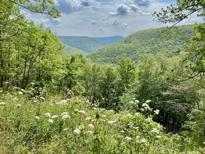
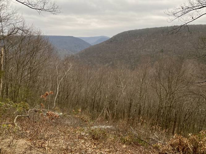
Longs Ridge Vista at Tiadaghton State Forest near Carsontown, Pennsylvania is a roadside vista that provides views of the mountains surrounding Little Pine State Park.

This is not a hike nor a walk but rather a quick stop along a dead-end dirt forest road to a vista point along the mountainside of Longs Ridge. Visitors will find a one-lane dirt road that skirts a very steep mountainside that runs the mountain ridge out to this vista. Folks not used to this type of driving may want to avoid this one.

Parking
There's a small parking turnout near the vista, large enough for a couple of cars to turn around. Note that there's at least one turnout along the one-lane forest road that leads down to the view.

Explore 257 trails near Carsontown, PA
  1. Parking

    41.418618, -77.368829
  2. Main Trailhead

    41.418685, -77.368897
  3. Longs Ridge Vista

    41.418694, -77.368661
    Longs Ridge Vista
No community routes found. To add your own hike as a Community Route for this Trail guide, leave a Trip Report with an attached GPX file.

Hazards

Ticks - Lyme Disease More Info (CDC)
Snakes

Seasons

All

Photo Albums

4 Trip Reports

No Star-Ratings
Write-up by:
Admin user profile picture
0.1 miles / 0.2 km
Trail added
January 22, 2023
Hiked on
July 16, 2022
Updated on
January 22, 2023
0.1 miles / 0.2 km
January 23, 2023
2nd time here, first was in July 2022 though Trail reflects Jan 2023.
Dogs Hiking
0.1 miles / 0.2 km
January 23, 2023
Dogs Hiking
0.1 miles / 0.2 km
July 16, 2022
Dogs Hiking

Weather Forecast

In Carsontown, PA

Explore Hiking Trails

New Hikes

Lower Ammonoosuc Falls Trail
1.1 Miles
1.8 km
Easy
Out-and-Back
Bates Ferry Trail and General Greene Tree
2.7 Miles
4.3 km
Easy
Out-and-Back
Sewee Shell Ring Trail
1.1 Miles
1.8 km
Easy
Loop
Cottonwood Falls Loop
1.2 Miles
1.9 km
Moderate
Loop

Before you leave...

MyHikes is an indie web platform aimed to make exploring public trails easier for everyone. The site has no investors and is owned and operated by one person, Dave Miller (Founder & Admin). As the Founder, main contributor, and doer-of-all-things for MyHikes, I share my trips with over-detailed write-ups for fun on a volunteer basis and I believe that public trail information should be available to everyone.

It takes a lot of time 🕦, money 💰, and effort (including espresso shots ☕) to run MyHikes, including hiking , mapping , writing , and publishing new trails with high-quality content... along with building new features, moderating, site maintainance, and app development for iOS and Android . I simply ask that if you find MyHikes' trail guides helpful to please consider becoming a Supporter to help keep the site, iOS, and Android apps available to everyone.

Supporters unlock website and in-app perks with a one-time payment of $25 (you renew) 😎👍. Or you can simply make a Donation of your choice without a MyHikes user account. Otherwise, telling your friends about MyHikes is the next-best thing - both quick and free 🎉

Thanks for visiting MyHikes and have a great hike!️

Admin user profile picture

Dave Miller
MyHikes Founder & Admin