Loading...

WINTER SALE! 50% OFF Supporter Accounts — now through January 31st. Learn More.

Long Mountain - M & M Trail

The Long Mountain Trail at the Mount Holyoke Range State Park in Granby, MA, is a moderate 2 mile out-and-back hike from Mt Harris Rd up to the summit of Long Mountain.

Follow the M & M trail (white blazes) from the parking lot. The hike is uphill almost throughout the entire hike. Just before the last climb to the summit of Long Mountain, the trail climbs a steep set of stairs, which can be iced over during the winter or slippery after a rainfall, so watch your step.

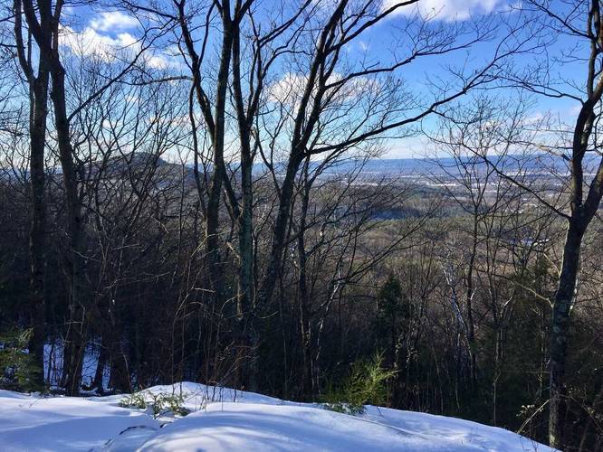
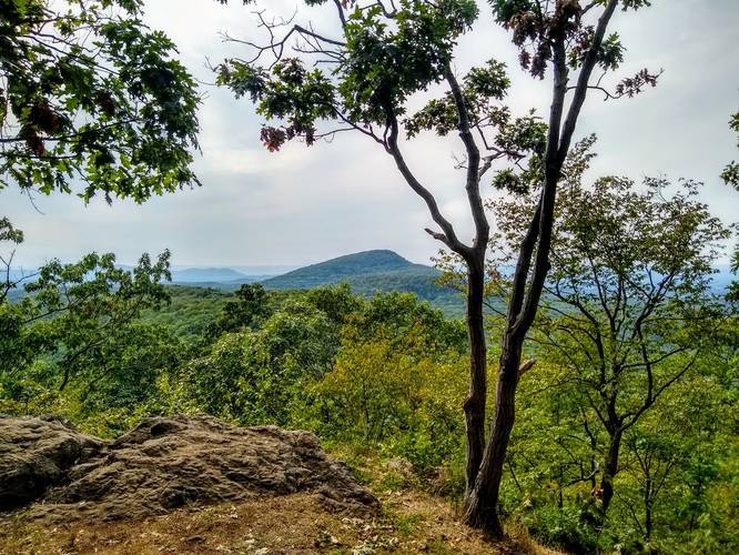
The lookout is on the far end which leads on to the notch visitors center. The lookout is not cut out from the trees very well, so you get better views during the colder months when the leaves aren't on the trees.
Explore 210 trails near Granby, MA

Know Before You Go

  • The Long Mountain Trail is a 2-mile moderate out-and-back hike on the M & M trail (white blazes) in Granby, MA, within the Mount Holyoke Range State Park.
  • The trail is primarily uphill, featuring a steep set of stairs near the summit that can be hazardous in icy or wet conditions.
  • The summit lookout point has limited views due to trees, with better visibility during colder months when the leaves have fallen.
Interactive topographic map for Long Mountain - M & M Trail located in Granby, MA. Click the "View Map" button to load GPS coordinates and trail markers.
Get directions
Distance
2.0 mi
Difficulty
Moderate
Type
Out-and-Back
Est. Time
1 hrs
Elev. Gain
599'
Rating
0.0
Added
October 31, 2016
Updated
June 17, 2018

Weather Forecast

Today
High 21°F
Partly Sunny then Slight Chance Snow Showers
Tonight
Low -1°F
Partly Cloudy
Wednesday
High 23°F
Mostly Sunny
Wednesday Night
Low 1°F
Mostly Cloudy
Thursday
High 21°F
Mostly Sunny
Thursday Night
Low -2°F
Mostly Clear
Friday
High 16°F
Sunny
Friday Night
Low -7°F
Mostly Clear
Saturday
High 23°F
Mostly Sunny
Saturday Night
Low 6°F
Chance Light Snow
Sunday
High 27°F
Chance Light Snow
Sunday Night
Low 12°F
Chance Light Snow
Monday
High 31°F
Mostly Sunny
Monday Night
Low 10°F
Partly Cloudy
Loading...
Total Change
549'
Ascent
599'
Descent
623'
Loading...

Download the GPX Data for Offline Use

Supporters get exclusive access to download trail routes to the MyHikes app for offline use. Stay prepared on your adventure, even without an internet connection! Become a Supporter today to unlock this feature and hike with confidence.

Download Long Mountain - M & M Trail GPX Data to the MyHikes Mobile App

Features

Dogs
Mountain Summit

Points of interest

  1. Parking

    42.307549, -72.470772
  2. Main Trailhead

    42.30757, -72.470844

Safety information

For your own safety: plan ahead, let someone know where you'll be, and hike at your own risk.

Markers

Blaze Color

White

Availability

Fall

Surface type

Dirt

Trip Reports (Reviews)

Your opinion matters! Be the first to rate this trail.

Ready to help fellow hikers? Add a trip report to share your experience and provide valuable insights for other hikers!

2.9 miles / 4.7 km
September 09, 2020
Great trail. Moderately challenging with one amazing view at the summit. This hike is a great option if you want to avoid more crowded trails. I made it a loop, descending a more gradual way. The only downside to this trail is it has to be the buggiest spot in the whole Holyoke Range. Didn't matter that I was wearing 40% Deet.
Hiking
2.0 miles / 3.2 km
May 07, 2019
2.0 miles / 3.2 km
December 26, 2017
Hiked Long Mountain from the Mt Harris Rd parking lot the day after Christmas 2017 with about 4 - 6 inches of snow. The trail was empty but we did pass one other person as we hiked back down the mountain. The last leg of the hike shoots up the side of Long Mountain with stairs that make this section a bit easier. Hiking in the winter can be slippery so ice spikes can be helpful. There are more views in the winter through the trees as well.
Hiking

Explore other routes for this Trail guide, added by the MyHikes' community via Trip Reports (Reviews). To add your own hike as a Community Route for this Trail guide, leave a Trip Report and attached your GPX file!

Popular categories

Scenic mountain view representing vista trails
Vista trails
Scenic gorge of cascades representing waterfall trails
Waterfall hikes
Rugged mountain terrain representing summit trails
Summit trails
Scenic mountain view representing dog-friendly trails
Dog-friendly
Scenic campsite with a view representing camping trails
Camping trails
Appalachian Trail logo representing A.T. hikes
A.T. hikes

You May Also Like

Colorado's Million Dollar Highway - Plan a day's drive adventure along the iconic Million Dollar Highway in Colorado. Explore the best short trails, roadside stops, waterfalls, vistas, ghost towns, and hot springs within a ~6 hour road trip.
Explore

Colorado's Million Dollar Highway

Plan a day's drive adventure along the iconic Million Dollar Highway in Colorado. Explore the best short trails, roadside stops, waterfalls, vistas, ghost towns, and hot springs within a ~6 hour road trip.

Read
Glacier's Going-to-the-Sun Road - Discover the breathtaking beauty of Glacier National Park along the iconic Going-to-the-Sun Road. From stunning roadside stops to picturesque waterfalls and vistas, this engineering marvel offers endless opportunities for exploration.
Explore

Glacier's Going-to-the-Sun Road

Discover the breathtaking beauty of Glacier National Park along the iconic Going-to-the-Sun Road. From stunning roadside stops to picturesque waterfalls and vistas, this engineering marvel offers endless opportunities for exploration.

Read
🍪 We use cookies to learn about site usage and to serve map tiles. You may block cookies manually in the browser. By continuing you agree. Learn more