Loading...

WINTER SALE! 50% OFF Supporter Accounts — now through January 31st. Learn More.

Long Mountain Hike

The Long Mountain circuit has a 2.0 mile bushwhacking portion that connects the Long Mountain Trail with the Halfmoon Trail in the next valley. With several great campsites, and views, this hike has both solitude and beautiful scenery. If you want to do some bushwhacking, this is a great hike in the spring and fall.

Important Bushwhacking Notes:

  • Only experienced hikers who are comfortable hiking off-trail, using a compass, map, and GPS should do this hike.
  • Sections of the bushwhack have heavy, thorny undergrowth. Wear long pants, or you will feel like you've invited the neighborhood cats over to use your legs as a scratching post by the end of the day.
  • Long Mountain has loose rock covered by a thin layer of leaves making it easy to twist an ankle. Use a hiking stick or poles, and good quality hiking boots for support.
  • Timber Rattlesnakes are extremely hard to detect in the underbrush. Take extreme care.
  • Don't hike this alone. Let someone know where you are hiking, and when you expect to return. If you twist an ankle, or worse, you're on your own out here.

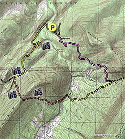
From the Bucktail parking area, walk back down the gravel road to Trout Run Road. On the opposite side of the road is the yellow blazed Long Mountain Trail. Start down the yellow blazed trail and shortly cross a small stream. In 75 yards there is a great campsite on the banks of Trout Run. Also notice the memorial plaque to David J. Opstad, an avid local hiker, attached to the cliff face on the opposite side of the run.

Continue on the yellow blazed trail and shortly cross Trout Run. The trail now heads upward, and in 0.5 miles turns left heading up Cherry Ridge. As the trail makes a right along the spur there are several good view points of Halfmoon Mountain and Trout Run Valley. The trail passes around Cherry Ridge, and will arrive at a large clearing. Turn right remaining on the yellow blazed trail as is descends for another 0.3 miles, then arrives at a four way intersection.

Turn left at the intersection, and in 10 yards turn left again into the dense underbrush and bushwhacking portion of the hike. The map here has the bushwhack marked as dashed light-red, but there is no trail. This is a proposed new trail, and was originally marked with white/blue ribbon in 2005. The ribbon is UV biodegradable and there's no guarantee that it is still there. If you decide this isn't for you, just retrace your route back to the parking area. If you continue, make sure to use the GPS file supplied here.

Climb the mountain for 0.7 miles at 167° mag. using the GPS route, then cross the ridge at a low point at N38 59.287 W78 40.670. The other side of the ridge is very steep on either side of this waypoint.

After crossing the ridge follow the GPS route as it descends the mountain at 87° mag. for 0.2 miles before heading more steeply downhill. Near to the valley floor the route turns more to the north paralleling Trout Run Road, and levels out on an old woods road. Make sure to stay on the uphill side of the GPS route as you will pass close to private property. Cross Trout Run Road at the entrance to the Halfmoon Trail parking area.

Follow the gravel road for 100 yards, pass a closed gate, then cross Trout Run over a small bridge where the yellow blazed Halfmoon Trail begins. Follow the yellow blazed trail (old FS road) as it heads uphill, switches back to the left, then passes through a pine stand. Continue following the trail for 1.3 miles, cross a small stream, and arrive at the junction of the pink blazed Bucktail Connector Trail.

Turn left downhill on the pink trail as it winds around Halfmoon Mountain for 2.5 miles then ends at the orange blazed Bucktail Trail (FS road). Turn left downward on the orange blazed trail for the remaining 0.1 miles back to the parking area.

Explore 66 trails near Wardensville, WV

Know Before You Go

  • The Long Mountain Hike in Wardensville, WV, is an 8.6-mile circuit offering scenic views and solitude, but includes a challenging 2-mile bushwhacking section requiring advanced navigation skills.
  • The bushwhacking portion is unmarked and features dense, thorny undergrowth, loose rocks, and potential hazards like timber rattlesnakes, necessitating proper gear (long pants, hiking boots, hiking stick/poles), navigation tools (compass, map, GPS), and hiking with a companion.
  • The hike combines established trails (Long Mountain Trail, Halfmoon Trail, Bucktail Connector Trail, Bucktail Trail) with the off-trail bushwhacking segment, creating a diverse experience for experienced hikers comfortable with both on-trail and off-trail navigation.
Interactive topographic map for Long Mountain Hike located in Wardensville, WV. Click the "View Map" button to load GPS coordinates and trail markers.
Get directions
Distance
8.6 mi
Difficulty
Strenuous
Type
Loop
Est. Time
4.3 hrs
Elev. Gain
1,946'
Rating
4.2
Added
February 01, 2025
Updated
April 04, 2025

Weather Forecast

This Afternoon
High 17°F
Sleet
Tonight
Low 15°F
Chance Sleet then Mostly Cloudy
Monday
High 22°F
Mostly Sunny
Monday Night
Low -1°F
Mostly Clear
Tuesday
High 27°F
Mostly Sunny
Tuesday Night
Low 3°F
Mostly Cloudy
Wednesday
High 20°F
Mostly Sunny
Wednesday Night
Low 4°F
Mostly Cloudy
Thursday
High 16°F
Mostly Sunny
Thursday Night
Low 0°F
Partly Cloudy
Friday
High 16°F
Mostly Sunny
Friday Night
Low 1°F
Partly Cloudy
Saturday
High 19°F
Mostly Sunny
Saturday Night
Low 4°F
Mostly Clear
Loading...
Total Change
1,063'
Ascent
1,946'
Descent
1,938'
Loading...

Download the GPX Data for Offline Use

Supporters get exclusive access to download trail routes to the MyHikes app for offline use. Stay prepared on your adventure, even without an internet connection! Become a Supporter today to unlock this feature and hike with confidence.

Download Long Mountain Hike GPX Data to the MyHikes Mobile App

Features

Vista / Lookout Point
Dogs
Mountain Summit
Camping

Points of interest

  1. Parking

    39.013488, -78.664577
  2. Main Trailhead

    39.013706, -78.665028

Safety information

For your own safety: plan ahead, let someone know where you'll be, and hike at your own risk.

Hazards

Snakes (Rattlesnakes, Copperheads, others)

Availability

All seasons

Surface type

Dirt

Trip Reports (Reviews)

Rated 4.2 out of 5 based on 5 ratings.

Ready to help fellow hikers? Add a trip report to share your experience and provide valuable insights for other hikers!

By: Your name
8.6 miles / 13.8 km
October 12, 2013
Yes, it is a great campsite across from the gravel parking lot, but no, the memorial plaque for Dave Opstead is not because he was an 'avid local hiker'. In fact, Dave was not from WV and visited the campsite only a few times on an annual camping trip. He was a great guy and made these trips a lot of fun. How do I know? I helped hang the plaque.........
Legacy Review
By: Z-Money
8.6 miles / 13.8 km
March 31, 2013
I did this hike as an overnight (3/30-3/31/13) and it was a very enjoyable experience. The views weren't all that great, but the mountain streams were flowing and I had the mountain to myself. There was still significant snow on some of the mountain tops, so the 2 mile bushwhack portion was very slippery. The trail heads were well marked, except, of course the bushwhacking part. If you have a compass it's not too difficult to find your way, but be careful where you step because it is easy to twist an ankle. This hike was a great workout and over a 24 hour period I didn't see a single person, so it was just what I was looking for. If you are looking for awesome views I would check out some other local hikes. I still recommend this hike as it is a great challenge.
Legacy Review
By: gpshikingdc.com
8.6 miles / 13.8 km
May 23, 2010
When you do this trip, check out the Trout Run Fault Spring - it's to the right of the North-East Corner of the trace. Follow the stream, and then its tributary that leads to the fault spring. That tributary is very pretty.
Legacy Review
No community routes found. To add your own hike as a Community Route for this Trail guide, leave a Trip Report with an attached GPX file.

Popular categories

Scenic mountain view representing vista trails
Vista trails
Scenic gorge of cascades representing waterfall trails
Waterfall hikes
Rugged mountain terrain representing summit trails
Summit trails
Scenic mountain view representing dog-friendly trails
Dog-friendly
Scenic campsite with a view representing camping trails
Camping trails
Appalachian Trail logo representing A.T. hikes
A.T. hikes

You May Also Like

Colorado's Million Dollar Highway - Plan a day's drive adventure along the iconic Million Dollar Highway in Colorado. Explore the best short trails, roadside stops, waterfalls, vistas, ghost towns, and hot springs within a ~6 hour road trip.
Explore

Colorado's Million Dollar Highway

Plan a day's drive adventure along the iconic Million Dollar Highway in Colorado. Explore the best short trails, roadside stops, waterfalls, vistas, ghost towns, and hot springs within a ~6 hour road trip.

Read
🍪 We use cookies to learn about site usage and to serve map tiles. You may block cookies manually in the browser. By continuing you agree. Learn more