Loading...

๐ŸŽ‰ Enjoy a Free 7-Day Supporter Trial and Unlock Exclusive Perks โ€” No Credit Card Required. Learn more.

Long Hill Falls

Directions
Map
Pictures
Send to App
Distance:
0.1 Miles / 0.2 km
Type:
Out-and-Back
Difficulty:
Moderate
Time to Hike:
~5 minutes
Features:
Surface Type:
Dirt
Town:
Moravia, New York
Directions:
42.716047, -76.440612
Added:
July 02, 2023
Updated:
August 23, 2023
Copy Trail Link Hiking this trail? Send a friend or family member a link to this trail guide for your own safety. Hike at your own risk (disclaimer)
Loading...
Loading...
15'

Total Change
13'

Ascent
14'

Descent

Download the Trail Route for Offline Use

Supporters get exclusive access to download trail routes to the MyHikes app for offline use. Stay prepared on your adventure, even without an internet connection! Become a Supporter today to unlock this feature and hike with confidence.

Send to App

Long Hill Falls

Long Hill Falls in Moravia, New York is a moderate 0.1-mile out-and-back bushwhack hike that leads to the bottom of the 100-foot tall waterfall, Long Hill Falls.

Hike Description
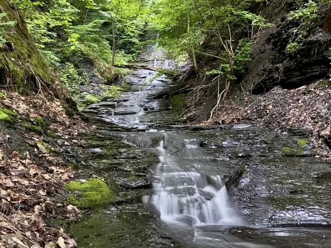
This is not really a hike, but rather a road walk that leads to a very short creek bushwhack. Hikers will park at the large roadside turnout at the coordinates provided and walk northwest along Long Hill Road for a few-hundred feet to reach the nearest creek that passes under the road. Here, hikers will bushwhack through the brush, leading downhill from the road, to reach the creek. Once on the creek, this becomes a very sketchy walk as you slowly make your way up the slippery slate bedrock to reach a view of the 100-foot tall Long Hill Falls.

Parking
Hikers will find a large parking turnout at the coordinates provided.

Pets
Dogs are allowed if leashed and should be cleaned up after.

Warning
Slick bedrock: Walking the bedrock here can be very dangerous as most of it is very slippery. It's very easy to lose your footing, slip, and hit your head on the bedrock so tread lightly and do not push yourself up the creek too far to avoid getting seriously injured. Hikers can view most of the large waterfall from the bottom of the bedrock, despite there being better views upstream.
Explore 33 trails near Moravia, NY
  1. Parking

    42.716047, -76.440612
  2. Main Trailhead

    42.716061, -76.440684
  3. Long Hill Falls (approx. 100-feet tall)

    42.716241, -76.441353
    Long Hill Falls (approx. 100-feet tall)
No community routes found. To add your own hike as a Community Route for this Trail guide, leave a Trip Report with an attached GPX file.

Hazards

Ticks - Lyme Disease More Info (CDC)
Snakes
Poison Ivy/Oak
Rockfalls / Ledges / or Scrambles

Seasons

All

Weather Forecast

In Moravia, NY

Explore Hiking Trails

You May Also Like

Colorado's Million Dollar Highway - Plan a day's drive adventure along the iconic Million Dollar Highway in Colorado. Explore the best short trails, roadside stops, waterfalls, vistas, ghost towns, and hot springs within a ~6 hour road trip.
Explore

Colorado's Million Dollar Highway

Plan a day's drive adventure along the iconic Million Dollar Highway in Colorado. Explore the best short trails, roadside stops, waterfalls, vistas, ghost towns, and hot springs within a ~6 hour road trip.

Read
Glacier's Going-to-the-Sun Road - Discover the breathtaking beauty of Glacier National Park along the iconic Going-to-the-Sun Road. From stunning roadside stops to picturesque waterfalls and vistas, this engineering marvel offers endless opportunities for exploration.
Explore

Glacier's Going-to-the-Sun Road

Discover the breathtaking beauty of Glacier National Park along the iconic Going-to-the-Sun Road. From stunning roadside stops to picturesque waterfalls and vistas, this engineering marvel offers endless opportunities for exploration.

Read
New York's Best Waterfalls - Whether you're planning a day hike, roadside stop, or a leisurely short walk, this guide provides hikers, travelers, and locals alike with 63 different locations to over 100 scenic waterfalls to help plan your next adventure!
Explore

New York's Best Waterfalls

Whether you're planning a day hike, roadside stop, or a leisurely short walk, this guide provides hikers, travelers, and locals alike with 63 different locations to over 100 scenic waterfalls to help plan your next adventure!

Read

Before you boogie...

Find our trail guides useful? Consider becoming a Supporter to unlock perks!

MyHikes is an indie platform that makes exploring public trails easier for everyone. The platform has no investors, no ads, and is owned and operated by one person, Dave Miller. Dave has personally mapped and written over 1,800 trail guides on MyHikes for the public to explore. MyHikes has helped millions outdoor enthusiasts plan their next adventure.

But it takes a lot of time ๐Ÿ•ฆ, money ๐Ÿ’ฐ, work, and espresso shots โ˜• to run MyHikes, including hiking , mapping , writing , and publishing new trails with high-quality (accurate) information... along with software engineering (coding) the platform like building new features, website and mobile app development (iOS and Android), site maintainance . and much much more.

Supporters unlock website and mobile app perks with an annual one-time payment of $25 (you renew) ๐Ÿ˜Ž๐Ÿ‘. Or you can simply make a Donation of your choice. Otherwise, you can support us by telling your friends about MyHikes - both quick and free ๐ŸŽ‰

Admin user profile picture

Dave Miller
MyHikes Founder