Loading...

🎉 Enjoy a Free 7-Day Supporter Trial and Unlock Exclusive Perks — No Credit Card Required. Learn more.

Little Stony Falls Hike

Directions
Map
Pictures
Send to App
Distance:
1.3 Miles / 2.1 km
Type:
Out-and-Back
Difficulty:
Easy
Time to Hike:
~39 minutes
Features:
Surface Type:
Dirt
Park:
Jefferson National Forest
Town:
Dungannon, Virginia
Directions:
36.869404, -82.463614
Added:
February 28, 2025
Updated:
April 05, 2025
Copy Trail Link Hiking this trail? Send a friend or family member a link to this trail guide for your own safety. Hike at your own risk (disclaimer)
Loading...
Loading...
167'

Total Change
183'

Ascent
183'

Descent

Download the Trail Route for Offline Use

Supporters get exclusive access to download trail routes to the MyHikes app for offline use. Stay prepared on your adventure, even without an internet connection! Become a Supporter today to unlock this feature and hike with confidence.

Send to App

Little Stony Falls Hike

This very short hike still manages views of three different waterfalls along Little Stony Creek. The trail is known as the Little Stony National Recreation Trail, however this hike is short because much of the Little Stony Trail’s original length washed out in 2018, and the Forest Service closed access until it can repair the trail – something that has seen little progress over the past several years. If interested in a guide to the rest of this trail and other nearby trails, we recommend purchasing a copy of High Lonesome Trails: Hiking Virginia’s High Knob Region, published in 2021 by Wally Smith, a Biology professor at the nearby University of Virginia’s College at Wise.

Despite the shortened trail, the first part of this hike remains very popular in the Summer, as locals use the stream below the first waterfall as a swimming hole. We went in October so we saw no swimmers, but the changing leaves made for beautiful views of the waterfalls. This trail still has much to offer hikers despite its currently short length, thanks to views of three separate waterfalls. This hike is well worth the trouble it takes to find the trail’s remote trailhead.

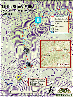
  • Mile 0.0 – The trailhead for this hike is a parking area that also serves as the eastern end of the yellow blazed Chief Benge Trail. The yellow blazed trail starts at the far end of the parking lot, next to a trail kiosk. Begin the hike by descending towards Little Stony Creek.

  • Mile 0.2 – Cross a wooden pedestrian bridge that crosses Little Stony Creek and looks down on the first waterfall. You cannot see the falls from here, but you can hear it, and may see folks swimming in the pool below the falls.

  • Mile 1.6 – The trail comes to some stonework on the downslope side, and there are stone steps down to the creek. Take these steps a short distance for the best views of the first waterfall. This waterfall is the prettiest of the three, and one of the prettiest waterfalls in all of Virginia. This waterfall alone would be worth the trip, but there is more to see, so head back up the stone steps and turn left onto the original trail to continue.

  • Mile 1.7 – The trail passes close to some rocks that jut out over the trail. Shortly after, cross the second bridge over Little Stony Creek. There are nice views both upstream and downstream. Shortly after the bridge, an unblazed side trail to the right descends to Little Stony Creek providing views of the second waterfall. Like the first waterfall, this one is located below the trail bridge. Continue back to the main trail and take a right.

  • Mile 1.8 – The trail reaches a point where the majority of the trail has washed out. The final viewing platform is just after this washed out section of the trail.

  • Mile 1.9 – Reach the viewing platform, with views of the third waterfall. From this point, retrace your steps back to your vehicle.

  • Mile 4.3 – Reach the Little Stony Creek Falls Parking Lot, and return to your vehicle.

By HikingUpward Contributor: Jeff Monroe
Explore 3 trails near Dungannon, VA
  1. Parking

    36.869404, -82.463614
  2. Main Trailhead

    36.869404, -82.463614
No community routes found. To add your own hike as a Community Route for this Trail guide, leave a Trip Report with an attached GPX file.

Hazards

Ticks - Lyme Disease More Info (CDC)
Snakes
Poison Ivy/Oak

Seasons

All

Trip Reports

Trail Guide By:
HikingUpward user profile picture
1.3 miles / 2.1 km

Weather Forecast

In Dungannon, VA

Explore Hiking Trails

You May Also Like

New York's Best Waterfalls - Whether you're planning a day hike, roadside stop, or a leisurely short walk, this guide provides hikers, travelers, and locals alike with 63 different locations to over 100 scenic waterfalls to help plan your next adventure!
Explore

New York's Best Waterfalls

Whether you're planning a day hike, roadside stop, or a leisurely short walk, this guide provides hikers, travelers, and locals alike with 63 different locations to over 100 scenic waterfalls to help plan your next adventure!

Read
25 Best Day Hikes in North Carolina - Discover the top 25 best day hikes in North Carolina, from breathtaking waterfalls to mountain peaks. Explore hidden gems, scenic views, and trails suitable for all skill levels, perfect for your next outdoor adventure.
Explore

25 Best Day Hikes in North Carolina

Discover the top 25 best day hikes in North Carolina, from breathtaking waterfalls to mountain peaks. Explore hidden gems, scenic views, and trails suitable for all skill levels, perfect for your next outdoor adventure.

Read

Before you boogie...

Find our trail guides useful? Consider becoming a Supporter to unlock perks!

MyHikes is an indie platform that makes exploring public trails easier for everyone. The platform has no investors, no ads, and is owned and operated by one person, Dave Miller. Dave has personally mapped and written over 1,800 trail guides on MyHikes for the public to explore. MyHikes has helped millions outdoor enthusiasts plan their next adventure.

But it takes a lot of time 🕦, money 💰, work, and espresso shots ☕ to run MyHikes, including hiking , mapping , writing , and publishing new trails with high-quality (accurate) information... along with software engineering (coding) the platform like building new features, website and mobile app development (iOS and Android), site maintainance . and much much more.

Supporters unlock website and mobile app perks with an annual one-time payment of $25 (you renew) 😎👍. Or you can simply make a Donation of your choice. Otherwise, you can support us by telling your friends about MyHikes - both quick and free 🎉

Admin user profile picture

Dave Miller
MyHikes Founder