Loading...

🍂 Prep for Fall! Unlock exclusive features to plan your perfect late-summer and autumn hikes — become a Supporter today. Learn more.

Little Sluice Hike

Directions
Map
Pictures
Send to App
Distance:
12.7 Miles / 20.4 km
Type:
Loop
Difficulty:
Strenuous
Time to Hike:
6 hours, ~21 minutes
Features:
Surface Type:
Dirt
Park:
George Washington National Forest
Town:
Alonzaville, Virginia
Directions:
38.932457, -78.617821
Added:
February 01, 2025
Updated:
April 04, 2025
Guide by:
Copy Trail Link Hiking this trail? Send a friend or family member a link to this trail guide for your own safety. Hike at your own risk (disclaimer)
Loading...
Loading...
1,549'

Total Change
2,395'

Ascent
2,381'

Descent

Download the Trail Route for Offline Use

Supporters get exclusive access to download trail routes to the MyHikes app for offline use. Stay prepared on your adventure, even without an internet connection! Become a Supporter today to unlock this feature and hike with confidence.

Send to App

Key Takeaways

  • The Little Sluice hike near Alonzaville, VA is a challenging 12.7-mile trail best experienced as an overnight trip due to its length.
  • The hike involves following multiple blazed trails (orange, purple, blue, green, pink, yellow, white) and FR roads, requiring careful attention to trail markers.
  • A recommended highlight is the vista along the white-blazed White Rocks Trail, with an optional campsite nearby.

Little Sluice Hike

A long hike to take in just a single day, the Little Sluice hike is best done as an overnight hike. There is a great campsite on the White Rocks trail, 50 yards from the lookout.

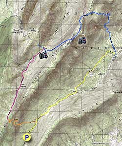
To start, hike up FR88 for 0.5 miles past the gate where you parked and turn left uphill on the orange blazed Bread Road Trail. Follow the trail as it gets steeper for 1.3 miles before coming to the ridge line and junction of the Little Sluice Mountain Trail.

Turn right on the purple blazed Little Sluice Mountain Trail as it descends and rises along the Little Sluice Mountain ridge for the next 2.5 miles. Be alert to remain on the purple blazed trail, as there are several old woods roads that intersect it.

You will arrive at a four way intersection and the purple blazed trail you have been following turns left becoming the blue blazed Tuscarora Trail. You need to make a right turn onto the Tuscarora/Three Ponds Trail which is both green and blue blazed, the greens blazes were used for a deer study.

Ascend for 1.4 miles before beginning your descent where the white blazed White Rocks Trail leads to the best vista of the hike. Turn right and follow the white blazed White Rocks Trail to the vista in 0.3 miles.

After returning to the Tuscarora/Three Ponds Trail, continue for 0.5 miles where you meet the pink blazed Old Mail Trail. Turn right at the trail junction staying on the blue blazed trail . The trail becomes less rocky as you follow it for another 0.3 miles before you need to turn right as the blue blazed trail now turns downhill.

This section of the trail winds through a pine grove before coming to the next trail junction in 1.3 miles. Turn right and cross a small run following the blue blazed trail for another 0.7 miles to the junction of FDR 1863.

Turn right and ascend on yellow blazed FDR 1863 for 1.5 miles before the road ends at a small clearing. At the left of the clearing, yellow blazed Cedar Creek Trail continues downward for another 0.5 miles before meeting the low water route.

Turn right continuing to follow yellow blazed Cedar Creek Trail and pass a small wildlife pond on your left in 0.8 miles. In another 0.5 miles you will emerge onto FR88. Continue down FR88 past Bread Road Trail for another 0.6 miles back to the parking area.

Explore 82 trails near Alonzaville, VA
  1. Parking

    38.932457, -78.617821
  2. Main Trailhead

    38.931947, -78.617435
No community routes found. To add your own hike as a Community Route for this Trail guide, leave a Trip Report with an attached GPX file.

Hazards

Ticks - Lyme Disease More Info (CDC)
Snakes
Poison Ivy/Oak

Seasons

All

Photo Albums

+ Add Photo Album

Upload your photos from the trail to help others know what to expect.

Trip Reports (Reviews)

Rated 3.29 out of 5 based on 14 ratings.
By: The Kidd
12.7 miles / 20.4 km
May 18, 2019
Good overnight hiking in this late spring weekend. If I do it again I'm taking the Stoney Creek Trail back and just return hiking from the White Rocks Trail. Added Little Schloss overlook which was completely worth it. A few notes: The Little Sluice Trail is basically unblazed. I saw 2 blazes the entire length. The Cedar Creek trail was halfway underwater, so probably two miles was ankle deep mud. Right past the spring on Little Sluice, there is a split in the forest road that goes up hill. It's not on the map, so just keep straight. There are campsites at all the trail intersections, and a few along the way.
Legacy Review
By: K. Morley
12.7 miles / 20.4 km
July 08, 2017
Took a small group of Scouts on this loop in counterclockwise approach. Beautiful hike thru the forest with great views from White Rocks where we camped for the night. As other reviewers noted much of this hike on fire roads, which allows for some 2 by 2 hiking and better conversation. Only passed 1 person on first day coming off Tuscaroa trail and headed in different direction and a horseback rider the next morning as we got close the parking area. We did come across a very healthy rattle snake on the yellow fire road, but he offered plenty of warning. The moonrise and sunrise from White Rocks was just awesome. We also had a turkey strut through our site Sunday morning. All in all a good training campout to practice water management for the dry sites we will experience at Philmont.
Legacy Review
By: Colin
12.7 miles / 20.4 km
November 05, 2016
This was a pretty good hike. We did it as an overnight. Finding the trail head was a little iffy, but once there no complaints. You are in fact on logging roads for much of the hike, but they are fairly rough as far as any kind of a road goes so that wasn't an issue for us. Decently tough incline off the bat. View at the top is great- make sure to keep going over the rocks, the view gets better. There are actually campsites all over the trail, so don't feel limited by just the one they list here. We went all the way to the clearing towards the end of the trek (about 2.5 miles left on the hike) and camped there. We also doubled back a few times to add up mileage. Only warning- there is a four way intersection prior to the one they describe. Don't get confused, keep following the blue to the left and over the run (not the right!). Not a lot of water, but definitely a very peaceful hike that is full of solitude. Only saw a couple other hikers and maybe 2-3 hunters returning from their morning hunt.
Legacy Review

Weather Forecast

In Alonzaville, VA

Explore Hiking Trails

You May Also Like

New York's Best Waterfalls - Whether you're planning a day hike, roadside stop, or a leisurely short walk, this guide provides hikers, travelers, and locals alike with 63 different locations to over 100 scenic waterfalls to help plan your next adventure!
Explore

New York's Best Waterfalls

Whether you're planning a day hike, roadside stop, or a leisurely short walk, this guide provides hikers, travelers, and locals alike with 63 different locations to over 100 scenic waterfalls to help plan your next adventure!

Read
25 Best Day Hikes in North Carolina - Discover the top 25 best day hikes in North Carolina, from breathtaking waterfalls to mountain peaks. Explore hidden gems, scenic views, and trails suitable for all skill levels, perfect for your next outdoor adventure.
Explore

25 Best Day Hikes in North Carolina

Discover the top 25 best day hikes in North Carolina, from breathtaking waterfalls to mountain peaks. Explore hidden gems, scenic views, and trails suitable for all skill levels, perfect for your next outdoor adventure.

Read

Before you boogie...

Find our trail guides useful? Consider becoming a Supporter to unlock perks!

MyHikes is an indie platform that makes exploring public trails easier for everyone. The platform has no investors, no ads, and is owned and operated by one person, Dave Miller. Dave has personally mapped and written over 1,800 trail guides on MyHikes for the public to explore. MyHikes has helped millions outdoor enthusiasts plan their next adventure.

But it takes a lot of time 🕦, money 💰, work, and espresso shots ☕ to run MyHikes, including hiking , mapping , writing , and publishing new trails with high-quality (accurate) information... along with software engineering (coding) the platform like building new features, website and mobile app development (iOS and Android), site maintainance . and much much more.

Supporters unlock website and mobile app perks with an annual one-time payment of $25 (you renew) 😎👍. Or you can simply make a Donation of your choice. Otherwise, you can support us by telling your friends about MyHikes - both quick and free 🎉

Admin user profile picture

Dave Miller
MyHikes Founder