Little Schrader Grotto Falls at State Game Lands 12 near Canton, Pennsylvania is an easy 1.5-mile out-and-back hike that leads to the small but scenic grotto waterfall and swimming hole known as Little Schrader Grotto Falls.
Swimming Hole
This hike leads to a scenic backcountry swimming hole. If swimming, do so at your own risk and be on the lookout for weather changes to avoid flash floods.
Hike Description
This hike begins at the main entrance gate to State Game Lands 36 adjacent to Schrader Creek, just west of Marent Road. During most seasons, the trailhead gate is locked; however, during hunting season, the trailhead gate is open and hikers have more freedom to explore; however, this guide assumes you'll hike-in any time of the year where the gate might be closed.
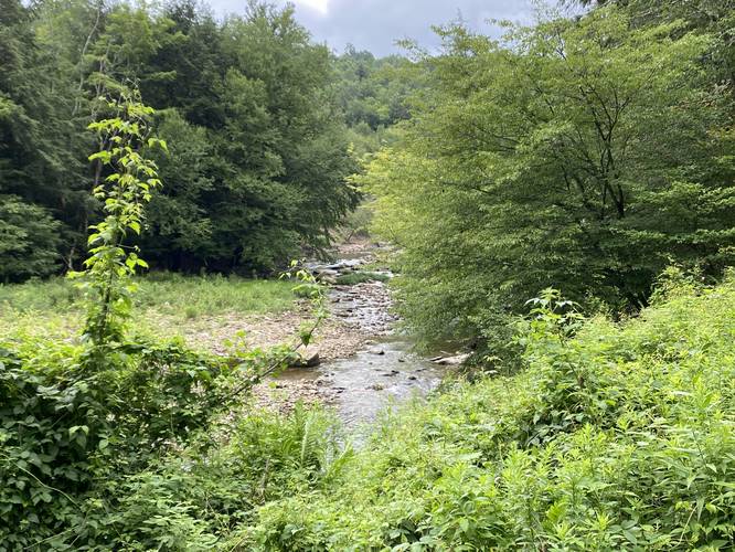
The hike follows the main service road / entrance road and includes some nice views of Schrader Creek on the walk in. The road itself is made-up of crushed stone and is very flat, making the road portion of the hike an easy walk.
Right-Hand Turn - Mile 0.45
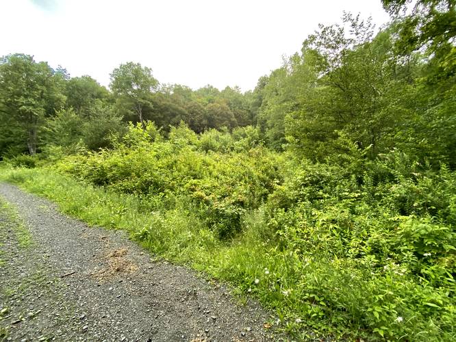
Around mile 0.45, just after the hiker crosses the bridge that spans Little Schrader Creek, you'll take a right-hand turn heading north. During the Summer, this trail may look overgrown, however, the tall grass lasts for ~100-feet before the rest of the trail reveals itself as a wide forested trail that runs adjacent to Little Schrader Creek. Hikers may notice the built-up rock wall that was once used to haul resources out of the forest here - either coal or timber - for resale. Note that this appears to be an old railroad grade path, hence the pictures are labeled as such; however, that's an assumption based on historical industries that once thrived here. Once on the Little Schrader Creek trail, the hike north will quickly lead to the waterfall and grotto.
Reaching the Grotto, Waterfalls, and Swimming Hole - Mile 0.75
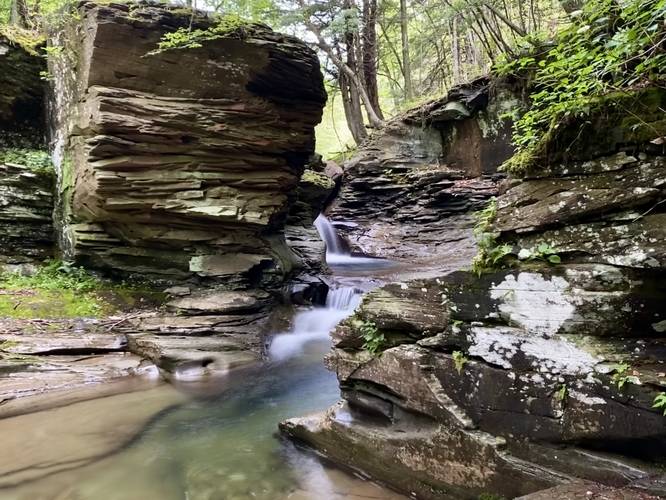
Hikers will spot Little Schrader Grotto with its waterfalls and swimming hole from downstream. Note that there's a sketchy, but short, hillside scramble to reach the base of the waterfall. During low water, hikers can cross the creek to reach a beautiful view into Little Schrader Grotto, which includes the Upper Falls portion of the waterfall. Both upper and lower falls within Little Schrader Grotto provide swimming holes; however, it's unclear how deep upper falls' swimming hole is. The swimming hole at the lower falls portion of the grotto is about 5-feet deep or so, making for a great spot for hikers to cool-off during the Summer.
Hiking Out
The hike out is relatively easy, minus the short but steep scramble to get out from the grotto area. All things considered, this is an easy hike.
Parking
Hikers will find parking at the coordinates provided. The lot is large enough to fit a dozen vehicles or so.
Pets
Dogs are allowed only if leashed and should be cleaned up after.
Warnings
Hunting: Hunting is permitted during specified open seasons. Wearing blaze orange is smart to avoid being shot.
Swimming Hole
This hike leads to a scenic backcountry swimming hole. If swimming, do so at your own risk and be on the lookout for weather changes to avoid flash floods.
Hike Description
This hike begins at the main entrance gate to State Game Lands 36 adjacent to Schrader Creek, just west of Marent Road. During most seasons, the trailhead gate is locked; however, during hunting season, the trailhead gate is open and hikers have more freedom to explore; however, this guide assumes you'll hike-in any time of the year where the gate might be closed.
The hike follows the main service road / entrance road and includes some nice views of Schrader Creek on the walk in. The road itself is made-up of crushed stone and is very flat, making the road portion of the hike an easy walk.
Right-Hand Turn - Mile 0.45
Around mile 0.45, just after the hiker crosses the bridge that spans Little Schrader Creek, you'll take a right-hand turn heading north. During the Summer, this trail may look overgrown, however, the tall grass lasts for ~100-feet before the rest of the trail reveals itself as a wide forested trail that runs adjacent to Little Schrader Creek. Hikers may notice the built-up rock wall that was once used to haul resources out of the forest here - either coal or timber - for resale. Note that this appears to be an old railroad grade path, hence the pictures are labeled as such; however, that's an assumption based on historical industries that once thrived here. Once on the Little Schrader Creek trail, the hike north will quickly lead to the waterfall and grotto.
Reaching the Grotto, Waterfalls, and Swimming Hole - Mile 0.75
Hikers will spot Little Schrader Grotto with its waterfalls and swimming hole from downstream. Note that there's a sketchy, but short, hillside scramble to reach the base of the waterfall. During low water, hikers can cross the creek to reach a beautiful view into Little Schrader Grotto, which includes the Upper Falls portion of the waterfall. Both upper and lower falls within Little Schrader Grotto provide swimming holes; however, it's unclear how deep upper falls' swimming hole is. The swimming hole at the lower falls portion of the grotto is about 5-feet deep or so, making for a great spot for hikers to cool-off during the Summer.
Hiking Out
The hike out is relatively easy, minus the short but steep scramble to get out from the grotto area. All things considered, this is an easy hike.
Parking
Hikers will find parking at the coordinates provided. The lot is large enough to fit a dozen vehicles or so.
Pets
Dogs are allowed only if leashed and should be cleaned up after.
Warnings
Hunting: Hunting is permitted during specified open seasons. Wearing blaze orange is smart to avoid being shot.