Loading...

WINTER SALE! 50% OFF Supporter Accounts — now through January 31st. Learn More.

Little Schloss Hike

Little Schloss is just one of the many beautiful circuit hikes in the Great North Mountain area. Only 1.7 miles east of the more popular Big Schloss, the Little Schloss overlook is nearly all but forgotten. The panoramic vista from Little Schloss is spectacular, however the rock scramble to to the summit does require some skill. But this hike isn't just about the summit, 0.3 past the overlook there are several beautiful vistas on the trail, as well as a clearing with mature spruce. Little Stoney Creek is also a favorite with backpackers, and has many camping sites along its banks.
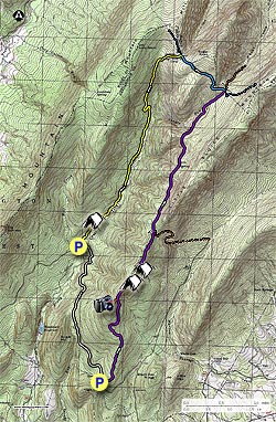
  • Mile 0.0 - From the parking area cross FDR92 and start up the purple blazed Little Sluice Mountain Trail. The trail will increase in steepness, then in 1.0 miles turn down its eastern side before heading steeply back towards the ridge. At this point, there are also several good views of Stultz Gap to the southeast. The trail will make switchbacks near the ridgeline and become increasingly steeper.
  • Mile 1.8 - After the last switchback the trail will split. Stay left to go to the overlook. The 70ft rock scramble to the Little Schloss overlook is a very steep, so if you decide to tackle the climb use caution as some of the rocks are loose.
  • Mile 1.9 - From the Little Schloss overlook Big Schloss is visible to the west, as well as the the ridge of Little Sluice Mountain to the north, and Woodstock to the east. Return back to the trail split from the overlook and head north on the purple blazed Little Sluice Mountain Trail passing several vistas. 0.3 miles along the ridge the trail will pass the first good campsite.
  • Mile 2.5 - Enter a high mountain meadow with a campsite and stand of mature spruce. On the east side of the clearing in the woodline is camping area with one of the largest backcountry fire rings we've seen.

    If you are doing the shorter out/back hike this is the turn around point.

    To continue on the 13.2 mile loop hike, the purple blazed Little Sluice Trail follows a wider seasonal forestry road (FR), then gradually descends before reaching the intersection of the orange blazed Bread Trail/FR in another 0.9 miles.

  • Mile 3.4 - Stay left along the purple blazed trail/FR for 2.5 miles, where the purple blazed trail ends at the intersection of the blue blazed Tuscarora Trail, and orange blazed Racer Camp Hollow Trail that continues straight.
  • Mile 5.9 - Turn left uphill on the blue blazed Tuscarora Trail as it passes over Sugar Knob, then descends and arrives at the intersection of the yellow blazed Little Stoney Creek Trail in another 1.0 mile.
  • Mile 6.9 - Turn left down the yellow blazed Little Stoney Creek Trail, and in 100 yards pass the PATC Sugar Knob Cabin, then 70 yards further down the trail is a seasonal spring. The yellow blazed Little Stoney Creek Trail will continue down the valley for 2.5 miles before reaching the next campsite along the banks of the creek. Pass several more campsites in the remaining 1.3 miles to FDR92, and the Little Stoney Creek parking area.
  • Mile 10.7 - Turn left and walk the remaining 2.5 miles along FDR92 back to the Little Sluice Trail parking area.
  • Mile 12.3 - Arrive back at the parking area on FDR92
Explore 87 trails near Maurertown, VA

Know Before You Go

  • The Little Schloss hike in Maurertown, VA offers a 12.3-mile loop with a challenging rock scramble to a scenic overlook, plus additional vistas, campsites, and a high mountain meadow with mature spruce.
  • The full loop involves various trail blazes (purple, orange, blue, yellow) and sections along a forestry road and FDR92, with opportunities for shorter out-and-back hikes.
  • Little Stoney Creek is a key feature, offering multiple campsites and a water source (seasonal spring near the PATC Sugar Knob Cabin), but the final 2.5 miles of the hike are along a road (FDR92).
Interactive topographic map for Little Schloss Hike located in Maurertown, VA. Click the "View Map" button to load GPS coordinates and trail markers.
Get directions
Distance
12.3 mi
Difficulty
Hard
Type
Loop
Est. Time
6.2 hrs
Elev. Gain
2,348'
Rating
3.8
Added
February 01, 2025
Updated
April 04, 2025

Weather Forecast

Tonight
Low 18°F
Partly Cloudy
M.L. King Jr. Day
High 32°F
Sunny
Monday Night
Low 10°F
Mostly Clear
Tuesday
High 22°F
Sunny
Tuesday Night
Low 11°F
Mostly Clear
Wednesday
High 39°F
Sunny
Wednesday Night
Low 27°F
Mostly Cloudy
Thursday
High 39°F
Slight Chance Light Snow
Thursday Night
Low 17°F
Mostly Clear
Friday
High 36°F
Mostly Sunny
Friday Night
Low 20°F
Partly Cloudy then Slight Chance Light Snow
Saturday
High 32°F
Chance Light Snow
Saturday Night
Low 15°F
Chance Light Snow
Sunday
High 23°F
Chance Light Snow
Loading...
Total Change
1,582'
Ascent
2,348'
Descent
2,345'
Loading...

Download the GPX Data for Offline Use

Supporters get exclusive access to download trail routes to the MyHikes app for offline use. Stay prepared on your adventure, even without an internet connection! Become a Supporter today to unlock this feature and hike with confidence.

Download Little Schloss Hike GPX Data to the MyHikes Mobile App

Features

Vista / Lookout Point
Dogs
Mountain Summit
Camping
Water Source

Points of interest

  1. Parking

    38.90833, -78.640846
  2. Main Trailhead

    38.908314, -78.640823

Safety information

For your own safety: plan ahead, let someone know where you'll be, and hike at your own risk.

Hazards

Snakes (Rattlesnakes, Copperheads, others)
Poison Ivy or Poison Oak

Availability

All seasons

Surface type

Dirt

Trip Reports (Reviews)

Rated 3.76 out of 5 based on 50 ratings.

Ready to help fellow hikers? Add a trip report to share your experience and provide valuable insights for other hikers!

By: Swass
12.3 miles / 19.8 km
June 22, 2019
The trail and scramble were awesome. No rattlesnakes this time. The view from the tops is spectacular and there is not too hard path up. There were a couple parts that were overgrown but that's expected on any trail over 5 miles in the area. Overall the trail was well marked and the directions here were spot on. There was some pooling of water, including a couple of puddles that had tadpoles they were so big but most of them were easily traversed. The last bit, the walk on the fire road back to the parking lot is even pleasant for hiking on a road with ample shade.
Legacy Review
By: ms960
12.3 miles / 19.8 km
October 08, 2018
Hiked this and the Mill Mountain trail over the weekend of Oct 6- 8, 2018. Started up Little Sluice trail to Little Schloss (great view), turned left onto the Tuscarora Trail, turned left again onto Mill Mountain Trail, side hiked Big Schloss (all fogged in -- no view at all), then down the Big Schloss cutoff trail back to the car. All told about 15 miles over two nights. Great hike. Trail was not crowded at all (saw maybe a half-dozen people all weekend). Great weather, nice trails, although parts of the Little Sluice trail were muddy and wet (due to recent rain? Hasn't been like that on past trips). Lovely area to hike in. The spring on Little Sluice trail was running well (38.9573, -78.6200). Sandstone Spring (38.96901, -7864256) was running very strong with plenty of water. (Posting this under the Mill Mountain hike also).
Legacy Review
By: Claire
12.3 miles / 19.8 km
March 10, 2018
Overall, a really great one night backpacking trip close to DC. I knocked off one star because I could not for the life of me find the trail split to go to the Little Schloss overlook. It could be possible that the recent wind storm obscured the entrance with downed trees, but I didn't see any markings of any kind. I'll definitely keep a sharper eye out next time I do this loop. Even though I missed the official overlook, there were still plenty of nice views from the trail after passing Little Schloss. Also important to note that FR88 was closed about a mile from the intersection with FR92, so that added an extra 1.5 miles each way to my hike to get to and from the Little Sluice trail head. The hiking was very easy, but it was irritating to finish the loop on 4 miles of fairly featureless forest road. Won't knock off a star for that though, since it's not really the trail's fault! There is a great campsite just past the intersection with Little Stoney Creek Trail on the left, which is where I spent the night. The spring is marked with a wooden sign nailed to a tree a ways down the trail from the PATC cabin. It was running freely in mid-March, which was lucky as there weren't any water sources before that. Between my parking spot on FR88 and my campsite took me about 4.5 hours including breaks. The second day of hiking was much easier, as it was mostly downhill and about half on a forest road. Took me about 3.5 hours (including the 1.5 miles between the Little Sluice parking area and where I actually parked). There are some really beautiful campsites on Little Stoney Creek Trail too.
Legacy Review
No community routes found. To add your own hike as a Community Route for this Trail guide, leave a Trip Report with an attached GPX file.

Popular categories

Scenic mountain view representing vista trails
Vista trails
Scenic gorge of cascades representing waterfall trails
Waterfall hikes
Rugged mountain terrain representing summit trails
Summit trails
Scenic mountain view representing dog-friendly trails
Dog-friendly
Scenic campsite with a view representing camping trails
Camping trails
Appalachian Trail logo representing A.T. hikes
A.T. hikes

You May Also Like

25 Best Day Hikes in North Carolina - Discover the top 25 best day hikes in North Carolina, from breathtaking waterfalls to mountain peaks. Explore hidden gems, scenic views, and trails suitable for all skill levels, perfect for your next outdoor adventure.
Explore

25 Best Day Hikes in North Carolina

Discover the top 25 best day hikes in North Carolina, from breathtaking waterfalls to mountain peaks. Explore hidden gems, scenic views, and trails suitable for all skill levels, perfect for your next outdoor adventure.

Read
🍪 We use cookies to learn about site usage and to serve map tiles. You may block cookies manually in the browser. By continuing you agree. Learn more