Loading...

❄️ WINTER SALE! 50% OFF on Supporter Accounts — now through January 31st. Unlock a full year of exclusive website & app perks. Learn More.

Little Bennett Regional Park Hike

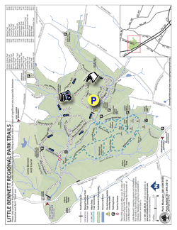
Little Bennett Regional Park has a labyrinth of over 21 miles of trails in its 3,700 acres. There are also 16 historic sites in the park that can be found in the full brochure, with the circuit we have mapped here taking you past the Norwood Tobacco Barn, Wims Meadow, and Wilson's Mill. There is also an extensive wetland area on the Western Piedmont Trail, which is home to the Eastern Bluebird and Timberdoodle.

If you're looking for a great boy scout camping area the hike-in campsite on the Purdum Trail is one of the best we've seen. Open from March through November, the site can be reserved for a nominal fee at 301-528-3430.

The hike outline below is a 6.2 mile circuit that uses many of the multi-use trails on the northern side of Little Bennett Creek. Horses and mountain bikers are likely to be encountered on this circuit. If you're looking to add a little more distance, you can make the hike 10+ miles by adding Bennett Ridge, Whitetail, and the Stoney Brook trails on the south side of Little Bennett Creek.

  • Mile 0.0 – From the Kingsley parking area the Hard Cider trailhead is located to the right of the kiosk. Follow the Hard Cider Trail as it winds over several small ridges and crosses a footbridge then arrives at the intersection of the Purdum Trail.
  • Mile 1.0 - Turn left uphill on the Purdum Trail and in a short distance the trail will split. Take the left fork and continue to where the trail joins a gravel service road.
  • Mile 1.1 - Stay left on the service road for 0.3 miles to the hike-in campground. The campground has several large fire rings, picnic tables, as well as wooden seating. After passing the campground the Purdum Trail passes the intersection of the Loggers Trail in another 0.1 miles. Continue straight on the Purdum Trail to the Browning Run Trail intersection.
  • Mile 1.6 - Turn left on the Browning Run Trail as is gently climbs a rise. At this point the trail is wide and resembles an old horse and carriage lane. At the top of the rise there is a field to the right, and the trail turns left downward. Follow the trail downhill and cross a creek and wooden walkway. After crossing the walkway the trail enters a field. Stay right and continue on the Browning Run Trail to the top of the rise to the intersection of the Pine Knob Trail.
  • Mile 2.4 - At the Pine Knob Trail stay right downhill towards the Browning Run Parking area. At the parking area the trail passes the Lewisdale Trail. Stay on the Browning Run Trail and carefully cross Clarksburg Rd. The trail will cross another footbridge, then climb to the 4-way intersection of the Tobacco Barn Trail.
  • Mile 3.3 - Turn right downhill on the Tobacco Barn Trail passing another field on the left. The Tobacco Barn Trail will then cross Browning Run. There is no footbridge at this crossing, and after heavier rains this can be a challenge to ford. The Tobacco Barn Trail will climb through another field and pass an unofficial trail on the left, then arrives at the ridge an ruins of the Norwood Tobacco Barn. Jeremiah Norwood owned a 68 acre farm on this site in the late 19th century.
  • Mile 3.8 - The Tobacco Barn Trail now turns right uphill. Continue straight on the Timber Ridge Trail. Shortly pass another unofficial trail on the right where the Timber Ridge Trail turns left. Cross a wooden walkway, after which the trail steeply climbs a rise. Continue to where the Timber Ridge Trail ends at the intersection of the Pine Grove Trail.
  • Mile 4.4 - At the junction of the Pine Grove Trail turn left. Pass through a stand of pine, then descend to the intersection of the gravel Western Piedmont Trail.
  • Mile 5.0 - Stay left on the gravel service road/Western Piedmont Trail and immediately pass the small Earls' Picnic Ground. Follow the gravel road until it crosses Browning Run over a small bridge. Turn right taking a side loop past Wims Meadow. James 'Jim' Wims was a local farmer who purchased the property in 1919. He took the field out of production, and converted it into a recreation area for children to play baseball. Continue on the side trail until it rejoins the Western Piedmont Trail.
  • Mile 5.4 - Turn right on the gravel Western Piedmont Trail for the remainder of the hike back to Clarksburg Road and parking area. On the way to the parking area pass 2 trail intersections, as well as a wetland area that is home to both the Eastern Bluebird and Timberdoodle.
  • Mile 6.7 - Arrive back at the Kingsley parking area after crossing Clarksburg Road.
Explore 28 trails near Clarksburg, MD

Know Before You Go

  • Little Bennett Regional Park in Clarksburg, MD, offers a 6.7-mile hiking circuit on the northern side of Little Bennett Creek with historical sites and diverse terrain suitable for horses and mountain bikers.
  • The Purdum Trail features a hike-in campsite (open March-November, reservation required) and can be accessed via the Hard Cider Trail from the Kingsley parking area.
  • The hike includes points of interest like the Norwood Tobacco Barn ruins, Wims Meadow, diverse wildlife viewing opportunities in the Western Piedmont Trail wetland area and potential creek crossings at Browning Run.
Interactive topographic map for Little Bennett Regional Park Hike located in Clarksburg, MD. Click the "View Map" button to load GPS coordinates and trail markers.
Get directions
Distance
6.7 mi
Difficulty
Moderate
Type
Loop
Est. Time
3.4 hrs
Elev. Gain
624'
Rating
4.0
Added
March 22, 2025
Updated
April 06, 2025

Weather Forecast

Tonight
Low 41°F
Mostly Cloudy
Wednesday
High 49°F
Chance Light Rain
Wednesday Night
Low 22°F
Rain And Snow Likely
Thursday
High 28°F
Slight Chance Light Snow then Mostly Sunny
Thursday Night
Low 16°F
Mostly Clear
Friday
High 33°F
Mostly Sunny
Friday Night
Low 27°F
Partly Cloudy
Saturday
High 42°F
Mostly Sunny then Slight Chance Rain And Snow
Saturday Night
Low 21°F
Slight Chance Rain And Snow then Mostly Cloudy
Sunday
High 28°F
Slight Chance Light Snow
Sunday Night
Low 16°F
Partly Cloudy
M.L. King Jr. Day
High 31°F
Mostly Sunny
Monday Night
Low 16°F
Partly Cloudy
Tuesday
High 26°F
Mostly Sunny
Loading...
Total Change
249'
Ascent
624'
Descent
624'
Loading...

Download the GPX Data for Offline Use

Supporters get exclusive access to download trail routes to the MyHikes app for offline use. Stay prepared on your adventure, even without an internet connection! Become a Supporter today to unlock this feature and hike with confidence.

Download Little Bennett Regional Park Hike GPX Data to the MyHikes Mobile App

Features

Dogs
Camping
Water Source

Points of interest

  1. Parking

    39.265872, -77.280246
  2. Main Trailhead

    39.265986, -77.2803

Safety information

For your own safety: plan ahead, let someone know where you'll be, and hike at your own risk.

Hazards

Snakes (Rattlesnakes, Copperheads, others)
Poison Ivy or Poison Oak

Availability

All seasons

Surface type

Dirt

Trip Reports (Reviews)

Rated 4.0 out of 5 based on 4 ratings.

Ready to help fellow hikers? Add a trip report to share your experience and provide valuable insights for other hikers!

7.8 miles / 12.6 km
September 05, 2025
BEWARE: This route is very outdated- there are several sections that are completely closed / rerouted now and I had to double back and take a longer route to complete the loop- ended up going almost 8 miles. This trail is also a bit highly rated for what it is. I can see why locals love the park so much; the trails are very well maintained and there's a lot of them, and while there's enough terrain to be interesting there's very little that was particularly steep.. I would be there all the time if I lived close by, but other than a couple of modestly interesting historical spots and some nice meadows, it's short on views / destinations. I hiked on a weekday and I saw 5 mountain bikes for every hiker; judging by tire tracks I suspect on weekends you'd be dodging a lot of bikes.
Hiking
By: Morris
6.7 miles / 10.8 km
October 07, 2017
I hike Little Bennett quite frequently, and very much enjoy the experience over walking around suburban sidewalks that are close by. On this day, I even helped a turtle off of the access road to the hike-in camp on Purdum trail, so there is wildlife in the park! I believe that a new trail manager was assigned to the park in the last year or so, and they have been aggressively re-routing a LOT of trails in the park, so use the most recent map you can find. The re-routing has been outstanding, fixing lots of long-term problems with erosion and construction of some trails directly along the fall line. The Tobacco Barn trail, for example, has been re-routed to avoid the wet crossing and the highly eroded climb. It now ends a few hundred feet up Clarksburg Road from the parking area, so there is a short roadwalk back to the nearby parking area where the trails continue. If you live in the area, it is a real nicety to have such a park close by that you can get a good hike in the woods.
Legacy Review
By: Margaret
6.7 miles / 10.8 km
June 28, 2015
I've been to this park twice and hiked just about all of the trails. I started out to do this one the first time but then ended up at the wrong parking area, so I just kinda went with it. Little Bennett has a fire road bisecting it, and there are basically two big loops with interconnecting trails making it possible to do a variety of distances. You can tailor your hike to fit your needs, and maps are posted at most entrances. It's a nice park, and just about any route will take you through forest and some lovely meadows. The park is also home to the endangered Allegheny mound-builder ant. I was too squeamish to venture down the trail that visits a number of their mounds, but you see many on nearby routes. They're sure impressive! This is a nice half-day hike. It visits one of the prettiest meadows in the area, and winds through peaceful woods. You may encounter deer, black snakes, chipmunks, etc. but for me the highlight was seeing the many birds and butterflies in the meadow. It's hilly enough that you feel like you've done something but not so much that you'll be exhausted. There is a stream crossing that the hike description mentions can be difficult after heavy rain - this is not an exaggeration! I ended up taking off my boots and going through the knee-deep channel barefoot. No big deal, but it's a consideration if you are doing this in winter. It'd be relatively easy to pick another route and go around, though.
Legacy Review

Explore other routes for this Trail guide, added by the MyHikes' community via Trip Reports (Reviews). To add your own hike as a Community Route for this Trail guide, leave a Trip Report and attached your GPX file!

Popular categories

Scenic mountain view representing vista trails
Vista trails
Scenic gorge of cascades representing waterfall trails
Waterfall hikes
Rugged mountain terrain representing summit trails
Summit trails
Scenic mountain view representing dog-friendly trails
Dog-friendly
Scenic campsite with a view representing camping trails
Camping trails
Appalachian Trail logo representing A.T. hikes
A.T. hikes

You May Also Like

Colorado's Million Dollar Highway - Plan a day's drive adventure along the iconic Million Dollar Highway in Colorado. Explore the best short trails, roadside stops, waterfalls, vistas, ghost towns, and hot springs within a ~6 hour road trip.
Explore

Colorado's Million Dollar Highway

Plan a day's drive adventure along the iconic Million Dollar Highway in Colorado. Explore the best short trails, roadside stops, waterfalls, vistas, ghost towns, and hot springs within a ~6 hour road trip.

Read
🍪 We use cookies to learn about site usage and to serve map tiles. You may block cookies manually in the browser. By continuing you agree. Learn more