Loading...

🎉 Enjoy a Free 7-Day Supporter Trial and Unlock Exclusive Perks — No Credit Card Required. Learn more.

Little Bald Knob Ridge Hike

Directions
Map
Pictures
Send to App
Distance:
6.4 Miles / 10.3 km
Type:
Out-and-Back
Difficulty:
Hard
Time to Hike:
3 hours, ~12 minutes
Features:
Surface Type:
Dirt
Park:
George Washington National Forest
Town:
West Augusta, Virginia
Directions:
38.368893, -79.273653
Added:
February 01, 2025
Updated:
April 04, 2025
Copy Trail Link Hiking this trail? Send a friend or family member a link to this trail guide for your own safety. Hike at your own risk (disclaimer)
Loading...
Loading...
1,983'

Total Change
2,312'

Ascent
2,314'

Descent

Download the Trail Route for Offline Use

Supporters get exclusive access to download trail routes to the MyHikes app for offline use. Stay prepared on your adventure, even without an internet connection! Become a Supporter today to unlock this feature and hike with confidence.

Send to App

Little Bald Knob Ridge Hike

The hike is located in the beautiful Todd Lake area of the GWNF. Excellent car camping is abundant throughout the area with sites scattered along North River, as well as the North River and Todd Lake contemporary camping areas. Little Bald Knob itself doesn't have any views from the summit, but there are many spectacular vistas along the ridge. 1/4 past the summit are the ridgeline meadows and a great place for lunch and turn around spot.


The Little Bald Knob hike heads north on the Wild Oak Trail where it crosses North River. A great way to spend the weekend is to camp along North River and hike south along the Wild Oak Trail to Hardscrabble Knob one day, then hike up to the Little Bald Knob Ridge from the camping area the next. There are also several other hikes located in this trail system within a 10 minute drive, including Trimble Mountain, North River Gorge, and Sand Spring Mountain.

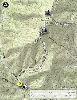
  • Mile 0.0 - From FR95 at Camp Todd head north on the white blazed Wild Oak Trail where the trail will cross North River.

  • Mile 0.2 - Pass the FR95 connector trail. Continue more steeply uphill on the Wild Oak Trail. From this point the Wild Oak Trail climbs through Horse Trough Hollow as it winds steeply uphill.

  • Mile 2.3 - Make a sharp right turn, then arrive at a flat section of the ridge in another 0.25 miles.

  • Mile 2.55 - From the flat on the ridge the Wild Oak Trail will descend through a saddle and pass the best vista of the hike. Look for a short side trail on the right.

    If you don't want to go the the ridge meadows this is a good turn around point, making for a total hike length of 5.4 miles

  • Mile 2.7 - From the vista the trail climbs through a section of Mountain Laurel and passes over the summit of Little Bald Knob. There is no overlook or 'Bald' here, and the trail will begin to descend, and shortly arrive at the intersection of the Bald Mountain Road where the Wild Oak Trail makes a sharp right downhill.

  • Mile 3.25 - From the intersection continue straight on the wider Bald Mountain Road for 0.25 miles and arrive at the high mountain meadows.

  • Mile 3.5 - From the high mountain meadows retrace your route back to North River and Camp Todd.

  • Mile 6.4 Arrive back at the parking area at Camp Todd.

Explore 29 trails near West Augusta, VA
  1. Parking

    38.368893, -79.273653
  2. Main Trailhead

    38.368893, -79.273653
No community routes found. To add your own hike as a Community Route for this Trail guide, leave a Trip Report with an attached GPX file.

Hazards

Ticks - Lyme Disease More Info (CDC)
Snakes

Seasons

All

Blaze Color

White

Trip Reports

Trail Guide By:
HikingUpward user profile picture
6.4 miles / 10.3 km

Weather Forecast

In West Augusta, VA

Explore Hiking Trails

You May Also Like

New York's Best Waterfalls - Whether you're planning a day hike, roadside stop, or a leisurely short walk, this guide provides hikers, travelers, and locals alike with 63 different locations to over 100 scenic waterfalls to help plan your next adventure!
Explore

New York's Best Waterfalls

Whether you're planning a day hike, roadside stop, or a leisurely short walk, this guide provides hikers, travelers, and locals alike with 63 different locations to over 100 scenic waterfalls to help plan your next adventure!

Read
25 Best Day Hikes in North Carolina - Discover the top 25 best day hikes in North Carolina, from breathtaking waterfalls to mountain peaks. Explore hidden gems, scenic views, and trails suitable for all skill levels, perfect for your next outdoor adventure.
Explore

25 Best Day Hikes in North Carolina

Discover the top 25 best day hikes in North Carolina, from breathtaking waterfalls to mountain peaks. Explore hidden gems, scenic views, and trails suitable for all skill levels, perfect for your next outdoor adventure.

Read

Before you boogie...

Find our trail guides useful? Consider becoming a Supporter to unlock perks!

MyHikes is an indie platform that makes exploring public trails easier for everyone. The platform has no investors, no ads, and is owned and operated by one person, Dave Miller. Dave has personally mapped and written over 1,800 trail guides on MyHikes for the public to explore. MyHikes has helped millions outdoor enthusiasts plan their next adventure.

But it takes a lot of time 🕦, money 💰, work, and espresso shots ☕ to run MyHikes, including hiking , mapping , writing , and publishing new trails with high-quality (accurate) information... along with software engineering (coding) the platform like building new features, website and mobile app development (iOS and Android), site maintainance . and much much more.

Supporters unlock website and mobile app perks with an annual one-time payment of $25 (you renew) 😎👍. Or you can simply make a Donation of your choice. Otherwise, you can support us by telling your friends about MyHikes - both quick and free 🎉

Admin user profile picture

Dave Miller
MyHikes Founder