Loading...

๐ŸŒฒ WINTER SALE! 50% OFF on Supporter Accounts โ€” now through December 31st. Unlock a full year of exclusive website & app perks for better hikes. Learn More.

Linear Park Trail

Directions
Map
Pictures
Download Linear Park Trail GPX Data to the MyHikes Mobile App
Distance:
0.7 Miles / 1.1 km
Type:
Out-and-Back
Difficulty:
Easy
Time to Hike:
~21 minutes
Features:
Surface Type:
Paved
Park:
Linear Park
Town:
Grand Haven, Michigan
Get Directions:
43.06947, -86.229992
Added:
February 03, 2020
Updated:
February 03, 2020
Guide by:
Copy Trail Link Hiking this trail? Send a friend or family member a link to this trail guide for your own safety. Hike at your own risk (disclaimer)
Loading...
Loading...
1'

Total Change
17'

Ascent
17'

Descent

Download the GPX Data for Offline Use

Supporters get exclusive access to download trail routes to the MyHikes app for offline use. Stay prepared on your adventure, even without an internet connection! Become a Supporter today to unlock this feature and hike with confidence.

Download Linear Park Trail GPX Data to the MyHikes Mobile App

Key Takeaways

  • The Linear Park Trail in Grand Haven, MI is a short, 0.7-mile paved trail offering views of the Grand River and South Channel.
  • The trail is located in Linear Park on Harbor Island, running from the Third Street Bridge to the power plant, and includes amenities like picnic tables, grills, and fishing platforms.
  • Due to high water levels, parts of the trail may be damaged or collapsed, requiring hikers to exercise extreme caution.

Linear Park Trail

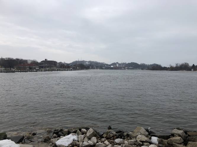
The Linear Park Trail at Linear Park in Grand Haven, Michigan is an easy 0.7-mile out-and-back paved trail that features views of Grand River.

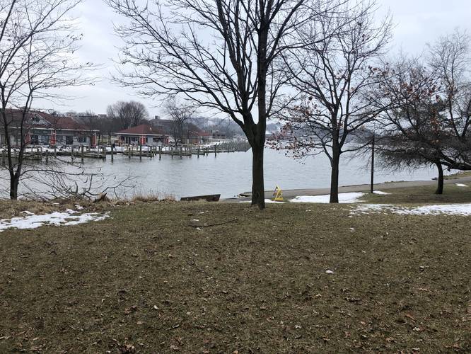
Linear Park is located on Harbor Island directly across the channel from Chinook Pier. The park, and this trail, run from the Third Street Bridge to the power plant, where the South Channel joins the Grand River. Hikers will find plenty of nice views of the South Channel and Grand River along the entire trail.

Amenities
Hikers will find picnic tables with grills, platforms for fishing, and interpretive signs.

Note:ย 
Owing to the current very level of the water table in Michigan, this park has been significantly compromised in certain spots, including total collapse of some of the paved path. Hikers are encouraged to exerciseย extreme caution.

Explore 16 trails near Grand Haven, MI
  1. Parking

    43.06947, -86.229992
  2. Main Trailhead

    43.06947, -86.229992
  3. Lookout point at the end of the trail - View of Grand River

    43.067897, -86.234169
    Lookout point at the end of the trail - View of Grand River
  4. high water is impacting this park quite heavily

    43.068092, -86.233233
    high water is impacting this park quite heavily
  5. Pere Marquette park seen from across the channel

    43.069186, -86.230414
    Pere Marquette park seen from across the channel
  6. high water is impacting this park quite heavily

    43.068858, -86.231347
    high water is impacting this park quite heavily
  7. high water is impacting this park quite heavily

    43.06895, -86.231353
    high water is impacting this park quite heavily
  8. high water is impacting this park quite heavily

    43.067978, -86.233775
    high water is impacting this park quite heavily
  9. Point-of-Interest

    43.068278, -86.233339
    Point-of-Interest
No community routes found. To add your own hike as a Community Route for this Trail guide, leave a Trip Report with an attached GPX file.

Hazards

Ticks - Lyme Disease More Info (CDC)

Seasons

All

Photo Albums

+ Add Photo Album

Upload your photos from the trail to help others know what to expect.

Trip Reports (Reviews)

Ready to help fellow hikers? Add a trip report to share your experience and provide valuable insights for those planning their next hike. Your review makes the trail better for everyone.

Your opinion matters! Be the first to rate this trail.

Weather Forecast

In Grand Haven, MI

Explore Hiking Trails

You May Also Like

Colorado's Million Dollar Highway - Plan a day's drive adventure along the iconic Million Dollar Highway in Colorado. Explore the best short trails, roadside stops, waterfalls, vistas, ghost towns, and hot springs within a ~6 hour road trip.
Explore

Colorado's Million Dollar Highway

Plan a day's drive adventure along the iconic Million Dollar Highway in Colorado. Explore the best short trails, roadside stops, waterfalls, vistas, ghost towns, and hot springs within a ~6 hour road trip.

Read
Glacier's Going-to-the-Sun Road - Discover the breathtaking beauty of Glacier National Park along the iconic Going-to-the-Sun Road. From stunning roadside stops to picturesque waterfalls and vistas, this engineering marvel offers endless opportunities for exploration.
Explore

Glacier's Going-to-the-Sun Road

Discover the breathtaking beauty of Glacier National Park along the iconic Going-to-the-Sun Road. From stunning roadside stops to picturesque waterfalls and vistas, this engineering marvel offers endless opportunities for exploration.

Read

Before you boogie...

Find our trail guides useful? Consider becoming a Supporter to unlock perks!

MyHikes is an indie platform that makes exploring public trails easier for everyone. The platform has no investors, no ads, and is owned and operated by one person, Dave Miller. Dave has personally mapped and written over 1,900 trail guides on MyHikes for the public to explore. MyHikes has helped millions outdoor enthusiasts plan their next adventure.

But it takes a lot of time ๐Ÿ•ฆ, money ๐Ÿ’ฐ, work, and espresso shots โ˜• to run MyHikes, including hiking , mapping , writing , and publishing new trails with high-quality (accurate) information... along with software engineering (coding) the platform like building new features, website and mobile app development (iOS and Android), site maintainance . and much much more.

Supporters unlock website and mobile app perks with an annual one-time payment of $25 (you renew) ๐Ÿ˜Ž๐Ÿ‘. Or you can simply make a Donation of your choice. Otherwise, you can support us by telling your friends about MyHikes - both quick and free ๐ŸŽ‰

Admin avatar

Dave Miller
MyHikes Founder
๐Ÿช We use cookies to learn about site usage, performance, and to serve map tiles. You may block cookies manually in the browser. By continuing to use MyHikes, you agree. Learn more