Lee Pass to Kolob Arch at Zion National Park in New Harmony, Utah is a difficult 14.4-mile out-and-back trail that leads to the stunning Kolob Arch.
Temporarily Closed
Note that as of September 2023, this section of Zion National Park is closed due to necessary road repairs after recent landslides. The road is not slated to be open to the public until sometime in 2024.
Trail: La Verkin Creek Trail, Kolob Arch Trail.
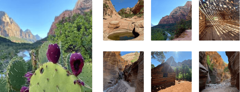
This hike starts off along the La Verkin Creek Trail and follows this trail for almost the entirety of the trek. You will pass along many creeks, most of them you will have to cross by practicing your dance moves on the rocks - so hiking poles can come in handy on this trail. If you carry a water filter, you can filter water in the creeks, but bring plenty of water for this long and difficult hike. The trail twists and turns along throughout the canyon floor giving you plenty of chances to capture the towering rocks above you.
At approximately 6.5-miles into the hike, you'll find the trail junction for the Kolob Arch Trail. Take a left-hand turn here to follow the short Kolob Arch Trail up to the view point for Kolob Arch itself.
Once you reach the Kolob Arch you will need to take that recharge break before you head back to the trailhead.
Difficulty: Be prepared to exercise your rock climbing skills on this trail. The goal is to achieve the view of Kolob Arch and getting there is no easy feat. This trail is tough but certainly worth the challenge, you will gain bragging rights after you complete it!
Directions: Lee Pass is the second trail located off the Kolob Canyon Road. There are no facilities at this trail-head, so plan accordingly. Parking is located approx. 100 feet from entrance to the trail head with additional parking and facilities located half a mile below the entrance to the trail.
Warnings: Bring as much water as you can - this cannot be stressed enough! There are no places to get water anywhere in this side of the park so pack-in as much as you can. This trail will require you to actively use muscles you may not have used in a while so wear comfortable clothing and footwear, also don't forget the sunscreen.
Pets: Dogs are not allowed in the wilderness section of Zion. Please see the park site link for more details about where dogs are allowed.
Backpacking/Camping: Camping and backpacking is allowed; however, permits and reservations are required. The park also suggests to make reservations 3-months ahead to ensure you have a campsite. Learn more about backpacking at Zion here.
Temporarily Closed
Note that as of September 2023, this section of Zion National Park is closed due to necessary road repairs after recent landslides. The road is not slated to be open to the public until sometime in 2024.
Trail: La Verkin Creek Trail, Kolob Arch Trail.
This hike starts off along the La Verkin Creek Trail and follows this trail for almost the entirety of the trek. You will pass along many creeks, most of them you will have to cross by practicing your dance moves on the rocks - so hiking poles can come in handy on this trail. If you carry a water filter, you can filter water in the creeks, but bring plenty of water for this long and difficult hike. The trail twists and turns along throughout the canyon floor giving you plenty of chances to capture the towering rocks above you.
At approximately 6.5-miles into the hike, you'll find the trail junction for the Kolob Arch Trail. Take a left-hand turn here to follow the short Kolob Arch Trail up to the view point for Kolob Arch itself.
Once you reach the Kolob Arch you will need to take that recharge break before you head back to the trailhead.
Difficulty: Be prepared to exercise your rock climbing skills on this trail. The goal is to achieve the view of Kolob Arch and getting there is no easy feat. This trail is tough but certainly worth the challenge, you will gain bragging rights after you complete it!
Directions: Lee Pass is the second trail located off the Kolob Canyon Road. There are no facilities at this trail-head, so plan accordingly. Parking is located approx. 100 feet from entrance to the trail head with additional parking and facilities located half a mile below the entrance to the trail.
Warnings: Bring as much water as you can - this cannot be stressed enough! There are no places to get water anywhere in this side of the park so pack-in as much as you can. This trail will require you to actively use muscles you may not have used in a while so wear comfortable clothing and footwear, also don't forget the sunscreen.
Pets: Dogs are not allowed in the wilderness section of Zion. Please see the park site link for more details about where dogs are allowed.
Backpacking/Camping: Camping and backpacking is allowed; however, permits and reservations are required. The park also suggests to make reservations 3-months ahead to ensure you have a campsite. Learn more about backpacking at Zion here.