Loading...

🔥 End of Summer sale! 50% off on Supporter Accounts — now through September 1st. Learn More.

Laurel Fork Hike

Directions
Map
Pictures
Send to App
Distance:
13.0 Miles / 20.9 km
Type:
Loop
Difficulty:
Hard
Time to Hike:
6 hours, ~30 minutes
Features:
Surface Type:
Dirt
Park:
George Washington National Forest
Town:
Blue Grass, Virginia
Directions:
38.584079, -79.640907
Added:
February 01, 2025
Updated:
April 04, 2025
Guide by:
Copy Trail Link Hiking this trail? Send a friend or family member a link to this trail guide for your own safety. Hike at your own risk (disclaimer)
Loading...
Loading...
885'

Total Change
1,538'

Ascent
1,537'

Descent

Download the Trail Route for Offline Use

Supporters get exclusive access to download trail routes to the MyHikes app for offline use. Stay prepared on your adventure, even without an internet connection! Become a Supporter today to unlock this feature and hike with confidence.

Send to App

Key Takeaways

  • The 13-mile Laurel Fork hike in Blue Grass, VA, offers diverse scenery like beaver dams and old-growth forests, despite lacking panoramic views.
  • The trails are blue-blazed, but the Laurel Fork Trail section can be difficult to follow, requiring fording Laurel Fork at a specific point (N38 33.165 W79 36.816).
  • The hike involves multiple stream crossings and uses sections of old forestry roads, forest service roads, and specific turns at trail intersections, requiring careful attention to the trail guide.

Laurel Fork Hike

With some of the most diverse scenery in the Virginia's; including beaver dams, old growth forest, wetlands, and the magical Laurel Fork, this has to be one of the most beautiful hikes that doesn't have any views. Secluded on the border of Virginia and West Virginia at 4,000ft, the Laurel Fork area can be a break from those hot summer days at lower altitudes.

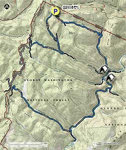
Trail Notes: All the trails in the Laurel Fork area are blue blazed. In conjunction with the USDA Forest Service HikingUpward.com reblazed the Locust Spring Run, Locust Spring Run Spur, and Slabcamp Run trails in June 2007.

From the right bottom of the picnic area start down the the Locust Spring Run Trail as it heads through old growth forest for 1.2 miles before arriving at the Buck Run Connecter Trail. Turn right, cross the run, then immediately turn left downhill remaining on the blue blazed Locust Spring Run Trail. Cross over the run two more times before crossing a small side stream and passing an old wooden trail sign in 0.3 miles. In another 0.2 miles cross the run again and arrive at the intersection of the Locust Spring Run Spur Trail.

Turn right very steeply uphill on the Locust Spring Run Spur Trail for 100 yards, then stay right as the trail follows an old forestry road. Pass a beaver dam downhill on the right in 1.1 miles, and in another 0.1 miles turn left uphill following the blues blazes. In 0.1 miles arrive at the ridge, and intersection of the Slabcamp Run Trail and FS106.

Turn left on gravel FS106 and follow it for 2.0 miles to the four way intersection of FS57 and FS58. Stay left on FS106 for another 0.1 miles to the junction of the Bearwallow Run Trail and a forestry gate. Turn left downhill on the Bearwallow Run Trail and in 2.0 miles be alert as the Bearwallow Run Trail turns left downhill staying closer to the stream. Continue along the trail for another 0.7 miles where it ends at the intersection of the Laurel Fork Trail and Laurel Fork.

Note: The Laurel Fork Trail is hard to follow in places and there are few blue blazes.

Turn left on the Laurel Fork Trail and immediately cross Bearwallow Run. Turn left uphill for 25 yards where the trail turns back to the right. Continue along the the trail as it follows the left bank of Laurel Fork and passes a small camping area in 1.0 miles. From this point the trail becomes harder to follow before you have to ford Laurel Fork in another 1.2 miles. There will be a large area of rhododendron on the opposite bank, and no blazes marking the crossing point as of July 2006. The crossing point long/lat is: N38 33.165 W79 36.816

After fording Laurel Fork turn left on the trail through a Rhododendron tunnel for 0.1 miles, cross a small stream, then reach the intersection of the Christian Run Trail. Continue straight on the Laurel Fork Trail for another 0.5 miles, and passing a rocky section along the river bank before arriving at the intersection of the Slabcamp Run Trail.

Turn right staying on the Laurel Fork Trail and in 200 yards there is a large campsite. 250 yards past the campsite ford Laurel Fork for the last time, and in another 0.1 miles cross Locust Spring Run before arriving at the intersection of the Locust Spring Run Trail and another large camping area.

Continue straight on the Buck Run Trail as it climbs through the valley. Cross the run in 1.5 miles, then cross back in another 200 yards where someone has set three logs together as a makeshift footbridge. Turn left after crossing the run where a rock cairn marks the trail. The trail makes several switchbacks as it climbs the mountain.

After the last switchback stay right where the trail now follows an old FS road. In 0.9 miles from the last switchback pass a wetland area on the right, then continue through a red pine stand before reaching the intersection of the Buck Run Connector Trail. Turn right on the Buck Run Trail and in 0.4 miles arrive at FR142. Turn left for the remaining 30 yards to the Locust Spring Picnic area and hike start point.

Explore 37 trails near Blue Grass, VA
  1. Parking

    38.584079, -79.640907
  2. Main Trailhead

    38.584645, -79.641523
No community routes found. To add your own hike as a Community Route for this Trail guide, leave a Trip Report with an attached GPX file.

Hazards

Ticks - Lyme Disease More Info (CDC)
Snakes
Poison Ivy/Oak

Seasons

All

Blaze Color

Blue

Photo Albums

+ Add Photo Album

Upload your photos from the trail to help others know what to expect.

Trip Reports (Reviews)

Rated 3.77 out of 5 based on 13 ratings.
By: Steve O.
13.0 miles / 20.9 km
September 05, 2015
We did a shorter variation of the hike in the guide over Labor Day weekend. Day 1 we hiked in on the Buck Run trail and stayed at the large campsite at the base of Locust Spring run. Beautiful site right on the river! Day 2 we did a day hike down Laurel Fork and up Cold Spring Run and back down Christian run and back to camp. Some good campsites along Laurel Fork and great fishing holes. Too bad I didn't bring my fishing pole. Warning, the Cold Spring and Christian Run trails were dense in stinging nettles. Ouch. They can be easily removed with the swipe of your walking stick but this made the hike less enjoyable and much harder than it would have otherwise been. I cleared as much of the trail as I could which took time. At the top of Cold Spring Run trail we hiked along a ridge that would have provided awesome views if the leaves on the trees weren't there. Should do this hike in the fall or winter for the views. The large meadow at the intersection of Cold Spring and Christian Run was absolutely spectacular bursting in yellows and full of honey bees. Day 3 we hiked out Locust Spring Run trail back to the parking area. The bottom half of the trail was filled with nettles. The upper half was spectacular in the pine forests. Overall the entire weekend we only saw one other couple. Despite some poor trail conditions (downed trees, nettles), this hike was awesome and highly recommended. We removed some trash we found at our campsite but otherwise it was cleaner than some sites we've been to. If you like solitude in a diverse and spectacular natural setting, give this hike a try.
Legacy Review
By: Chill Hiker
13.0 miles / 20.9 km
July 26, 2014
I've hiked this area numerous times, although always skipped this hike because the lack of views and my choice of hiking partners. Well, this weekend I was able to convince someone they didn't need huge views to have a rewarding trip, and not long into the hike, he fully agreed. First thing is first - Wilderness Areas: Wilderness areas are not national parks or national forests. Here's their legal definition: "A wilderness, in contrast with those areas where man and his own works dominate the landscape, is hereby recognized as an area where the earth and its community of life are untrammeled by man, where man himself is a visitor who does not remain." Therefore blazed trails are really, really rare. These areas aren't for you every day hiker but one who is prepared for any situation and is skilled in navigation and general woodsmanship. Additionally, there tends to be no trail maintenance, no infrastructure, and no people... it's the best! Trail Notes: 1. This is a great entry level Wilderness because of the abundant blazes marking the trails. I've hiked many, many wildernesses, and this is the easiest navigation I've ever had. Yes, all the blazes are the same color, but the trails for the most part follow old roads and runs, making it fairly easy to navigate. 2. There are a lot of Timber Rattlesnakes. I came up on one who was still digesting a nice meal, and so with his lethargy he was no concern. Down on the Laurel trail though, I came across a very aggressive one who coiled instead of striking as I barely missed him. My view of him was very short lived, as I was able to jump out of his reach. I've hiked a lot, and never had such a close scare with any animal (not to say I haven't encountered many, but this guy would've had me down for the count had he struck and I believe I was just too close for him to instinctually strike luckily he chose flight no fight) 3. People - we saw people on one occasion, and they were driving down the service road, and stopped to ask how "to get out of wherever we are". Additionally, I normally have a bag full of other people's garbage on trips this time I didnt find anything other than cigg butts! 4. The crossing of laurel fork is now marked very very well with a big cairn on each side. Just follow the blazes and you cant miss it 5. There are signs warning of the water not being tested, recommending chemicals or boiling. I used a sawyer squeeze filter and neither I nor my buddy had any problems
Legacy Review
By: euphgal
13.0 miles / 20.9 km
June 28, 2014
We wanted to do part of this trail as an out and back starting at the Laurel Fork Campground. It was awful. Unmarked and unmaintained. We gave up after about mile 2 when it was just a large patch of briars and raspberry bushes. There are so many other wonderful hikes in the area (try Chimney Top!) it's not worth the hassle of no view and prickers.
Legacy Review

Weather Forecast

In Blue Grass, VA

Explore Hiking Trails

You May Also Like

New York's Best Waterfalls - Whether you're planning a day hike, roadside stop, or a leisurely short walk, this guide provides hikers, travelers, and locals alike with 63 different locations to over 100 scenic waterfalls to help plan your next adventure!
Explore

New York's Best Waterfalls

Whether you're planning a day hike, roadside stop, or a leisurely short walk, this guide provides hikers, travelers, and locals alike with 63 different locations to over 100 scenic waterfalls to help plan your next adventure!

Read
25 Best Day Hikes in North Carolina - Discover the top 25 best day hikes in North Carolina, from breathtaking waterfalls to mountain peaks. Explore hidden gems, scenic views, and trails suitable for all skill levels, perfect for your next outdoor adventure.
Explore

25 Best Day Hikes in North Carolina

Discover the top 25 best day hikes in North Carolina, from breathtaking waterfalls to mountain peaks. Explore hidden gems, scenic views, and trails suitable for all skill levels, perfect for your next outdoor adventure.

Read

Before you boogie...

Find our trail guides useful? Consider becoming a Supporter to unlock perks!

MyHikes is an indie platform that makes exploring public trails easier for everyone. The platform has no investors, no ads, and is owned and operated by one person, Dave Miller. Dave has personally mapped and written over 1,800 trail guides on MyHikes for the public to explore. MyHikes has helped millions outdoor enthusiasts plan their next adventure.

But it takes a lot of time 🕦, money 💰, work, and espresso shots ☕ to run MyHikes, including hiking , mapping , writing , and publishing new trails with high-quality (accurate) information... along with software engineering (coding) the platform like building new features, website and mobile app development (iOS and Android), site maintainance . and much much more.

Supporters unlock website and mobile app perks with an annual one-time payment of $25 (you renew) 😎👍. Or you can simply make a Donation of your choice. Otherwise, you can support us by telling your friends about MyHikes - both quick and free 🎉

Admin user profile picture

Dave Miller
MyHikes Founder