Loading...

🎉 Enjoy a Free 7-Day Supporter Trial and Unlock Exclusive Perks — No Credit Card Required. Learn more.

Lakeside Loop

Directions
Map
Pictures
Send to App
Distance:
0.3 Miles / 0.5 km
Type:
Loop
Difficulty:
Easy
Time to Hike:
~9 minutes
Features:
Surface Type:
Dirt
Park:
Lakeside State Park
Town:
Waterport, New York
Directions:
43.367484, -78.243026
Added:
September 27, 2022
Updated:
November 10, 2022
Copy Trail Link Hiking this trail? Send a friend or family member a link to this trail guide for your own safety. Hike at your own risk (disclaimer)
Loading...
Loading...
10'

Total Change
11'

Ascent
11'

Descent

Download the Trail Route for Offline Use

Supporters get exclusive access to download trail routes to the MyHikes app for offline use. Stay prepared on your adventure, even without an internet connection! Become a Supporter today to unlock this feature and hike with confidence.

Send to App

Lakeside Loop

The Lakeside Loop at Lakeside State Park near Waterport, New York is an easy 0.3-mile loop walk that leads down to the lakeside bluffs of Lake Ontario and features views.

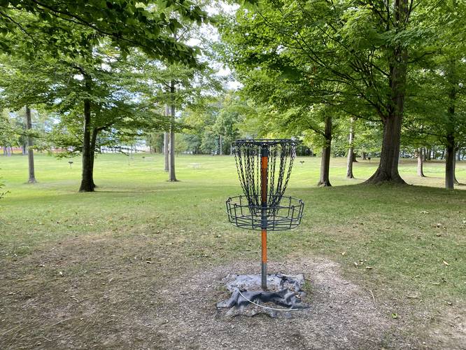
This short hike does not follow any defined trail, but rather follows disc golf course goal posts along the hillside and down to the waterfront.

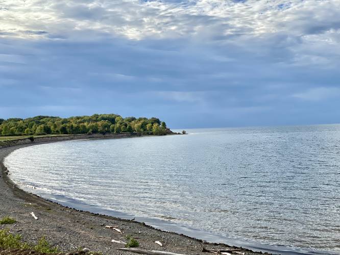
Lake Ontario View - Mile 0.15
At mile 0.15, at the lake shore, hikers get a nice view of Lake Ontario from the top of the lake shore's bluff. As of September, 2022, the waterfront was under construction in certain areas and had orange fencing around the bluffs - likely to keep people out temporarily.

Note that due to timing, we had to leave after just 0.3-miles of walking; however, there's plenty of unmarked paths hikers can take from here if they follow the lake shore heading west.

Parking & Fees
Visitors will find a very large parking lot at the coordinates provided. There's a $10 fee as of September, 2022 to enter the park for out-of-state plates.

Pets
Dogs are allowed if leashed and their waste must be carried out by the hiker.
Explore 3 trails near Waterport, NY
  1. Parking

    43.367484, -78.243026
  2. Main Trailhead

    43.367555, -78.243074
  3. Disc golf course

    43.368328, -78.243125
    Disc golf course
  4. View of Lake Ontario

    43.369033, -78.244781
    View of Lake Ontario
No community routes found. To add your own hike as a Community Route for this Trail guide, leave a Trip Report with an attached GPX file.

Hazards

Ticks - Lyme Disease More Info (CDC)

Seasons

All

Weather Forecast

In Waterport, NY

Explore Hiking Trails

You May Also Like

Colorado's Million Dollar Highway - Plan a day's drive adventure along the iconic Million Dollar Highway in Colorado. Explore the best short trails, roadside stops, waterfalls, vistas, ghost towns, and hot springs within a ~6 hour road trip.
Explore

Colorado's Million Dollar Highway

Plan a day's drive adventure along the iconic Million Dollar Highway in Colorado. Explore the best short trails, roadside stops, waterfalls, vistas, ghost towns, and hot springs within a ~6 hour road trip.

Read
Glacier's Going-to-the-Sun Road - Discover the breathtaking beauty of Glacier National Park along the iconic Going-to-the-Sun Road. From stunning roadside stops to picturesque waterfalls and vistas, this engineering marvel offers endless opportunities for exploration.
Explore

Glacier's Going-to-the-Sun Road

Discover the breathtaking beauty of Glacier National Park along the iconic Going-to-the-Sun Road. From stunning roadside stops to picturesque waterfalls and vistas, this engineering marvel offers endless opportunities for exploration.

Read
New York's Best Waterfalls - Whether you're planning a day hike, roadside stop, or a leisurely short walk, this guide provides hikers, travelers, and locals alike with 63 different locations to over 100 scenic waterfalls to help plan your next adventure!
Explore

New York's Best Waterfalls

Whether you're planning a day hike, roadside stop, or a leisurely short walk, this guide provides hikers, travelers, and locals alike with 63 different locations to over 100 scenic waterfalls to help plan your next adventure!

Read

Before you boogie...

Find our trail guides useful? Consider becoming a Supporter to unlock perks!

MyHikes is an indie platform that makes exploring public trails easier for everyone. The platform has no investors, no ads, and is owned and operated by one person, Dave Miller. Dave has personally mapped and written over 1,800 trail guides on MyHikes for the public to explore. MyHikes has helped millions outdoor enthusiasts plan their next adventure.

But it takes a lot of time 🕦, money 💰, work, and espresso shots ☕ to run MyHikes, including hiking , mapping , writing , and publishing new trails with high-quality (accurate) information... along with software engineering (coding) the platform like building new features, website and mobile app development (iOS and Android), site maintainance . and much much more.

Supporters unlock website and mobile app perks with an annual one-time payment of $25 (you renew) 😎👍. Or you can simply make a Donation of your choice. Otherwise, you can support us by telling your friends about MyHikes - both quick and free 🎉

Admin user profile picture

Dave Miller
MyHikes Founder