The Lackawanna Rail Trail in Elmira, New York is an easy universally-accessible 2.1-mile out-and-back walk that features interesting street art, graffiti, and views of Newtown Creek.
Trails
This walk follows just a small section of the Lackawanna Rail Trail.
Universal Access
This trail is paved and universally accessible. No Winter maintenance between November 1st and May 1st.
Walk
This walk begins at the main parking lot for the Lackawanna Rail Trail located on the south side of East Water Street just West of I-86. The trailhead is on the East side of the parking lot where the paved path begins. Follow this path to head under the East Water Street bridge -- along the way are some colorful street art murals and graffiti.
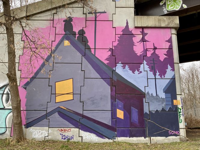
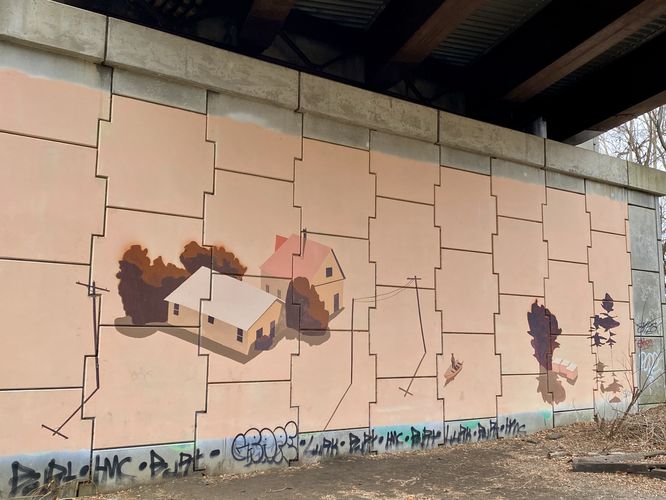
Elmira Nightscape & Symmetric Neighborhood murals by SOMO - Mile 0.07
Within several-hundred feet along the trail are a couple of murals by a street artist by the tag name SOMO. The first is a nightscape scene of two houses with two silhouettes sitting on a roof together. In the background are evergreens of varying shades of color, under a moon. It has no name, so I labeled it "Elmira Nightscape". Just around the corner is another mural by SOMO -- this one appears to bend the mind a bit with symmetric reflections of telephone poles, a person and a rowboat, and some small buildings. In the center are two buildings as seen from a top-down view. No name was given so I labeled this "Symmetric Neighborhood" as it depicts a lot of symmetry within the mural.
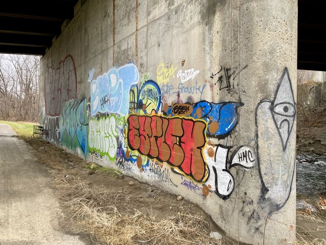
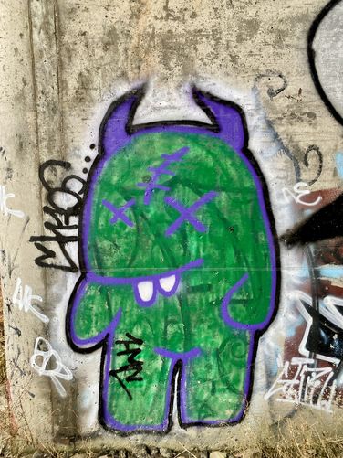
Bridge Graffiti - Mile 0.12
Just beyond the murals are a bunch of random tags of graffiti, some of which are really colorful. Some are silly, like a Halloween-style vampire.
As of December 2023, the bridge that spans Newtown Creek (heading south) is closed, hence this walk leads North at the junction under the bridge overpass. After taking a left-hand turn to head North, the trail runs along Newtown Creek for the remainder of this segment of the Lackawanna Rail Trail.
Abandoned Unhoused Camps - Mile 0.35 to 0.5
Between miles 0.35 and 0.5 are old encampments from folks who've found shelter along this trail. Unfortunately I personally heard of a story of some folks being harassed along this trail, during warm months, so please be mindful and careful when walking through this section. As of December 2023, there were the remains of camps, so just trash littered in the woods, but that could change from time to time. Just stating this so walkers or bikers are mindful.
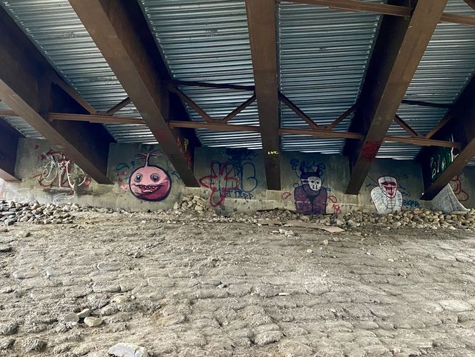
Bridge Graffiti - Mile 0.55
The trail will pop out of the wooded section to reach a bridge underpass at East Church Street. Here, walkers will find more silly and colorful graffiti tags.
Walk to Turn-Around Points - Mile 0.55 to 1.1
From East Church Street bridge, the walk to this GPS track's end is pleasant and scenic. The walk leads along Newtown Creek with views of the creek along the way. Once you reach this track's end-point, you're about to walk further into Elmira, which becomes less scenic as the trail strays away from the creek. If you look behind, facing South, you'll find both the trail and creek as they bend around the corner with the backdrop of Elmira's hills behind -- providing a scenic spot to turn-around and head back to parking.
The walk back follows the identical path in but is mostly downhill. Enjoy the graffiti and murals on your way out to complete this 2.1-mile out-and-back walk.
Parking
Walkers will find a massive parking lot at the coordinates provided, located along the South side of East Water Street, just West of I-86 in Elmira.
Pets
Dogs are allowed only if leashed and must be cleaned up after.
Biking
Biking is allowed on this trail. In fact this is a popular biking trail in the Elmira area.
Trails
This walk follows just a small section of the Lackawanna Rail Trail.
Universal Access
This trail is paved and universally accessible. No Winter maintenance between November 1st and May 1st.
Walk
This walk begins at the main parking lot for the Lackawanna Rail Trail located on the south side of East Water Street just West of I-86. The trailhead is on the East side of the parking lot where the paved path begins. Follow this path to head under the East Water Street bridge -- along the way are some colorful street art murals and graffiti.
Elmira Nightscape & Symmetric Neighborhood murals by SOMO - Mile 0.07
Within several-hundred feet along the trail are a couple of murals by a street artist by the tag name SOMO. The first is a nightscape scene of two houses with two silhouettes sitting on a roof together. In the background are evergreens of varying shades of color, under a moon. It has no name, so I labeled it "Elmira Nightscape". Just around the corner is another mural by SOMO -- this one appears to bend the mind a bit with symmetric reflections of telephone poles, a person and a rowboat, and some small buildings. In the center are two buildings as seen from a top-down view. No name was given so I labeled this "Symmetric Neighborhood" as it depicts a lot of symmetry within the mural.
Bridge Graffiti - Mile 0.12
Just beyond the murals are a bunch of random tags of graffiti, some of which are really colorful. Some are silly, like a Halloween-style vampire.
As of December 2023, the bridge that spans Newtown Creek (heading south) is closed, hence this walk leads North at the junction under the bridge overpass. After taking a left-hand turn to head North, the trail runs along Newtown Creek for the remainder of this segment of the Lackawanna Rail Trail.
Abandoned Unhoused Camps - Mile 0.35 to 0.5
Between miles 0.35 and 0.5 are old encampments from folks who've found shelter along this trail. Unfortunately I personally heard of a story of some folks being harassed along this trail, during warm months, so please be mindful and careful when walking through this section. As of December 2023, there were the remains of camps, so just trash littered in the woods, but that could change from time to time. Just stating this so walkers or bikers are mindful.
Bridge Graffiti - Mile 0.55
The trail will pop out of the wooded section to reach a bridge underpass at East Church Street. Here, walkers will find more silly and colorful graffiti tags.
Walk to Turn-Around Points - Mile 0.55 to 1.1
From East Church Street bridge, the walk to this GPS track's end is pleasant and scenic. The walk leads along Newtown Creek with views of the creek along the way. Once you reach this track's end-point, you're about to walk further into Elmira, which becomes less scenic as the trail strays away from the creek. If you look behind, facing South, you'll find both the trail and creek as they bend around the corner with the backdrop of Elmira's hills behind -- providing a scenic spot to turn-around and head back to parking.
The walk back follows the identical path in but is mostly downhill. Enjoy the graffiti and murals on your way out to complete this 2.1-mile out-and-back walk.
Parking
Walkers will find a massive parking lot at the coordinates provided, located along the South side of East Water Street, just West of I-86 in Elmira.
Pets
Dogs are allowed only if leashed and must be cleaned up after.
Biking
Biking is allowed on this trail. In fact this is a popular biking trail in the Elmira area.