The Kinzua Creek Trail at Kinzua Bridge State Park in Kane, Pennsylvania is a difficult 1.2-mile out-and-back trail that leads to the bottom of Kinzua Gorge with stunning views of the wreckage of the Kinzua Bridge.
The trailhead can be found directly behind the visitor center and follows a gravel path downhill, first to a wooden platform lookout point of the Kinzua Bridge and Kinzua Gorge. After stopping at the wooden lookout, the trail continues downhill at a steep grade for roughly 0.4-miles until reaching the bottom of Kinzua Gorge. This steep section of the trail includes large rocks used for steps; however, the gravel tends to sit on top of parts of these rock steps - making them somewhat slippery, so wearing proper hiking footwear is recommended on this trail.
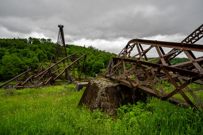
Follow the signs with arrows that state "Trail" and always stay on the trail. Upon reaching the bottom of the Kinzua Gorge, there will be a wooden footbridge that crosses Kinzua Creek. Cross the creek and you'll find a stunning view of the remaining Kinzua Bridge high above you. The trail continues uphill so you can get a view of the rest of the gorge and valley; however, you do not need to follow the trail for very far to get a decent view of the wrecked Kinzua Bridge.
Lookout Point: There's a lookout point just 0.1-miles into the trail, directly behind the visitor center. You can also find a nice lookout point on the opposite side of Kinzua Creek after following the trail to the bottom of Kinzua Gorge.
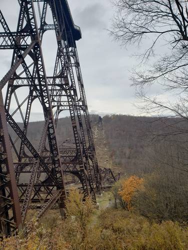
History: The Kinzua Viaduct was once the longest and tallest railroad structure at 2,053 feet long and 301 feet high until it was partially destroyed by a tornado during 2003. The land was reinvented in 2011 as a state park for visitors and hikers to explore.
Pets: Dogs are allowed on this trail on leash and their waste must be carried out.
Water source: If you use a water filter, you can refill at Kinzua Creek.
The trailhead can be found directly behind the visitor center and follows a gravel path downhill, first to a wooden platform lookout point of the Kinzua Bridge and Kinzua Gorge. After stopping at the wooden lookout, the trail continues downhill at a steep grade for roughly 0.4-miles until reaching the bottom of Kinzua Gorge. This steep section of the trail includes large rocks used for steps; however, the gravel tends to sit on top of parts of these rock steps - making them somewhat slippery, so wearing proper hiking footwear is recommended on this trail.
Follow the signs with arrows that state "Trail" and always stay on the trail. Upon reaching the bottom of the Kinzua Gorge, there will be a wooden footbridge that crosses Kinzua Creek. Cross the creek and you'll find a stunning view of the remaining Kinzua Bridge high above you. The trail continues uphill so you can get a view of the rest of the gorge and valley; however, you do not need to follow the trail for very far to get a decent view of the wrecked Kinzua Bridge.
Lookout Point: There's a lookout point just 0.1-miles into the trail, directly behind the visitor center. You can also find a nice lookout point on the opposite side of Kinzua Creek after following the trail to the bottom of Kinzua Gorge.
History: The Kinzua Viaduct was once the longest and tallest railroad structure at 2,053 feet long and 301 feet high until it was partially destroyed by a tornado during 2003. The land was reinvented in 2011 as a state park for visitors and hikers to explore.
Pets: Dogs are allowed on this trail on leash and their waste must be carried out.
Water source: If you use a water filter, you can refill at Kinzua Creek.