The King Canyon & Gould Mine Loop Trail at Saguaro National Park in Tucson, Arizona is a moderate 2.6 mile hike that takes you across three separate trails at the park - the King Canyon Trail, Sendero Esperanza Trail, and the Gould Mine Trail.
The hike starts off at the main parking lot for the King Canyon Trail - stay right at the immediate fork right after the trailhead; otherwise, you'll end up hiking up King Canyon Wash instead. Follow the King Canyon Trail for 0.9 miles gradually uphill towards the Sendero Esperanza Trail. The King Canyon Trail can be fairly rocky, so watch your step.
After the first trail junction, follow the Esperanza Trail for 0.4 miles before you reach another trail junction for the Gould Mine Trail. Check out Gould Mine before heading back; however, the hike downhill and back to parking along the Gould Mine Trail is fairly easy and less rocky than the King Canyon Trail.
Please note that when you reach the end of the Gould Mine Trail, the southern trailhead is technically located on the road - not at the parking lot. You'll need to hike down the road about 0.1 miles to find a shortcut back to the parking lot.
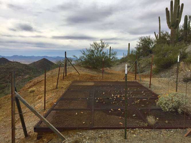
Gould Mine: Before heading back to parking along the Gould Mine Trail, continue along the Sendero Esperanza Trail to reach the top of the old mine, which lies about 0.1 miles uphill from the junction. There's a metal grate with a barbed-wire fence surrounding it as this old mine shaft is 300 feet deep. Also note that the cliff created by the tailings from the mine can be dangerous as well, so stay clear of the edge of the tailings.
Parking: Parking can be found at the coordinates provided; however, this is a popular lot for hikers to reach Wasson Peak, so prepare for the lot to be full. You can also park across the street at the museum parking lot for free.
Trail traffic: Despite this being a popular day hike, the loop can generally feel pretty empty as many day hikers head up to Wasson Peak or meander around this loop or the King Canyon Wash - a trail that runs below the King Canyon Trail.
The hike starts off at the main parking lot for the King Canyon Trail - stay right at the immediate fork right after the trailhead; otherwise, you'll end up hiking up King Canyon Wash instead. Follow the King Canyon Trail for 0.9 miles gradually uphill towards the Sendero Esperanza Trail. The King Canyon Trail can be fairly rocky, so watch your step.
After the first trail junction, follow the Esperanza Trail for 0.4 miles before you reach another trail junction for the Gould Mine Trail. Check out Gould Mine before heading back; however, the hike downhill and back to parking along the Gould Mine Trail is fairly easy and less rocky than the King Canyon Trail.
Please note that when you reach the end of the Gould Mine Trail, the southern trailhead is technically located on the road - not at the parking lot. You'll need to hike down the road about 0.1 miles to find a shortcut back to the parking lot.
Gould Mine: Before heading back to parking along the Gould Mine Trail, continue along the Sendero Esperanza Trail to reach the top of the old mine, which lies about 0.1 miles uphill from the junction. There's a metal grate with a barbed-wire fence surrounding it as this old mine shaft is 300 feet deep. Also note that the cliff created by the tailings from the mine can be dangerous as well, so stay clear of the edge of the tailings.
Parking: Parking can be found at the coordinates provided; however, this is a popular lot for hikers to reach Wasson Peak, so prepare for the lot to be full. You can also park across the street at the museum parking lot for free.
Trail traffic: Despite this being a popular day hike, the loop can generally feel pretty empty as many day hikers head up to Wasson Peak or meander around this loop or the King Canyon Wash - a trail that runs below the King Canyon Trail.