The Kildoo Trail in McConnell's Mill State Park in Portersville, Pennsylvania is an easy 1.3-mile one-way trail that run along Slippery Rock Creek and features beautiful scenery and a moderate-sized waterfall.
This recording starts next to the covered bridge and follows the Kildoo Trail along the eastern side of Slippery Rock Creek, ending at Eckert Bridge Road - approximately 1.3 miles one-way.
This trail has numerous small waterfalls (1-2 feet tall) that trickle down to the creek from the adjacent hillside. Along Slippery Rock Creek are plenty of large boulders to sit on and watch the creek flow by.
Hikers can take this trail back for a ~2.6-mile out-and-back hike or take the Slippery Rock Gorge Trail back to the covered bridge for a hike of a similar distance.
Parking
Parking can now be found at the upper parking lot at the junction of McConnells Mill Road and Kildoo Road. Hikers will have to follow the trail from the parking lot, down to the covered bridge. This trail is shown in the GPS data since the trail was tracked back when parking was available next to the covered bridge.
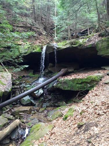
Kildoo Falls Waterfall
Closer to the Eckert Bridge Road trailhead is a moderate-sized waterfall, Kildoo Falls, that cascades approximately 10-feet down the creek. This waterfall and creek sits to the east of Slipper Rock Creek, but the falls can be seen from the main trail, so it's not hard to miss.
Pets
Dogs are allowed if leashed and their waste must be carried out by the hiker.
Views
The views/lookout mentioned here is not an overlook, but just the view from Slippery Rock Creek up to the covered bridge. There are not many covered bridges in western Pennsylvania, hence the 'views'.
This recording starts next to the covered bridge and follows the Kildoo Trail along the eastern side of Slippery Rock Creek, ending at Eckert Bridge Road - approximately 1.3 miles one-way.
This trail has numerous small waterfalls (1-2 feet tall) that trickle down to the creek from the adjacent hillside. Along Slippery Rock Creek are plenty of large boulders to sit on and watch the creek flow by.
Hikers can take this trail back for a ~2.6-mile out-and-back hike or take the Slippery Rock Gorge Trail back to the covered bridge for a hike of a similar distance.
Parking
Parking can now be found at the upper parking lot at the junction of McConnells Mill Road and Kildoo Road. Hikers will have to follow the trail from the parking lot, down to the covered bridge. This trail is shown in the GPS data since the trail was tracked back when parking was available next to the covered bridge.
Kildoo Falls Waterfall
Closer to the Eckert Bridge Road trailhead is a moderate-sized waterfall, Kildoo Falls, that cascades approximately 10-feet down the creek. This waterfall and creek sits to the east of Slipper Rock Creek, but the falls can be seen from the main trail, so it's not hard to miss.
Pets
Dogs are allowed if leashed and their waste must be carried out by the hiker.
Views
The views/lookout mentioned here is not an overlook, but just the view from Slippery Rock Creek up to the covered bridge. There are not many covered bridges in western Pennsylvania, hence the 'views'.