Loading...

๐ŸŽ‰ Enjoy a Free 7-Day Supporter Trial and Unlock Exclusive Perks โ€” No Credit Card Required. Learn more.

Kilauea Lighthouse Trail

Directions
Map
Pictures
Send to App
Distance:
0.4 Miles / 0.6 km
Type:
Out-and-Back
Difficulty:
Easy
Time to Hike:
~12 minutes
Features:
Surface Type:
Paved
Park:
Kilauea Point National Wildlife Refuge
Town:
Kilauea, Hawaii
Directions:
22.229092, -159.402388
Added:
June 26, 2022
Updated:
July 06, 2022
Copy Trail Link Hiking this trail? Send a friend or family member a link to this trail guide for your own safety. Hike at your own risk (disclaimer)
Loading...
Loading...
37'

Total Change
37'

Ascent
33'

Descent

Download the Trail Route for Offline Use

Supporters get exclusive access to download trail routes to the MyHikes app for offline use. Stay prepared on your adventure, even without an internet connection! Become a Supporter today to unlock this feature and hike with confidence.

Send to App

Kilauea Lighthouse Trail

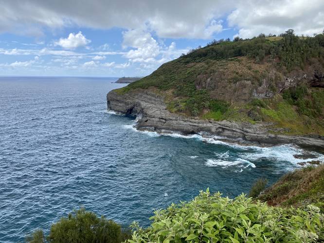
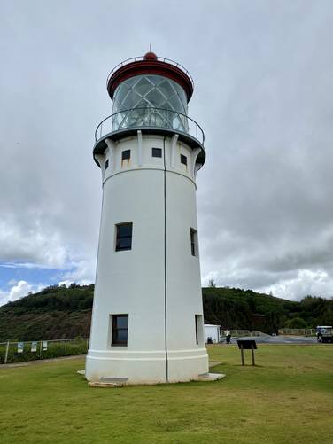
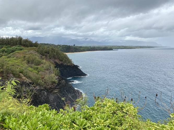
The Kilauea Lighthouse Trail at the Kilauea Point National Wildlife Refuge in Kilauea, Hawaii (Kauai) is an easy 0.4-mile out-and-back or loop trail that features the iconic Kilauea Lighthouse and scenic views of Kauai's northern shoreline.

Along the trail, visitors can learn about the history and wildlife within the refuge. According to signage along the trail, in 1912 when construction began, there were no roads on Kauai, so everything was shipped by boat. A retaining wall was built on the west side of the point to allow the transferring of materials from those boats, which still stands today and is a fairly obvious soar thumb on the coastline, if you can locate it.

Parking, Reservations, and Fees
Hikers will need a reservation to park at the lighthouse. If you show up early enough, they may allow you in without a reservation. Note that there's an entrance fee to get in, which is $10 per adult (16+) as of June, 2022.

Pets
Dogs are not allowed at the park.

Respecting the Land
Hawaiian land is considered sacred to native Hawaiians and many locals, so please stay on-trail, take nothing but photos, and leave nothing but footprints. Respect the locals - don't stay for long and have a backup hike planned in case the parking lot is full.
Explore 51 trails near Kilauea, HI
  1. Parking

    22.229092, -159.402388
  2. Main Trailhead

    22.229501, -159.40213
  3. View east along Kauai's coast with sea caves and wild birds on the rocky ledges

    22.231019, -159.401869
    View east along Kauai's coast with sea caves and wild birds on the rocky ledges
  4. Kilauea Lighthouse

    22.231833, -159.402022
    Kilauea Lighthouse
  5. View towards Hanalei Bay and Kauai's northern coast with mountains in the distance

    22.231503, -159.402114
    View towards Hanalei Bay and Kauai's northern coast with mountains in the distance
No community routes found. To add your own hike as a Community Route for this Trail guide, leave a Trip Report with an attached GPX file.

Seasons

All

Trip Reports

Trail Guide By:
Admin user profile picture
0.4 miles / 0.6 km
0.4 miles / 0.6 km
June 25, 2022
Hiking
Preview of the MyHikes mobile app interface

Track, Log, and Explore Hikes with the MyHikes App

Shop Landscape Prints
Shop our landscape prints from Kauai, Hawaii

Weather Forecast

In Kilauea, HI

Explore Hiking Trails

You May Also Like

Colorado's Million Dollar Highway - Plan a day's drive adventure along the iconic Million Dollar Highway in Colorado. Explore the best short trails, roadside stops, waterfalls, vistas, ghost towns, and hot springs within a ~6 hour road trip.
Explore

Colorado's Million Dollar Highway

Plan a day's drive adventure along the iconic Million Dollar Highway in Colorado. Explore the best short trails, roadside stops, waterfalls, vistas, ghost towns, and hot springs within a ~6 hour road trip.

Read
Glacier's Going-to-the-Sun Road - Discover the breathtaking beauty of Glacier National Park along the iconic Going-to-the-Sun Road. From stunning roadside stops to picturesque waterfalls and vistas, this engineering marvel offers endless opportunities for exploration.
Explore

Glacier's Going-to-the-Sun Road

Discover the breathtaking beauty of Glacier National Park along the iconic Going-to-the-Sun Road. From stunning roadside stops to picturesque waterfalls and vistas, this engineering marvel offers endless opportunities for exploration.

Read
New York's Best Waterfalls - Whether you're planning a day hike, roadside stop, or a leisurely short walk, this guide provides hikers, travelers, and locals alike with 63 different locations to over 100 scenic waterfalls to help plan your next adventure!
Explore

New York's Best Waterfalls

Whether you're planning a day hike, roadside stop, or a leisurely short walk, this guide provides hikers, travelers, and locals alike with 63 different locations to over 100 scenic waterfalls to help plan your next adventure!

Read

Before you boogie...

Find our trail guides useful? Consider becoming a Supporter to unlock perks!

MyHikes is an indie platform that makes exploring public trails easier for everyone. The platform has no investors, no ads, and is owned and operated by one person, Dave Miller. Dave has personally mapped and written over 1,800 trail guides on MyHikes for the public to explore. MyHikes has helped millions outdoor enthusiasts plan their next adventure.

But it takes a lot of time ๐Ÿ•ฆ, money ๐Ÿ’ฐ, work, and espresso shots โ˜• to run MyHikes, including hiking , mapping , writing , and publishing new trails with high-quality (accurate) information... along with software engineering (coding) the platform like building new features, website and mobile app development (iOS and Android), site maintainance . and much much more.

Supporters unlock website and mobile app perks with an annual one-time payment of $25 (you renew) ๐Ÿ˜Ž๐Ÿ‘. Or you can simply make a Donation of your choice. Otherwise, you can support us by telling your friends about MyHikes - both quick and free ๐ŸŽ‰

Admin user profile picture

Dave Miller
MyHikes Founder