Loading...

🍂 Prep for Fall! Unlock exclusive features to plan your perfect late-summer and autumn hikes — become a Supporter today. Learn more.

Keys Gap and David Lesser Shelter Hike

Directions
Map
Pictures
Send to App
Distance:
6.2 Miles / 10.0 km
Type:
Out-and-Back
Difficulty:
Moderate
Time to Hike:
3 hours, ~6 minutes
Features:
Appalachian Trail hike
Surface Type:
Dirt
Town:
Keys Gap, Virginia
Directions:
39.261801, -77.762407
Added:
April 03, 2025
Updated:
April 06, 2025
Guide by:
Copy Trail Link Hiking this trail? Send a friend or family member a link to this trail guide for your own safety. Hike at your own risk (disclaimer)
Loading...
Loading...
603'

Total Change
763'

Ascent
758'

Descent

Download the Trail Route for Offline Use

Supporters get exclusive access to download trail routes to the MyHikes app for offline use. Stay prepared on your adventure, even without an internet connection! Become a Supporter today to unlock this feature and hike with confidence.

Send to App

Key Takeaways

  • The Keys Gap to David Lesser Shelter hike is a less crowded 6.2-mile section of the Appalachian Trail in Loudoun County, Virginia.
  • The trail features a gradual ascent to a ridge with views, passing a transmission tower and eventually leading to the David Lesser Shelter with camping amenities.
  • The David Lesser Shelter is a popular overnight spot with a seasonal spring and camping area, so arriving early is recommended, especially during warmer months.

Keys Gap and David Lesser Shelter Hike

Keys Gap to the David Lesser shelter is one of the lesser utilized sections of the Appalachian Trail as it passes through Loudoun County Virginia. With the better know Raven Rocks to the south, and Loudoun Heights to the north, the Keys Gap/David Lesser Shelter hike is a nice alternative to the crowds. The David Lesser Shelter is a popular overnight campsite, with an adjacent tent camping area and picnic gazebo with swinging chair. If you plan on camping here make sure to arrive a little early as it is well utilized in the warmer months.
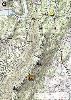
  • Mile 0.0 – From the parking area at Keys Gap join the Appalachian Trail (AT) at the far end of the parking area and information kiosk. Head south, immediately crossing VA-9. The first 0.5 miles of the AT can be muddy after rains. Follow the AT as it begins to ascend Blue Ridge.
  • Mile 1.0 – Pass a campsite on the left of the trail, and then continue uphill to the ridge.
  • Mile 1.23 – Arrive at the ridge, with Loudoun County to the east and Jefferson County to the west. The ridgeline is the boarder of Virginia and West Virginia. Continue along the ridge for another 0.44 miles where the AT crosses an old fire road.
  • Mile 1.67 – Climb to the top of a rise on the ridge.
  • Mile 2.02 – Pass a transmission tower on the right, with nice views of Loudoun valley when the leaves are off the trees. Pass around the west side of the ridge and descend slightly to the intersection of the blue blazed David Lesser Shelter Trail.
  • Mile 3.1 – Descend to the David Lesser Shelter. There is a separate sheltered chair swing next to the main shelter, as well as a large group campground 50 yards below the shelter. A seasonal spring is also located below and to the right of the shelter. Return to the AT and turn right to retrace your route back to Keys Gap.
  • Mile 6.2 - Arrive back at the Keys Gap Parking area.
Explore 32 trails near Keys Gap, VA
  1. Parking

    39.261801, -77.762407
  2. Main Trailhead

    39.261467, -77.762282
No community routes found. To add your own hike as a Community Route for this Trail guide, leave a Trip Report with an attached GPX file.

Hazards

Ticks - Lyme Disease More Info (CDC)
Snakes
Poison Ivy/Oak

Seasons

All

Blaze Color

White

Photo Albums

+ Add Photo Album

Upload your photos from the trail to help others know what to expect.

Trip Reports (Reviews)

Rated 3.5 out of 5 based on 6 ratings.
By: Lori
6.2 miles / 10.0 km
November 10, 2019
Perfect half day hike. Well marked trails, good parking. Enough people to feel safe but not so many to spoil the solitude. Leaves were down which improved the views. (Views better farther north at Harpers Ferry). Easy elevation, although the leaves occasionally concealed tricky rock spots.
Legacy Review
By: Ed Matthews
6.2 miles / 10.0 km
June 25, 2017
Nice little green tunnel hike after being off a month for an injured knee. Easy section of the AT. Views are just OK. This would be a much better hike when the leaves are down. Be extremely careful crossing route 9 at Keys Gap. There are no sightlines for either you or the motorists. Be sure to pop-in and visit the David Lesser shelter, a Hilton among AT shelters with its deck, deck seating, Adirondack chairs, and porch swing under a separate cooking shelter. The only downside to this shelter is that water is a long way down the hill. One thing to note is that the blue-blazed trail to the overlook forks. Avoid the temptation to take the right fork which looks much more heavily traveled. It dumps you in a scree field with no view at all. Take the left, much less traveled, fork to get out to where you want to be. https://mangiabeve.blogspot.com/2017/06/at-keys-gap-to-buzzard-rocks.html
Legacy Review
By: Sean
6.2 miles / 10.0 km
January 13, 2017
I enjoyed this hike. Great views as the leaves were off the trees. You would not see a lot in the distance in the summer, but it is still a nice hike. The description said it was muddy at the start -- I did not find much mud there but found more starting at the 1 mile mark. It was only in short stretches and not very deep, about one-half inch. I did fine wth my trail runners. Several downed big trees to climb over. Safety: RUN when you cross the highway. The road is hilly and curved, and traffic is fast. You do not see or hear vehicles -- and they do not see you -- until they are VERY close. Also, a sign on the bulletin board warns to leave NOTHING visible in vehicles, even chargers. It also says if you must leave a bag in the vehicle, open it up so would-be thieves can see it is just clothing or nothing valuable. Theft is clearly a problem here. While I was in the parking area before and after the hike I saw a total of three people just parked sitting in cars, smoking and looking around. I don't see that at other hike parking areas in this region. They could just be taking a break, but be careful anyway.
Legacy Review

Weather Forecast

In Keys Gap, VA

Explore Hiking Trails

You May Also Like

New York's Best Waterfalls - Whether you're planning a day hike, roadside stop, or a leisurely short walk, this guide provides hikers, travelers, and locals alike with 63 different locations to over 100 scenic waterfalls to help plan your next adventure!
Explore

New York's Best Waterfalls

Whether you're planning a day hike, roadside stop, or a leisurely short walk, this guide provides hikers, travelers, and locals alike with 63 different locations to over 100 scenic waterfalls to help plan your next adventure!

Read
25 Best Day Hikes in North Carolina - Discover the top 25 best day hikes in North Carolina, from breathtaking waterfalls to mountain peaks. Explore hidden gems, scenic views, and trails suitable for all skill levels, perfect for your next outdoor adventure.
Explore

25 Best Day Hikes in North Carolina

Discover the top 25 best day hikes in North Carolina, from breathtaking waterfalls to mountain peaks. Explore hidden gems, scenic views, and trails suitable for all skill levels, perfect for your next outdoor adventure.

Read

Before you boogie...

Find our trail guides useful? Consider becoming a Supporter to unlock perks!

MyHikes is an indie platform that makes exploring public trails easier for everyone. The platform has no investors, no ads, and is owned and operated by one person, Dave Miller. Dave has personally mapped and written over 1,800 trail guides on MyHikes for the public to explore. MyHikes has helped millions outdoor enthusiasts plan their next adventure.

But it takes a lot of time 🕦, money 💰, work, and espresso shots ☕ to run MyHikes, including hiking , mapping , writing , and publishing new trails with high-quality (accurate) information... along with software engineering (coding) the platform like building new features, website and mobile app development (iOS and Android), site maintainance . and much much more.

Supporters unlock website and mobile app perks with an annual one-time payment of $25 (you renew) 😎👍. Or you can simply make a Donation of your choice. Otherwise, you can support us by telling your friends about MyHikes - both quick and free 🎉

Admin user profile picture

Dave Miller
MyHikes Founder