Located on the north side of Snoqualmie Pass near North Bend, Washington sits the legendary Kendall Katwalk — an alpine ridge path, and part of the Pacific Crest Trail (PCT) — that was blasted directly into a steep granite cliff face and offers panoramic views into the Cascade Mountains.
The Kendall Katwalk Hike is a difficult 14.4-mile out-and-back hike within the Mt. Baker-Snoqulamie National Forest that traverses the steep-sloped Kendall Katwalk, passes alpine meadows, talus slopes, old growth forests, features panoramic alpine views, and leads to two lakes — Ridge Lake and Gravel Lake.
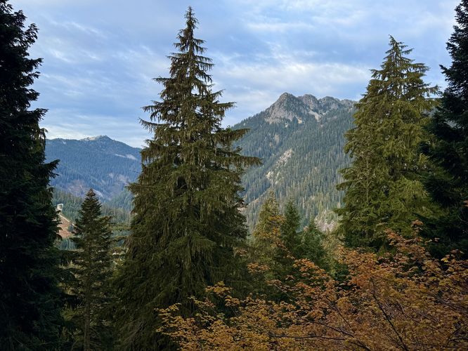
After hopping on the PCT, the trail heads into the forest following a moderate grade as it passes evergreens and old growth trees on the ascent toward the Alpine Lakes Wilderness boundary. The trail follows a few switchbacks with long stretches in between and offers seldom views before entering the wilderness. An obstructed view into Snoqualmie Pass can be found near mile 0.95 (1.46 km).
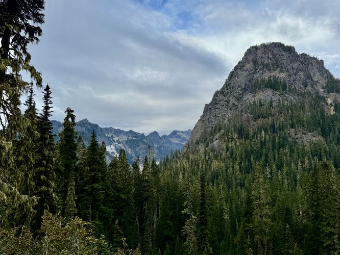
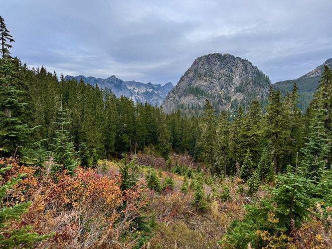
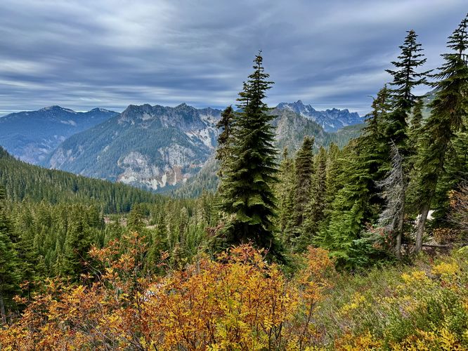
Views on the way toward Kendall Peak include the towering Guye Peak in Snoqualmie Pass and Red Mountain around mile 2, another view of Guye Peak and Snoqualmie Pass around mile 3.3, and a scenic south-facing view between the evergreens around mile 4.2.
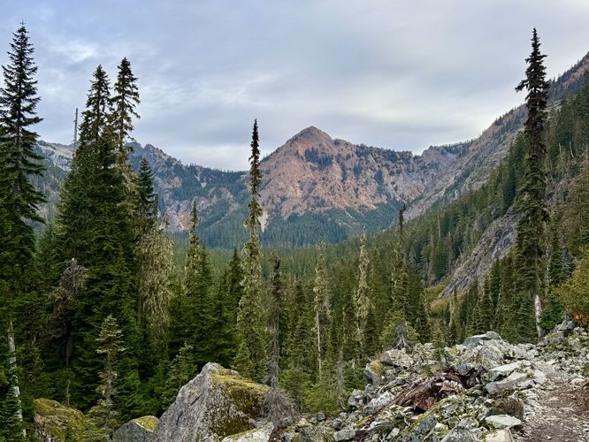
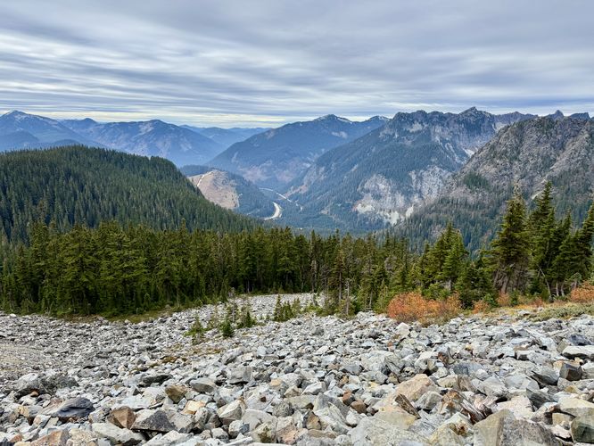
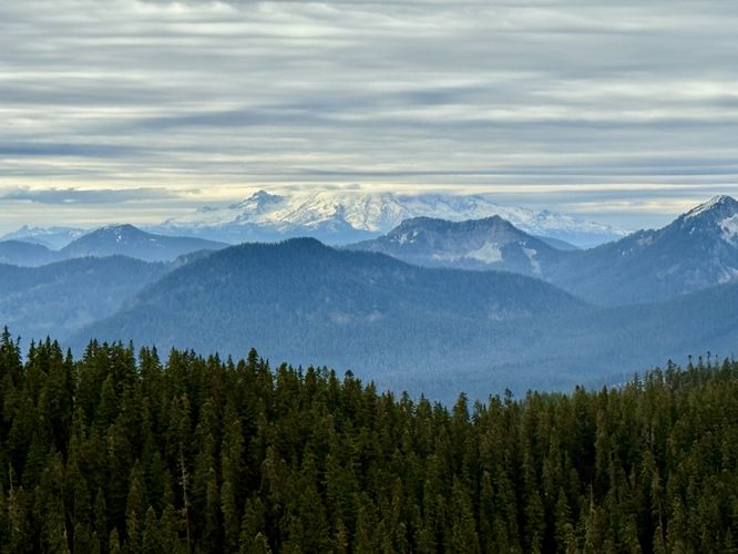
The PCT eventually enters a talus field on the western slopes of Kendall Peak near mile 4.65 where the hike leads you through an exposed subalpine zone with even more views. Here, between mile 4.65 and 5.5, hikers will find more stunning views of Washington's mountains including Mt. Rainier far in the distance. During our hike, Mt. Rainier's summit was enshrouded in clouds, but still made for a stunning view. Oh, and of course, there are more views into Snoqualmie Pass.
The Kendall Katwalk is not very long, only about 0.15-miles (~800-feet), but can be best appreciated from either end. The Katwalk was built in the early 1900s via dynamite to connect various trails in the area. Since then, it's been a sought-after destination for hikers in Washington, but far less popular than hiking destinations like Mt. Rainier National Park as we saw no one else along the Katwalk that day. As you hike across the Kendall Katwalk, be sure to stay clear of the steep slopes and stay on-trail to reach the other side safely.
For most hikers, once you reach the Kendall Katwalk, the hike is essentially over, but on this hike we decided to head out to Ridge Lake and Gravel Lake to wrap up our adventures in the Alpine Lakes Wilderness. The hike to reach both lakes is straight forward, just follow the PCT as it leads further into the wilderness. Along the way are more views toward Washington's Cascade Mountains in the distance and the Kendall Peak ridge as it slowly disappears as the trail dips downhill to reach the lakes.
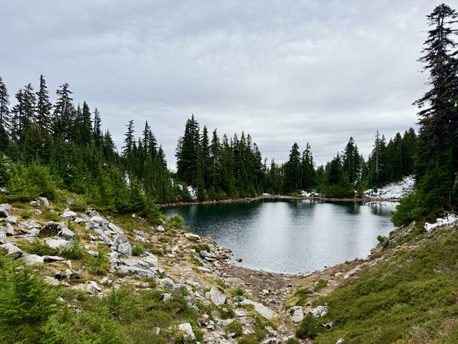
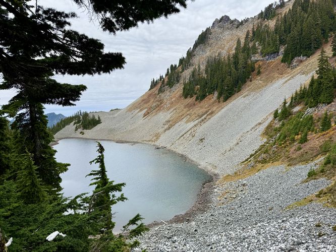
The first lake you'll reach is right on-trail, Ridge Lake. This small but scenic lake sits high in the subalpine zone with glassy water, surrounded by evergreen trees. Hike a bit further north and you'll find a half-decent view of the less-scenic Gravel Lake around mile 7.2. Gravel Lake sits below a rock-filled mountain slope, dotted with evergreen trees, and has grey-blue tint to the water. During hot summer days, both lakes are great spots to consider taking a dip to cool off.
Follow the long stretches of trail that sit between the handful of switchbacks, passing old growth trees, to reach the trailhead around mile 14.4 to wrap up the hike.
Mountain lions: While extremely rare to see, Washington state's mountainous regions are natural habitats for the cougar (mountain lion) and as such, it's best to not hike alone on this trail. For more information about Washington's cougar population, please see this PDF.
Weather: This hike leads into the subalpine zone and as such the weather can and does change fairly quickly. On this hike in mid-October, we started with a grey, cloudy day on the hike in. On the hike out, we were hit with rain and snow. Be prepared with the proper gear to stay dry and warm.
The Kendall Katwalk Hike is a difficult 14.4-mile out-and-back hike within the Mt. Baker-Snoqulamie National Forest that traverses the steep-sloped Kendall Katwalk, passes alpine meadows, talus slopes, old growth forests, features panoramic alpine views, and leads to two lakes — Ridge Lake and Gravel Lake.
Hiking to the Kendall Katwalk
This hike begins on the north side of I-90 in the heart of Snoqualmie Pass at the parking coordinates (47.427893, -121.413485) with the trailhead of the Pacific Crest Trail (#2000) located on the southeast side of the parking lot.After hopping on the PCT, the trail heads into the forest following a moderate grade as it passes evergreens and old growth trees on the ascent toward the Alpine Lakes Wilderness boundary. The trail follows a few switchbacks with long stretches in between and offers seldom views before entering the wilderness. An obstructed view into Snoqualmie Pass can be found near mile 0.95 (1.46 km).
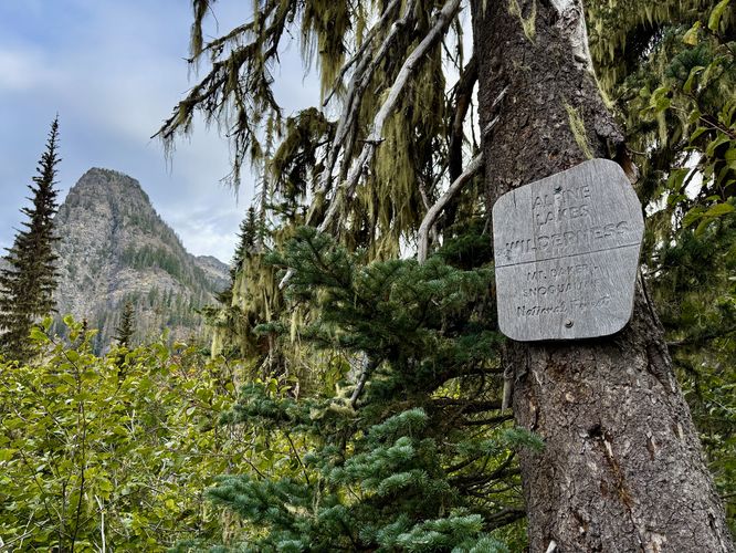
Enter the Alpine Lakes Wilderness - Mile 1.85
After passing three switchback curves, the PCT eventually reaches the boundary of the Alpine Lakes Wilderness around mile 1.85. Here, the hike up to the Kendall Katwalk becomes much more scenic with alpine vistas along the way as you make your way up toward Kendall Peak.Views on the way toward Kendall Peak include the towering Guye Peak in Snoqualmie Pass and Red Mountain around mile 2, another view of Guye Peak and Snoqualmie Pass around mile 3.3, and a scenic south-facing view between the evergreens around mile 4.2.
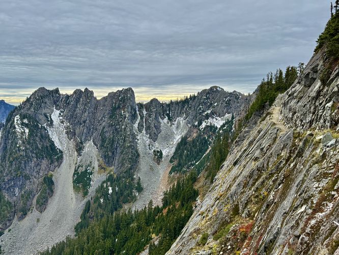
The PCT eventually enters a talus field on the western slopes of Kendall Peak near mile 4.65 where the hike leads you through an exposed subalpine zone with even more views. Here, between mile 4.65 and 5.5, hikers will find more stunning views of Washington's mountains including Mt. Rainier far in the distance. During our hike, Mt. Rainier's summit was enshrouded in clouds, but still made for a stunning view. Oh, and of course, there are more views into Snoqualmie Pass.
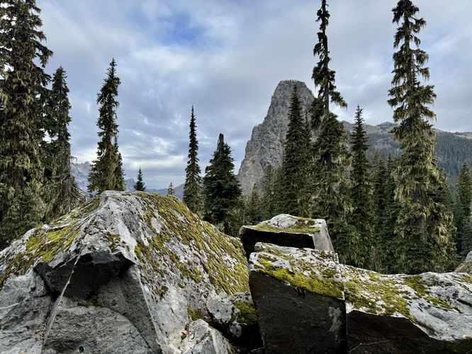
Kendall Katwalk - Mile 6 to 6.2
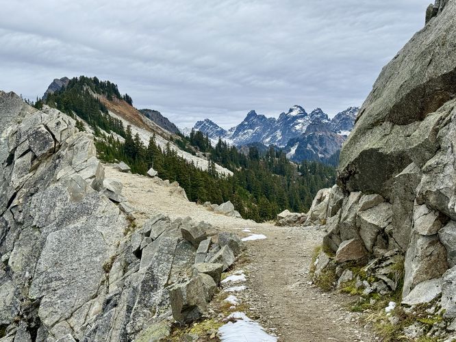
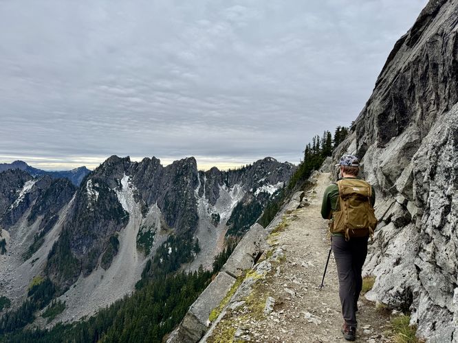
After passing the Kendall Peak Trail, the PCT continues to lead further into the subalpine along Kendall Ridge as it leads out to reach the famous Kendall Katwalk. Hikers will approach the south side of the Kendall Katwalk around mile 6. Here, you can go off-trail just a bit (watch your step!) to find panoramic views of the Cascade Mountains as the PCT continues along the mountain ridge.The Kendall Katwalk is not very long, only about 0.15-miles (~800-feet), but can be best appreciated from either end. The Katwalk was built in the early 1900s via dynamite to connect various trails in the area. Since then, it's been a sought-after destination for hikers in Washington, but far less popular than hiking destinations like Mt. Rainier National Park as we saw no one else along the Katwalk that day. As you hike across the Kendall Katwalk, be sure to stay clear of the steep slopes and stay on-trail to reach the other side safely.
Hiking to Ridge Lake & Gravel Lake - Mile 7.1 to 7.2
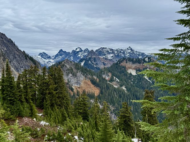
After traversing the Kendall Katwalk, you'll find some of the best views along the entire hike on the north side. Just turn around and face south where you'll find stunning views of the Katwalk, Kendall Peak, and the Kendall mountain ridge with its steep, dramatic slopes covered in loose rocks and dotted with evergreen trees.For most hikers, once you reach the Kendall Katwalk, the hike is essentially over, but on this hike we decided to head out to Ridge Lake and Gravel Lake to wrap up our adventures in the Alpine Lakes Wilderness. The hike to reach both lakes is straight forward, just follow the PCT as it leads further into the wilderness. Along the way are more views toward Washington's Cascade Mountains in the distance and the Kendall Peak ridge as it slowly disappears as the trail dips downhill to reach the lakes.
The first lake you'll reach is right on-trail, Ridge Lake. This small but scenic lake sits high in the subalpine zone with glassy water, surrounded by evergreen trees. Hike a bit further north and you'll find a half-decent view of the less-scenic Gravel Lake around mile 7.2. Gravel Lake sits below a rock-filled mountain slope, dotted with evergreen trees, and has grey-blue tint to the water. During hot summer days, both lakes are great spots to consider taking a dip to cool off.
Hiking Out - Mile 7.2 to 14.4
After exploring Ridge Lake and Gravel Lake, this hike heads back to the trailhead. To start the hike back, you'll first hike back uphill from the alpine lakes to reach the Kendall Katwalk once more. As previously stated, the views of the Katwalk are best from the northern end, so if you didn't get to enjoy the best views of the Kendall Katwalk on the hike in, now's your chance to enjoy them on the hike out. Traverse the Katwalk and follow the PCT back down the mountain from Kendall Peak, passing sweeping vistas of Snoqualmie Pass, Guye Peak, Red Mountain, and even Mt. Rainier on the way down.Follow the long stretches of trail that sit between the handful of switchbacks, passing old growth trees, to reach the trailhead around mile 14.4 to wrap up the hike.
Parking
Hikers will find a large parking lot at the coordinates provided (47.427893, -121.413485) -- located just off of the National Forest Development Road #9041 which connects to Denny Creek Road. The parking lot is large enough to fit a couple dozen vehicles as of October 2025.Difficulty Rating
This hike should be considered "Hard" for the average hiker due to the length of the trail and the consistent ascent required to reach the Kendall Katwalk; however, more experienced/avid hikers may find this hike to be on the moderate side.Warning
Steep terrain: This hike leads along sections of mountain ridge with steep terrain and sheer drop-offs. Be aware of your surroundings and it's best to stay on-trail.Mountain lions: While extremely rare to see, Washington state's mountainous regions are natural habitats for the cougar (mountain lion) and as such, it's best to not hike alone on this trail. For more information about Washington's cougar population, please see this PDF.
Weather: This hike leads into the subalpine zone and as such the weather can and does change fairly quickly. On this hike in mid-October, we started with a grey, cloudy day on the hike in. On the hike out, we were hit with rain and snow. Be prepared with the proper gear to stay dry and warm.