Kellogg Mountain Crags at State Game Lands 36 near Monroe, Pennsylvania is an easy 0.2-mile off-trail hike that leads to neat rock outcroppings that include rock overhangs, crags, and mini rock gorges.
Getting to SGL 36 (Seasonal Road)
Note that the road that leads up to Kellogg Mountain, within State Game Lands 36 (SGL 36) is closed outside of the hunting season. Hunting season, and thus gate openings and closures, change each year; however, during the 2023 - 2024 hunting season, the road's gates were opened mid-September and close January 21. The road will be re-opened in 2024 from April 25, 2024 to June 2, 2024. You can check the status of seasonal SGL roads here.
Hike Description
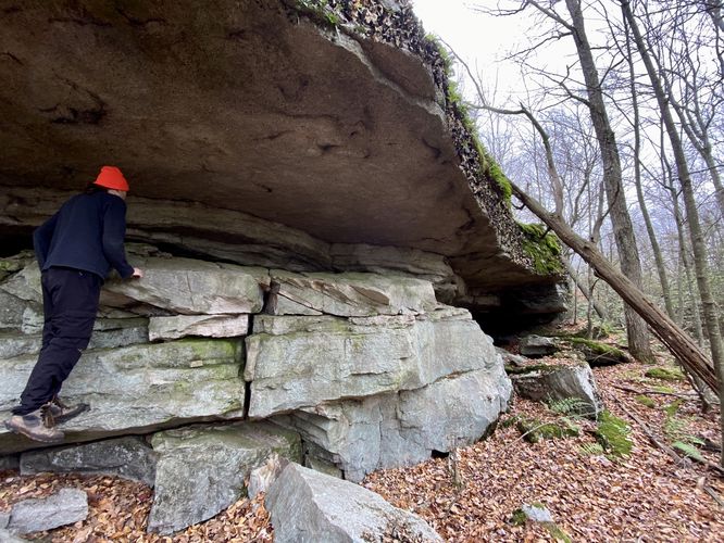
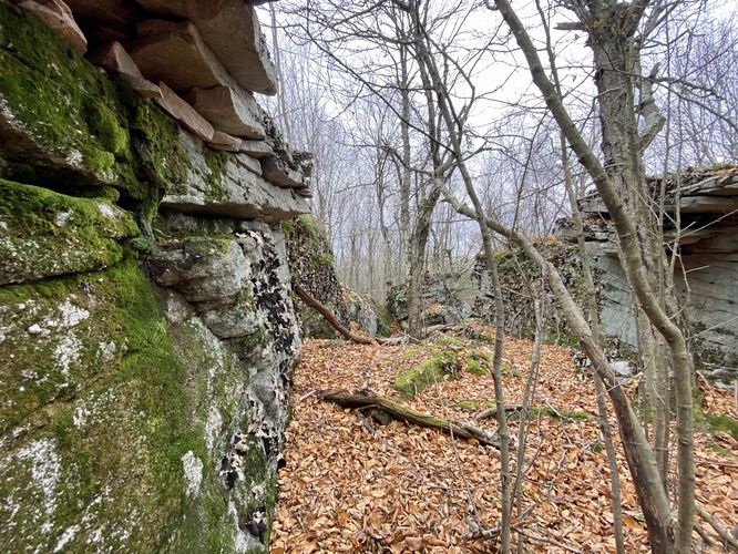
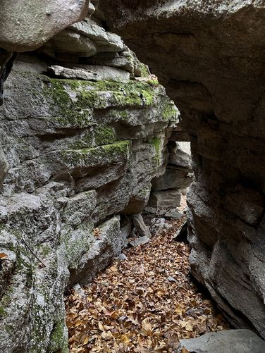
This hike begins near the trailhead and parking coordinates provided and heads into the woods off-trail, heading south from the road. The off-trail hike is pretty annoying at first as it leads through a very-rocky terrain where the rocks are covered by forest debris like leaves and such. Due to this, go extra slow to ensure proper footing and to prevent any injuries. Shortly after the annoying rock terrain, hikers will reach a ~15-foot tall rock ledge with a cave-like overhang underneath. The cave is no deeper than 5 or 6-feet, but runs a good length of the ledge at about 30-feet long. If you hike further south, you'll find a short rock crag or "gorge" that you can hike through. This track scrambles up the west side of the rock gorge to find yet another rock gorge / crag. You can hike down and into the crags, to pass through a fairly narrow section of the rocks where you'll find moss and lichen within this neat rock-scape scenery.
Once done exploring, you can hike out the same way you hiked in or you can attempt to head uphill slightly, as this track does, to ultimately head back downhill to reach the road. Be careful of the hidden rocks within the leaves on your way out.
Parking
Hikers will find parking at a turnout at the coordinates provided, located along the entrance road to the summit of Kellogg Mountain within SGL 36 -- only when the entrance road gates are opened. The road gates are opened between the months of mid-September to late January each year for hunting. Please check the Pennsylvania State Game Lands Commission for more details before heading out to ensure the road is open.
Warnings
Hunting: This hike leads through State Game Lands and due to the fact that this area is accessible during hunting season, it's smart to wear blaze orange while hiking here. During hunting season, it's against the law in Pennsylvania to hike through State Game Lands without blaze orange, so remember to bring it with you.
Hidden rocks: This off-trail hike leads through areas of large hidden rocks, covered by leaves. These can be super tricky to traverse over, never mind not hurting yourself in the process. Be extra careful when hiking out to the rock outcroppings.
Timber Rattlesnakes: This trail leads through exposed bedrock mountain terrain that's perfect for Timber Rattlesnake basking and sun bathing. While a bit more rare in this part of the state, be on the lookout for rattlers and give any you find plenty of space.
Getting to SGL 36 (Seasonal Road)
Note that the road that leads up to Kellogg Mountain, within State Game Lands 36 (SGL 36) is closed outside of the hunting season. Hunting season, and thus gate openings and closures, change each year; however, during the 2023 - 2024 hunting season, the road's gates were opened mid-September and close January 21. The road will be re-opened in 2024 from April 25, 2024 to June 2, 2024. You can check the status of seasonal SGL roads here.
Hike Description
This hike begins near the trailhead and parking coordinates provided and heads into the woods off-trail, heading south from the road. The off-trail hike is pretty annoying at first as it leads through a very-rocky terrain where the rocks are covered by forest debris like leaves and such. Due to this, go extra slow to ensure proper footing and to prevent any injuries. Shortly after the annoying rock terrain, hikers will reach a ~15-foot tall rock ledge with a cave-like overhang underneath. The cave is no deeper than 5 or 6-feet, but runs a good length of the ledge at about 30-feet long. If you hike further south, you'll find a short rock crag or "gorge" that you can hike through. This track scrambles up the west side of the rock gorge to find yet another rock gorge / crag. You can hike down and into the crags, to pass through a fairly narrow section of the rocks where you'll find moss and lichen within this neat rock-scape scenery.
Once done exploring, you can hike out the same way you hiked in or you can attempt to head uphill slightly, as this track does, to ultimately head back downhill to reach the road. Be careful of the hidden rocks within the leaves on your way out.
Parking
Hikers will find parking at a turnout at the coordinates provided, located along the entrance road to the summit of Kellogg Mountain within SGL 36 -- only when the entrance road gates are opened. The road gates are opened between the months of mid-September to late January each year for hunting. Please check the Pennsylvania State Game Lands Commission for more details before heading out to ensure the road is open.
Warnings
Hunting: This hike leads through State Game Lands and due to the fact that this area is accessible during hunting season, it's smart to wear blaze orange while hiking here. During hunting season, it's against the law in Pennsylvania to hike through State Game Lands without blaze orange, so remember to bring it with you.
Hidden rocks: This off-trail hike leads through areas of large hidden rocks, covered by leaves. These can be super tricky to traverse over, never mind not hurting yourself in the process. Be extra careful when hiking out to the rock outcroppings.
Timber Rattlesnakes: This trail leads through exposed bedrock mountain terrain that's perfect for Timber Rattlesnake basking and sun bathing. While a bit more rare in this part of the state, be on the lookout for rattlers and give any you find plenty of space.