Loading...

๐ŸŽ‰ Enjoy a Free 7-Day Supporter Trial and Unlock Exclusive Perks โ€” No Credit Card Required. Learn more.

Kealia Coastal Boardwalk

Directions
Map
Pictures
Send to App
Distance:
0.8 Miles / 1.3 km
Type:
Out-and-Back
Difficulty:
Easy
Time to Hike:
~24 minutes
Features:
Surface Type:
Boardwalk
Park:
Kealia Pond National Wildlife Refuge
Town:
Kihei, Hawaii
Directions:
20.795956, -156.485693
Added:
August 16, 2018
Updated:
January 23, 2020
Copy Trail Link Hiking this trail? Send a friend or family member a link to this trail guide for your own safety. Hike at your own risk (disclaimer)
Loading...
Loading...
18'

Total Change
59'

Ascent
59'

Descent

Download the Trail Route for Offline Use

Supporters get exclusive access to download trail routes to the MyHikes app for offline use. Stay prepared on your adventure, even without an internet connection! Become a Supporter today to unlock this feature and hike with confidence.

Send to App

Kealia Coastal Boardwalk

The Kealia Coastal Boardwalk Trail at Kealia Pond National Wildlife Refuge in Kihei, Maui is an easy 0.8 mile out-and-back walk that runs between the ocean and Kealia Pond.

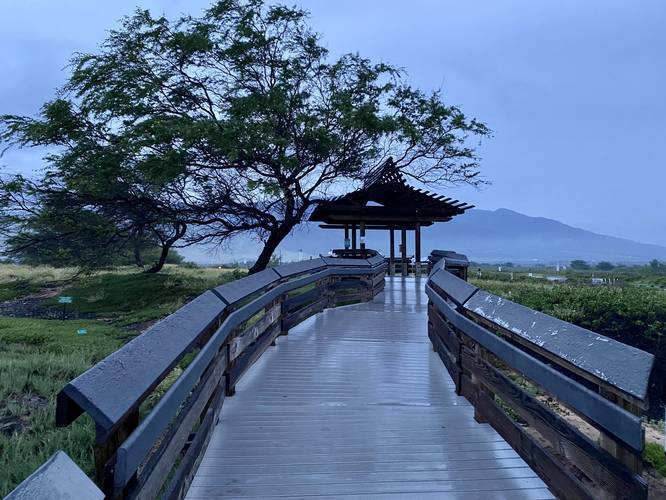
The trail leads out to a couple different hut-like viewing areas where you get views of the mountains surrounding central Maui (west Maui mountains and the Haleakala range to the east), the beach, Kealia Pond, and the island of Lanai off the coast.

There are also several small spur trails that leads out to the beach, which is usually not crowded.

Dogs are not allowed on this trail.

Respecting the Land
Hawaiian land is considered sacred to native Hawaiians and many locals, so please stay on-trail, take nothing but photos, and leave nothing but footprints. Respect the locals - don't stay for long and have a backup hike planned in case the parking lot is full.
Explore 57 trails near Kihei, HI
  1. Parking

    20.795956, -156.485693
  2. Main Trailhead

    20.795458, -156.485334
No community routes found. To add your own hike as a Community Route for this Trail guide, leave a Trip Report with an attached GPX file.

Seasons

All

Trip Reports

Trail Guide By:
Admin user profile picture
0.8 miles / 1.3 km
0.8 miles / 1.3 km
February 17, 2023
Hiking
0.8 miles / 1.3 km
February 17, 2023
Rainy sunrise walk along the Kealia Pond Boardwalk. Lots of migratory birds hunting for their breakfast in the shallow swamp waters. Nice views of the West Maui Mountains as the sun came up. Love this trail.
Hiking
0.8 miles / 1.3 km
August 15, 2018
Hiking
Preview of the MyHikes mobile app interface

Track, Log, and Explore Hikes with the MyHikes App

Shop Landscape Prints
Shop our landscape prints from Maui, Hawaii

Weather Forecast

In Kihei, HI

Explore Hiking Trails

You May Also Like

Colorado's Million Dollar Highway - Plan a day's drive adventure along the iconic Million Dollar Highway in Colorado. Explore the best short trails, roadside stops, waterfalls, vistas, ghost towns, and hot springs within a ~6 hour road trip.
Explore

Colorado's Million Dollar Highway

Plan a day's drive adventure along the iconic Million Dollar Highway in Colorado. Explore the best short trails, roadside stops, waterfalls, vistas, ghost towns, and hot springs within a ~6 hour road trip.

Read
Glacier's Going-to-the-Sun Road - Discover the breathtaking beauty of Glacier National Park along the iconic Going-to-the-Sun Road. From stunning roadside stops to picturesque waterfalls and vistas, this engineering marvel offers endless opportunities for exploration.
Explore

Glacier's Going-to-the-Sun Road

Discover the breathtaking beauty of Glacier National Park along the iconic Going-to-the-Sun Road. From stunning roadside stops to picturesque waterfalls and vistas, this engineering marvel offers endless opportunities for exploration.

Read
New York's Best Waterfalls - Whether you're planning a day hike, roadside stop, or a leisurely short walk, this guide provides hikers, travelers, and locals alike with 63 different locations to over 100 scenic waterfalls to help plan your next adventure!
Explore

New York's Best Waterfalls

Whether you're planning a day hike, roadside stop, or a leisurely short walk, this guide provides hikers, travelers, and locals alike with 63 different locations to over 100 scenic waterfalls to help plan your next adventure!

Read

Before you boogie...

Find our trail guides useful? Consider becoming a Supporter to unlock perks!

MyHikes is an indie platform that makes exploring public trails easier for everyone. The platform has no investors, no ads, and is owned and operated by one person, Dave Miller. Dave has personally mapped and written over 1,800 trail guides on MyHikes for the public to explore. MyHikes has helped millions outdoor enthusiasts plan their next adventure.

But it takes a lot of time ๐Ÿ•ฆ, money ๐Ÿ’ฐ, work, and espresso shots โ˜• to run MyHikes, including hiking , mapping , writing , and publishing new trails with high-quality (accurate) information... along with software engineering (coding) the platform like building new features, website and mobile app development (iOS and Android), site maintainance . and much much more.

Supporters unlock website and mobile app perks with an annual one-time payment of $25 (you renew) ๐Ÿ˜Ž๐Ÿ‘. Or you can simply make a Donation of your choice. Otherwise, you can support us by telling your friends about MyHikes - both quick and free ๐ŸŽ‰

Admin user profile picture

Dave Miller
MyHikes Founder