Loading...

WINTER SALE! 50% OFF Supporter Accounts — now through January 31st. Learn More.

Kautz Creek Nature Trail

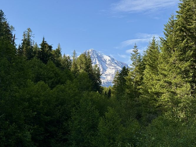
The Kautz Creek Nature Trail at Mt. Rainier National Park near Longmire, Washington is an easy 0.1-mile out-and-back trail that leads to a view of Mt. Rainier from the southern end of the Kautz Creek Valley.

Explore Kautz Creek Valley

This short boardwalk trail leads from the main parking area, located on the south side of Paradise Valley Road, westward to the edge of Kautz Creek. Along the boardwalk are information signs that help visitors better understand the natural topography and dangers of being downstream from Mt. Rainier's glaciers and glacial melt.

In short, Kautz Creek valley really could be flooded at any time by glacial melt or a catastrophic landslide on Mt. Rainier. While the vegetation thats growing along Kautz Creek almost takes over most of the view you'll find near the end of the trail, this doesn't mean that flash floods do not occur here. Following the boardwalk to the edge of Kautz Creek, you'll be standing next to the Paradise Valley Road bridge that spans the water with a forest of younger-growth trees that fill in the banks. To the north, however, is a view of Mt. Rainier's glacier-covered peak as it reaches over the trees. Note that over time these trees may completely fill-in the view, leaving visitors with a short walk to the water's edge of Kautz Creek instead.

While yes, there are better views of Mt. Rainier at Mt. Rainier National Park this very short out-and-back, universally-accessible trail provides a quick and easy way to appreciate the mountain from a different perspective.

Universal Access

This trail is universally accessible from the parking lot out to where the boardwalk ends where you'll find a view of Mt. Rainier. Note that the trail surface between the boardwalk and the exposed dirt area may not be accessible for every situation or visitor, but the terrain is flat with no roots to trip on.

Parking & Fees

Visitors will find a large parking lot on the south side of Paradise Valley Road on your way into the Longmire / Paradise areas of Mt. Rainier National Park. The lot is large enough to fit several dozen vehicles as of June 2025. As of June 2025, there's a $25 entry fee for the park which is good for several days. If you plan ahead, you can speed up your entry with an Annual National Park's Pass.

Pets

All pets, including dogs, are not allowed on any trails within Mt. Rainier National Park, so please leave your dogs at home.

Warning

Flash flooding: During certain times of the year, especially in spring with snow and glacier melt, in addition to heavy rainfall, there may be flash flooding along Kautz Creek. Flash floods happen in an instant, so be aware of the dangers while out exploring.
Explore 11 trails near Longmire, WA

Know Before You Go

  • The Kautz Creek Nature Trail is a short, accessible boardwalk offering views of Mt. Rainier and information about glacial melt dangers.
  • Kautz Creek Valley is susceptible to flash floods from glacial melt or landslides, requiring caution when visiting.
  • The trail is located near Longmire, WA, within Mt. Rainier National Park, requiring an entry fee and prohibiting pets.
Interactive topographic map for Kautz Creek Nature Trail located in Longmire, WA. Click the "View Map" button to load GPS coordinates and trail markers.
Get directions
Distance
0.1 mi
Difficulty
Easy
Type
Out-and-Back
Est. Time
5 min
Elev. Gain
8'
Rating
0.0
Added
June 16, 2025
Updated
July 02, 2025

Weather Forecast

Loading...
Total Change
8'
Ascent
8'
Descent
8'
Loading...

Download the GPX Data for Offline Use

Supporters get exclusive access to download trail routes to the MyHikes app for offline use. Stay prepared on your adventure, even without an internet connection! Become a Supporter today to unlock this feature and hike with confidence.

Download Kautz Creek Nature Trail GPX Data to the MyHikes Mobile App

Features

Vista / Lookout Point

Points of interest

  1. Parking

    46.736005, -121.855948
  2. Main Trailhead

    46.736156, -121.855749

Safety information

For your own safety: plan ahead, let someone know where you'll be, and hike at your own risk.

Availability

All seasons

Surface type

Universal Access

Trip Reports (Reviews)

Your opinion matters! Be the first to rate this trail.

Ready to help fellow hikers? Add a trip report to share your experience and provide valuable insights for other hikers!

0.1 miles / 0.2 km
June 16, 2025
Hiking
No community routes found. To add your own hike as a Community Route for this Trail guide, leave a Trip Report with an attached GPX file.

Popular categories

Scenic mountain view representing vista trails
Vista trails
Scenic gorge of cascades representing waterfall trails
Waterfall hikes
Rugged mountain terrain representing summit trails
Summit trails
Scenic mountain view representing dog-friendly trails
Dog-friendly
Scenic campsite with a view representing camping trails
Camping trails
Appalachian Trail logo representing A.T. hikes
A.T. hikes

You May Also Like

Glacier's Going-to-the-Sun Road - Discover the breathtaking beauty of Glacier National Park along the iconic Going-to-the-Sun Road. From stunning roadside stops to picturesque waterfalls and vistas, this engineering marvel offers endless opportunities for exploration.
Explore

Glacier's Going-to-the-Sun Road

Discover the breathtaking beauty of Glacier National Park along the iconic Going-to-the-Sun Road. From stunning roadside stops to picturesque waterfalls and vistas, this engineering marvel offers endless opportunities for exploration.

Read
Colorado's Million Dollar Highway - Plan a day's drive adventure along the iconic Million Dollar Highway in Colorado. Explore the best short trails, roadside stops, waterfalls, vistas, ghost towns, and hot springs within a ~6 hour road trip.
Explore

Colorado's Million Dollar Highway

Plan a day's drive adventure along the iconic Million Dollar Highway in Colorado. Explore the best short trails, roadside stops, waterfalls, vistas, ghost towns, and hot springs within a ~6 hour road trip.

Read
🍪 We use cookies to learn about site usage and to serve map tiles. You may block cookies manually in the browser. By continuing you agree. Learn more