The Kahakuloa Head Trail in Kahakuloa, Hawaii (Maui) is an easy 0.1-mile out-and-back walk that leads to the mountains (cinder cones) that make up Kahakuloa Head - Pu'u Koa'e and Pu'ukahuli'anapa.
Hike Description
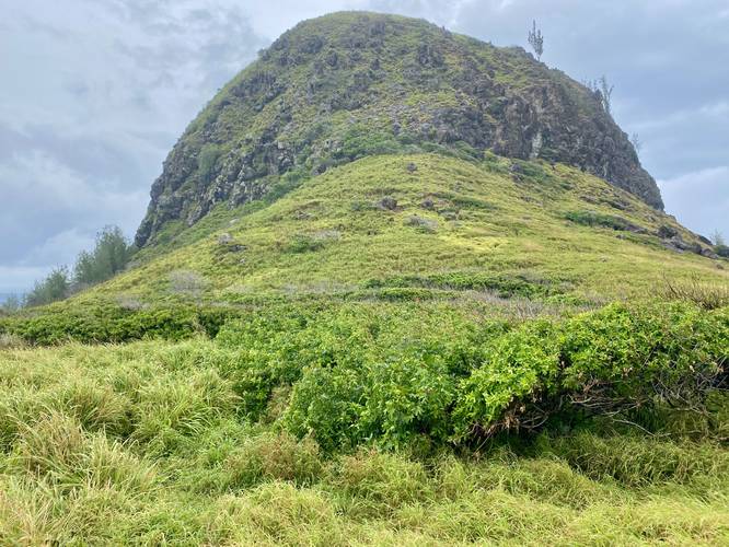
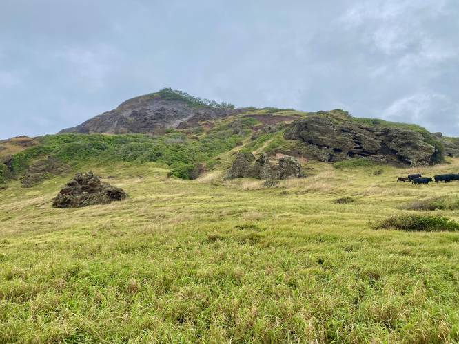
This is less of a hike and more of a quick farmland walk; however, for the curious tourist hiker, this is an interesting spot to take a walk due to being able to hike directly between the seaside mountains (cinder cones) that make up Kahakuloa Head. The trailhead is located in the middle of a large parking turnout and is technically a cow gate in the barbed-wire fence. This land is owned by the State of Hawaii but leased out to local ranchers for their cattle and goats to graze. With that said, upon entering this trail, you might encounter a curious group of cattle or might hear goats alerting their friends to your presence while sitting perched on the slopes of Pu'u Koa'e (north) or Pu'ukahuli'anapa (south).
The trail that leads between Pu'u Koa'e and Pu'ukahuli'anapa is a skinny overgrown grass path that has one somewhat-steep section to it that leads down into the grasslands. Upon my hike here, the cows weren't used to tourists coming through, and hence, were slowly walking toward me to get a better look. It wasn't long before a pack of additional tourists saw my vehicle and decided to give this spot a look too - thus scaring the entire pack of cows into a corner. Regardless of my experience, the trail leads down toward a dangerous section of seaside cliffs that makeup these old cinder cones. I stayed back from where the land begins to transform from grasslands to sandy slides of short cliffs, which eventually lead to large ones.
From between Pu'u Koa'e and Pu'ukahuli'anapa, hikers get interesting views from just below these giant cinder cones / seaside mountains.
Parking
Hikers will find larger parking lot at the coordinates provided, which is large enough to fit about 10 cars or so.
Pets
Dogs should not be brought here due to local rancher's lease rights.
Local Ranching Lease Rights & Respect the Animals
Please respect the local ranchers who lease this land and stay on-trail and simply enjoy the scenery for a short time without disturbing their animals. Calling out to farm animals, in packs, is not a great idea as you cannot control their movement, where they go, or how scared they can become.
Warning
Cliffs: Further down this trail are steep cliffs. It's best to stay back on the grasslands for this walk.
Respecting the Land
Hawaiian land is considered sacred to native Hawaiians and many locals, so please stay on-trail, take nothing but photos, and leave nothing but footprints. Respect the locals - don't stay for long and have a backup hike planned in case the parking lot is full.
Hike Description
This is less of a hike and more of a quick farmland walk; however, for the curious tourist hiker, this is an interesting spot to take a walk due to being able to hike directly between the seaside mountains (cinder cones) that make up Kahakuloa Head. The trailhead is located in the middle of a large parking turnout and is technically a cow gate in the barbed-wire fence. This land is owned by the State of Hawaii but leased out to local ranchers for their cattle and goats to graze. With that said, upon entering this trail, you might encounter a curious group of cattle or might hear goats alerting their friends to your presence while sitting perched on the slopes of Pu'u Koa'e (north) or Pu'ukahuli'anapa (south).
The trail that leads between Pu'u Koa'e and Pu'ukahuli'anapa is a skinny overgrown grass path that has one somewhat-steep section to it that leads down into the grasslands. Upon my hike here, the cows weren't used to tourists coming through, and hence, were slowly walking toward me to get a better look. It wasn't long before a pack of additional tourists saw my vehicle and decided to give this spot a look too - thus scaring the entire pack of cows into a corner. Regardless of my experience, the trail leads down toward a dangerous section of seaside cliffs that makeup these old cinder cones. I stayed back from where the land begins to transform from grasslands to sandy slides of short cliffs, which eventually lead to large ones.
From between Pu'u Koa'e and Pu'ukahuli'anapa, hikers get interesting views from just below these giant cinder cones / seaside mountains.
Parking
Hikers will find larger parking lot at the coordinates provided, which is large enough to fit about 10 cars or so.
Pets
Dogs should not be brought here due to local rancher's lease rights.
Local Ranching Lease Rights & Respect the Animals
Please respect the local ranchers who lease this land and stay on-trail and simply enjoy the scenery for a short time without disturbing their animals. Calling out to farm animals, in packs, is not a great idea as you cannot control their movement, where they go, or how scared they can become.
Warning
Cliffs: Further down this trail are steep cliffs. It's best to stay back on the grasslands for this walk.
Respecting the Land
Hawaiian land is considered sacred to native Hawaiians and many locals, so please stay on-trail, take nothing but photos, and leave nothing but footprints. Respect the locals - don't stay for long and have a backup hike planned in case the parking lot is full.