The Ka'anapali Beach Path in Kaanapali, Hawaii (Maui) is an easy 3.1-mile out-and-back trail that features views of the islands of Lanai and Molokai, provides beach access, and includes a historical abandoned pier.
Walk Description
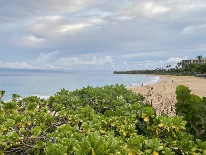
This is not a hike, but rather a trail that runs the length of Kahekili Beach following boardwalk and paved substrates. The northern trailhead starts at Honoapiilani Park and follows the boardwalk path as it heads south, passing a multitude of resorts and beach access points along the way.
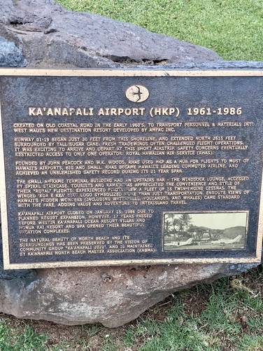
Historical Airport Marker - Mile 0.67
Around mile 0.67, walkers will pass a historical marker and plaque dedicated to an old, long abandoned, and destroyed airport that was used from 1961 - 1986. During the early 1960s this airport was used to transport personel and materials into West Maui's "new" destination resort developed by AMFAC Inc. The airport closed in 1968 due to planned resort expansion, which took approximately 17-years to complete.
Parking Lots, Condos, and Sidewalks - Mile 0.9 to 1.3
At mile 0.9, walkers will reach a parking lot - take a right-hand turn here to continue following the designated trail. It then passes through resort condos before following Kekaa Drive for a short while - passing several storefronts. The trail take a turn and heads back through resort condos around mile 1.1 to 1.3.
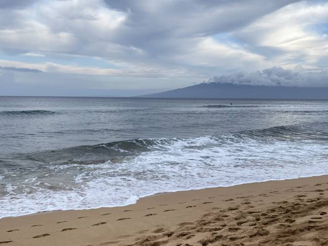
Southern Beach Access - Mile 1.4
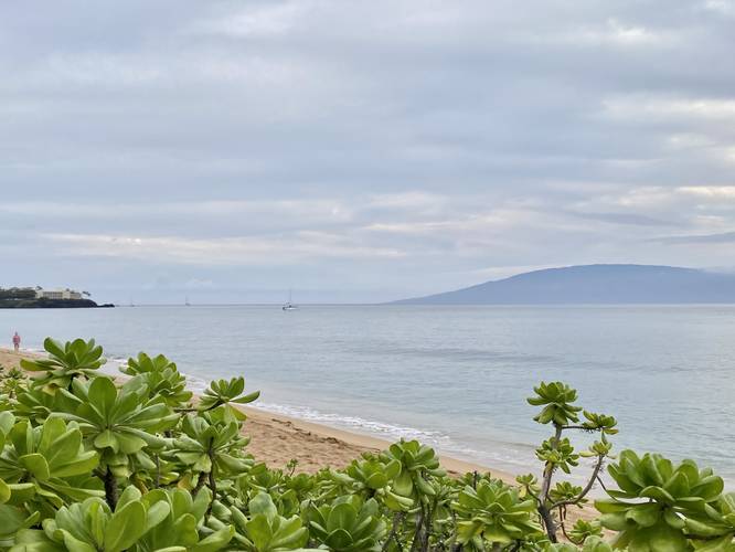
At mile 1.4, walks will reach the southern-most point for beach access. During the Winter this is a nice spot to take a break, enjoy some coffee, and watch the whales.
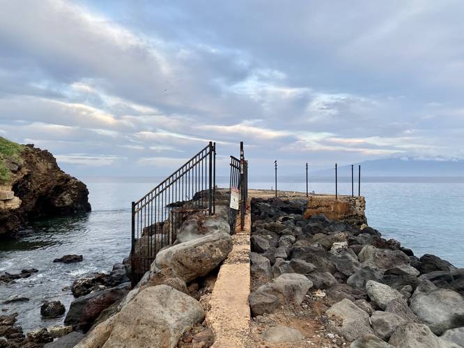
Historical Kea'a Landing Pier - Mile 1.5
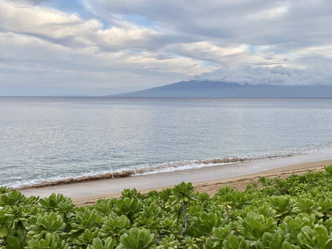
If interested in some additional history, the Kea'a Landing Pier sits around mile 1.5. This abandoned and very decapitated jetty used to jut far out into the ocean. The Kea'a Landing Pier was used to ship processed sugar from the island and bring in supplies for the plantation camps. Railroad tracks led from the sugar plantations to the beach, and warehouses for storage were located nearby. All that remains is an asphalt jetty. Despite the historical significance, the Kea'a Landing Pier is a nice spot to take pictures of the beach and the island of Molokai in the distance - or to watch for whales during the Winter.
Shortly after passing the Kea'a Landing Pier, the trail ends along Ka'anapali Parkway. On the walk out, don't forget to stop at beach access points for views, as there are not many views from the trail itself except for near the pier at the south.
Connecting to Ka'anapali Beachwalk
Walkers can connect this northern trail to another trail that runs along Ka'anapali Beach, located to the south, called the Ka'anapali Beachwalk if you walk through the resort areas located between both routes.
Whale Watching
During the Winter, this is a nice walk for whale watching.
Parking
Walkers will find a very large parking lot at the coordinates provided. The lot is large enough to fit several dozen vehicles.
Restrooms
Public restrooms can be found at the parking lot (coordinates provided).
Trail Surface / Accessibility
This trail follows a boardwalk path until Mile 0.9 (headed south), where it meets a parking lot and switches to pavement and then concrete. This trail may not be fully universally accessible, but is close to it.
Warning
Stay off jetty/pier: It's best to obey the law and stay off the abandoned pier / jetty from where the metal fence begins to ensure your own safety.
Respecting the Land
Hawaiian land is considered sacred to native Hawaiians and many locals, so please stay on-trail, take nothing but photos, and leave nothing but footprints. Respect the locals - don't stay for long and have a backup hike planned in case the parking lot is full.
Walk Description
This is not a hike, but rather a trail that runs the length of Kahekili Beach following boardwalk and paved substrates. The northern trailhead starts at Honoapiilani Park and follows the boardwalk path as it heads south, passing a multitude of resorts and beach access points along the way.
Historical Airport Marker - Mile 0.67
Around mile 0.67, walkers will pass a historical marker and plaque dedicated to an old, long abandoned, and destroyed airport that was used from 1961 - 1986. During the early 1960s this airport was used to transport personel and materials into West Maui's "new" destination resort developed by AMFAC Inc. The airport closed in 1968 due to planned resort expansion, which took approximately 17-years to complete.
Parking Lots, Condos, and Sidewalks - Mile 0.9 to 1.3
At mile 0.9, walkers will reach a parking lot - take a right-hand turn here to continue following the designated trail. It then passes through resort condos before following Kekaa Drive for a short while - passing several storefronts. The trail take a turn and heads back through resort condos around mile 1.1 to 1.3.
Southern Beach Access - Mile 1.4
At mile 1.4, walks will reach the southern-most point for beach access. During the Winter this is a nice spot to take a break, enjoy some coffee, and watch the whales.
Historical Kea'a Landing Pier - Mile 1.5
If interested in some additional history, the Kea'a Landing Pier sits around mile 1.5. This abandoned and very decapitated jetty used to jut far out into the ocean. The Kea'a Landing Pier was used to ship processed sugar from the island and bring in supplies for the plantation camps. Railroad tracks led from the sugar plantations to the beach, and warehouses for storage were located nearby. All that remains is an asphalt jetty. Despite the historical significance, the Kea'a Landing Pier is a nice spot to take pictures of the beach and the island of Molokai in the distance - or to watch for whales during the Winter.
Shortly after passing the Kea'a Landing Pier, the trail ends along Ka'anapali Parkway. On the walk out, don't forget to stop at beach access points for views, as there are not many views from the trail itself except for near the pier at the south.
Connecting to Ka'anapali Beachwalk
Walkers can connect this northern trail to another trail that runs along Ka'anapali Beach, located to the south, called the Ka'anapali Beachwalk if you walk through the resort areas located between both routes.
Whale Watching
During the Winter, this is a nice walk for whale watching.
Parking
Walkers will find a very large parking lot at the coordinates provided. The lot is large enough to fit several dozen vehicles.
Restrooms
Public restrooms can be found at the parking lot (coordinates provided).
Trail Surface / Accessibility
This trail follows a boardwalk path until Mile 0.9 (headed south), where it meets a parking lot and switches to pavement and then concrete. This trail may not be fully universally accessible, but is close to it.
Warning
Stay off jetty/pier: It's best to obey the law and stay off the abandoned pier / jetty from where the metal fence begins to ensure your own safety.
Respecting the Land
Hawaiian land is considered sacred to native Hawaiians and many locals, so please stay on-trail, take nothing but photos, and leave nothing but footprints. Respect the locals - don't stay for long and have a backup hike planned in case the parking lot is full.