This strenuous hike is best visited in the late spring/early summer when the numerous thickets of mountain laurel and wild azalea are in full bloom. Wildflowers such as pink lady’s slippers are present along much of the trail during the spring and summer. The hike features sweeping views from Bear Church Rock as well as over 1,000 acres of old growth forest in the Staunton River Valley. A PATC-restored cabin from the 1850s and traces of logging performed during the Park’s construction offer the chance to see some of the SNP’s early history.
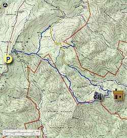
- Mile 0.0 – From the Bootens Gap parking lot turn left onto the AT and head north. In 0.4 miles turn right onto Laurel Prong Trail as it branches off from the AT.
- Mile 1.4 – Laurel Prong Trail gradually descends along the shoulder of the ridge until it reaches an intersection with Cat Knob Trail. Continue straight on Cat Knob Trail.
- Mile 1.9 – Cat Knob Trail climbs almost 500 feet in half a mile to the summit of Cat Knob, where it intersects with Fork Mountain Trail from the left. Continue straight on Cat Knob Trail.
- Mile 4.2 – After cresting the summit of Cat Knob the trail begins to descend along the ridge of Jones Mountain as it skirts the edge of Rapidan Wildlife Management Area to the south. Around Mile 2.5 the trail becomes Jones Mountain Trail as the pink-blazed RWMA Cat Knob Access Trail merges from the right. The trail passes through several large stands of mountain laurel and wild azaleas with patches of ferns and wildflowers growing along the route.
- Mile 4.9 – The trail winds through several boulder formations a half-mile before reaching Bear Church Rock just off the left of the main trail. The panoramic view looks out across the Staunton River towards Fork Mountain to the north and Doubletop Mountain to the northeast.
- Mile 5.3 – Continue descending down the mountain, passing a ~0.3 mile cutoff trail to the PATC’s Jones Mountain Cabin on the right. Originally built by Albert Nichols in 1855, the cabin has been restored by the Potomac Appalachian Trail Club and is now available for public rental by campers.
- Mile 5.5 – Keep left onto McDaniel Hollow Trail.
- Mile 5.9 – In less than half a mile the McDaniel Hollow Trail ends near a stream crossing. Turn left onto Staunton River Trail and follow it up the valley, passing by several small waterfalls and stream crossings. At one stream crossing you will come across an old slab pile made up of scraps left over from sawing logs into planks. Dead standing chestnuts were removed from the Staunton River Valley in 1938 and used to construct the main lodge and cabins at Big Meadows; it is possible this slab pile is a remnant of this logging activity.
- Mile 7.2 – The Staunton River Trail ends at the Fork Mountain Fire Road. Turn left onto the gravel fire road and continue hiking upwards.
- Mile 7.9 – The fire road reaches ‘The Sag’, a saddle between Cat Knob to the southwest and Fork Mountain to the northeast. The fire road intersects with Fork Mountain trail here before continuing an extra ~0.7 miles to an FAA repeater station on the top of Fork Mountain. Turn off the fire road onto Fork Mountain Trail and take the right-hand branch that descends towards Rapidan Camp. Note – the left-hand branch of Fork Mountain Trail returns to the Cat Knob Trail and can be used to cut ~1.1 miles and a few hundred feet elevation gain off the hike.
- Mile 9.1 – The Fork Mountain trail switchbacks several times as it descends into the valley. Cross the Laurel Prong stream before the trail ends at Laurel Prong Trail. Turn left onto Laurel Prong Trail and follow it south up the valley.
- Mile 10.4 – As the trail climbs it passes through ‘The Laurels’, a section of mountain laurels that surround the trail. Eventually reach the intersection with Cat Knob Trail that you passed at Mile 1.4. Turn right on Laurel Prong Trail to head back to the parking lot.
- Mile 13.9 – Keep left onto the AT a half mile before returning to the Bootens Gap parking lot.