Johnson Hill Falls at Hemlock-Canadice State Forest in Springwater, New York is a moderate 1.1-mile out-and-back hike that leads to the 50-foot tall waterfall, Johnson Hill Falls.
Hike Description
This hike begins along Johnson Hill Road in a small parking lot at the coordinates provided and follows the Johnson Hill Trail as it heads due-south. Note that the Johnson Hill Trail is foot traffic only. During the Spring, hikers may find wildflowers like violets and geranium along the trail. The trail itself is easy to follow, but passes through some muddy section which can be a bit buggy depends on how saturated the ground is.
Johnson Hill Falls - Mile 0.45
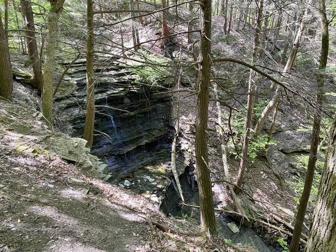
Around mile 0.45, hikers will reach a bend in the trail as it curves around to reach a view of Johnson Hill Falls from the side of the gorge. Johnson Hill Falls cascades down approximately 45 to 50-feet into the gorge below. Hikers can follow the trail as it leads downhill and toward State Highway 15A, getting different views of the waterfall on your way down the hill; however, most of the views are obstructed. Also note that during mid-May 2023, the water level was very low and thus the waterfall was merely a trickle. Downstream, and out of sight, lies another waterfall that cascades down what sounded like a free-fall cliff too; however, there was no view of that lower waterfall.
Hike to Highway 15A
If you wish you can follow the trail all the way down the hill from Johnson Hill Falls to the highway for a 1.1 mile out-and-back hike; however, this is only for exercise as the trail doesn't have anything else to see.
Hiking out is simple - hike the same way you came in. Watch for muddy spots.
Difficulty
If skipping the hillside hike down and back up, this should be considered an easy hike instead of moderate.
Parking
Hikers will find a small parking lot at the coordinates provided. It's large enough to fit less than a dozen vehicles.
Pets
Dogs are allowed only if leashed and must be cleaned up after.
Hike Description
This hike begins along Johnson Hill Road in a small parking lot at the coordinates provided and follows the Johnson Hill Trail as it heads due-south. Note that the Johnson Hill Trail is foot traffic only. During the Spring, hikers may find wildflowers like violets and geranium along the trail. The trail itself is easy to follow, but passes through some muddy section which can be a bit buggy depends on how saturated the ground is.
Johnson Hill Falls - Mile 0.45
Around mile 0.45, hikers will reach a bend in the trail as it curves around to reach a view of Johnson Hill Falls from the side of the gorge. Johnson Hill Falls cascades down approximately 45 to 50-feet into the gorge below. Hikers can follow the trail as it leads downhill and toward State Highway 15A, getting different views of the waterfall on your way down the hill; however, most of the views are obstructed. Also note that during mid-May 2023, the water level was very low and thus the waterfall was merely a trickle. Downstream, and out of sight, lies another waterfall that cascades down what sounded like a free-fall cliff too; however, there was no view of that lower waterfall.
Hike to Highway 15A
If you wish you can follow the trail all the way down the hill from Johnson Hill Falls to the highway for a 1.1 mile out-and-back hike; however, this is only for exercise as the trail doesn't have anything else to see.
Hiking out is simple - hike the same way you came in. Watch for muddy spots.
Difficulty
If skipping the hillside hike down and back up, this should be considered an easy hike instead of moderate.
Parking
Hikers will find a small parking lot at the coordinates provided. It's large enough to fit less than a dozen vehicles.
Pets
Dogs are allowed only if leashed and must be cleaned up after.