Loading...

๐ŸŽ‰ Enjoy a Free 7-Day Supporter Trial and Unlock Exclusive Perks โ€” No Credit Card Required. Learn more.

Jewell Falls

Directions
Map
Pictures
Send to App
Distance:
0.4 Miles / 0.6 km
Type:
Out-and-Back
Difficulty:
Easy
Time to Hike:
~12 minutes
Features:
Surface Type:
Dirt
Park:
Fore River Sanctuary
Town:
Portland, Maine
Directions:
43.671871, -70.316566
Added:
July 24, 2023
Updated:
August 31, 2023
Copy Trail Link Hiking this trail? Send a friend or family member a link to this trail guide for your own safety. Hike at your own risk (disclaimer)
Loading...
Loading...
26'

Total Change
36'

Ascent
36'

Descent

Download the Trail Route for Offline Use

Supporters get exclusive access to download trail routes to the MyHikes app for offline use. Stay prepared on your adventure, even without an internet connection! Become a Supporter today to unlock this feature and hike with confidence.

Send to App

Jewell Falls

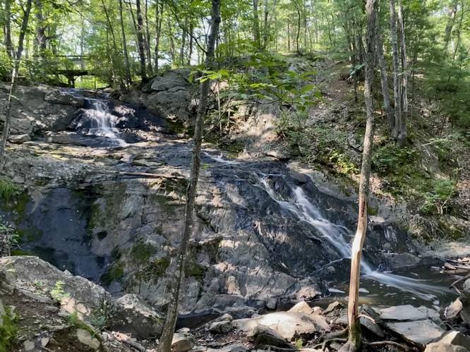
Jewell Falls at Fore River Sanctuary in Portland, Maine is an easy 0.4-mile out-and-back hike that leads to the 30-foot tall multi-tiered waterfall known as Jewell Falls.

Hike Description
This short hike begins at the parking lot for Fore River Sanctuary, located at the end of Hill Crest Ave in Portland. Hikers will find the trailhead located on the western side of the road. The trail follows a dirt path that leads into the Fore River Sanctuary as it passes neighboring private properties, so please be respectful of the private land owners and stay on-trail at all times.

The trail follows white blazes that lead out to a wooden footbridge that crosses the top of Jewell Falls. Hikers will follow the stone staircase down the hill to reach the base of the waterfall. From the bottom, hikers can enjoy Jewell Falls as it cascades down a series of bedrock slopes forming the scenic waterfall.

After enjoying Jewell Falls, hikers can choose to explore more of the Fore River Sanctuary on foot or head out along this out-and-back path.

Parking
Hikers will find parking at the coordinates provided - at the end of Hill Crest Ave in Portland. Be mindful of the private land owners - be quiet, don't stick around for long, and stay on-trail at all times near the trailhead.

Pets
Dogs are allowed only if leashed and must be cleaned up after.
Explore 32 trails near Portland, ME
  1. Parking

    43.671871, -70.316566
  2. Main Trailhead

    43.671898, -70.316693
  3. Jewell Falls, 30-feet tall

    43.670479, -70.318227
    Jewell Falls, 30-feet tall
No community routes found. To add your own hike as a Community Route for this Trail guide, leave a Trip Report with an attached GPX file.

Hazards

Ticks - Lyme Disease More Info (CDC)
Poison Ivy/Oak

Seasons

All

Blaze Color

White

Trip Reports

Trail Guide By:
Admin user profile picture
0.4 miles / 0.6 km
0.4 miles / 0.6 km
July 24, 2023
Hiking

Weather Forecast

In Portland, ME

Explore Hiking Trails

You May Also Like

Colorado's Million Dollar Highway - Plan a day's drive adventure along the iconic Million Dollar Highway in Colorado. Explore the best short trails, roadside stops, waterfalls, vistas, ghost towns, and hot springs within a ~6 hour road trip.
Explore

Colorado's Million Dollar Highway

Plan a day's drive adventure along the iconic Million Dollar Highway in Colorado. Explore the best short trails, roadside stops, waterfalls, vistas, ghost towns, and hot springs within a ~6 hour road trip.

Read
Glacier's Going-to-the-Sun Road - Discover the breathtaking beauty of Glacier National Park along the iconic Going-to-the-Sun Road. From stunning roadside stops to picturesque waterfalls and vistas, this engineering marvel offers endless opportunities for exploration.
Explore

Glacier's Going-to-the-Sun Road

Discover the breathtaking beauty of Glacier National Park along the iconic Going-to-the-Sun Road. From stunning roadside stops to picturesque waterfalls and vistas, this engineering marvel offers endless opportunities for exploration.

Read
New York's Best Waterfalls - Whether you're planning a day hike, roadside stop, or a leisurely short walk, this guide provides hikers, travelers, and locals alike with 63 different locations to over 100 scenic waterfalls to help plan your next adventure!
Explore

New York's Best Waterfalls

Whether you're planning a day hike, roadside stop, or a leisurely short walk, this guide provides hikers, travelers, and locals alike with 63 different locations to over 100 scenic waterfalls to help plan your next adventure!

Read

Before you boogie...

Find our trail guides useful? Consider becoming a Supporter to unlock perks!

MyHikes is an indie platform that makes exploring public trails easier for everyone. The platform has no investors, no ads, and is owned and operated by one person, Dave Miller. Dave has personally mapped and written over 1,800 trail guides on MyHikes for the public to explore. MyHikes has helped millions outdoor enthusiasts plan their next adventure.

But it takes a lot of time ๐Ÿ•ฆ, money ๐Ÿ’ฐ, work, and espresso shots โ˜• to run MyHikes, including hiking , mapping , writing , and publishing new trails with high-quality (accurate) information... along with software engineering (coding) the platform like building new features, website and mobile app development (iOS and Android), site maintainance . and much much more.

Supporters unlock website and mobile app perks with an annual one-time payment of $25 (you renew) ๐Ÿ˜Ž๐Ÿ‘. Or you can simply make a Donation of your choice. Otherwise, you can support us by telling your friends about MyHikes - both quick and free ๐ŸŽ‰

Admin user profile picture

Dave Miller
MyHikes Founder