Loading...

๐ŸŽ† 50% off 4th of July sale on Supporter Accounts โ€” now through July 6! Learn More.

Jerimoth Hill Trail

Directions
Map
Pictures
Send to App
Distance:
0.3 Miles / 0.5 km
Type:
Out-and-Back
Difficulty:
Easy
Time to Hike:
~9 minutes
Features:
Surface Type:
Dirt
Town:
Foster, Rhode Island
Directions:
41.851093, -71.779292
Added:
April 04, 2023
Updated:
April 08, 2023
Copy Trail Link Hiking this trail? Send a friend or family member a link to this trail guide for your own safety. Hike at your own risk (disclaimer)
Loading...
Loading...
27'

Total Change
27'

Ascent
27'

Descent

Download the Trail Route for Offline Use

Supporters get exclusive access to download trail routes to the MyHikes app for offline use. Stay prepared on your adventure, even without an internet connection! Become a Supporter today to unlock this feature and hike with confidence.

Send to App

Jerimoth Hill Trail

The Jerimoth Hill Trail in Foster, Rhode Island is an easy 0.3-mile out-and-back hike that leads to Rhode Island's highest point atop Jerimoth Hill's summit and features two survey markers, a trail registry, and a small bedrock outcropping.

Hike Description
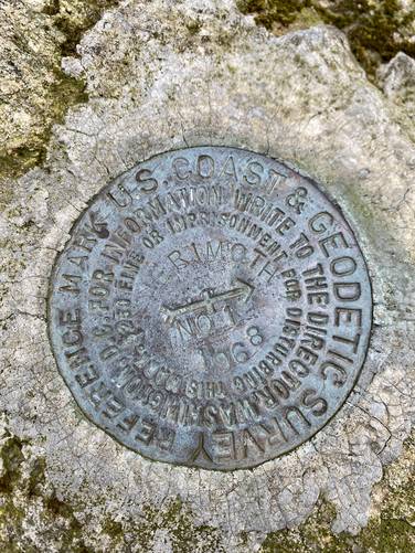
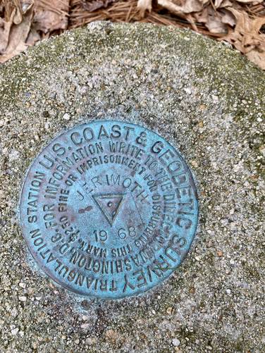
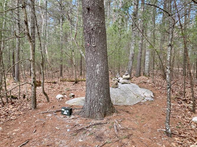
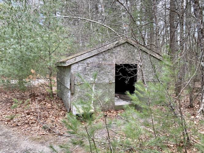
This short hike begins along RH-101 (Hartford Pike) near the parking coordinates provided and follows the well-defined trail south toward the summit of Jerimoth Hill. The trail starts by passing some very old and very tall rhododendrons located just beyond the trailhead gate. Following the "Jerimoth Hill" signs heading south, hikers will pass a U.S. Coast & Geodetic Survey marker around mile 0.07 and then another around mile 0.09 - the 2nd survey marker appears to be the "summit" marker. Hikers can continue down the trail a bit further to find a trail registry box tied to a tree sitting adjacent to a small bedrock outcropping where hikers have built small stone cairns on top. Here is where the hike ends - hikers can sign the trail registry, hop on the bedrock outcropping, or poke around the abandoned shacks and utility sheds that sit near the rocky outcropping.

Parking
Hikers will find parking on either side of RH-101 near the coordinates provided. There's enough parking for several vehicles on either side of the road.

Pets
Dogs are allowed if leashed and must be cleaned up after.
Explore 6 trails near Foster, RI
  1. Parking

    41.851093, -71.779292
  2. Main Trailhead

    41.851126, -71.779209
  3. US Coast & Geodetic Survey marker

    41.850281, -71.779008
    US Coast & Geodetic Survey marker
  4. Jerimoth Hill's US Coast & Geodetic Survey marker

    41.849972, -71.779083
    Jerimoth Hill's US Coast & Geodetic Survey marker
  5. Trail registry, bedrock outcropping, and storn cairns on Jerimoth Hill

    41.849194, -71.779306
    Trail registry, bedrock outcropping, and storn cairns on Jerimoth Hill
  6. Abandoned shack on Jerimoth Hill

    41.849036, -71.779372
    Abandoned shack on Jerimoth Hill
No community routes found. To add your own hike as a Community Route for this Trail guide, leave a Trip Report with an attached GPX file.

Hazards

Ticks - Lyme Disease More Info (CDC)
Poison Ivy/Oak

Seasons

All

Trip Reports

Trail Guide By:
Admin user profile picture
0.3 miles / 0.5 km
0.3 miles / 0.5 km
March 31, 2023
Dogs Hiking

Weather Forecast

In Foster, RI

Explore Hiking Trails

You May Also Like

Colorado's Million Dollar Highway - Plan a day's drive adventure along the iconic Million Dollar Highway in Colorado. Explore the best short trails, roadside stops, waterfalls, vistas, ghost towns, and hot springs within a ~6 hour road trip.
Explore

Colorado's Million Dollar Highway

Plan a day's drive adventure along the iconic Million Dollar Highway in Colorado. Explore the best short trails, roadside stops, waterfalls, vistas, ghost towns, and hot springs within a ~6 hour road trip.

Read
Glacier's Going-to-the-Sun Road - Discover the breathtaking beauty of Glacier National Park along the iconic Going-to-the-Sun Road. From stunning roadside stops to picturesque waterfalls and vistas, this engineering marvel offers endless opportunities for exploration.
Explore

Glacier's Going-to-the-Sun Road

Discover the breathtaking beauty of Glacier National Park along the iconic Going-to-the-Sun Road. From stunning roadside stops to picturesque waterfalls and vistas, this engineering marvel offers endless opportunities for exploration.

Read
New York's Best Waterfalls - Whether you're planning a day hike, roadside stop, or a leisurely short walk, this guide provides hikers, travelers, and locals alike with 63 different locations to over 100 scenic waterfalls to help plan your next adventure!
Explore

New York's Best Waterfalls

Whether you're planning a day hike, roadside stop, or a leisurely short walk, this guide provides hikers, travelers, and locals alike with 63 different locations to over 100 scenic waterfalls to help plan your next adventure!

Read

Before you boogie...

Find our trail guides useful? Consider becoming a Supporter to unlock perks!

MyHikes is an indie platform that makes exploring public trails easier for everyone. The platform has no investors, no ads, and is owned and operated by one person, Dave Miller. Dave has personally mapped and written over 1,800 trail guides on MyHikes for the public to explore. MyHikes has helped millions outdoor enthusiasts plan their next adventure.

But it takes a lot of time ๐Ÿ•ฆ, money ๐Ÿ’ฐ, work, and espresso shots โ˜• to run MyHikes, including hiking , mapping , writing , and publishing new trails with high-quality (accurate) information... along with software engineering (coding) the platform like building new features, website and mobile app development (iOS and Android), site maintainance . and much much more.

Supporters unlock website and mobile app perks with an annual one-time payment of $25 (you renew) ๐Ÿ˜Ž๐Ÿ‘. Or you can simply make a Donation of your choice. Otherwise, you can support us by telling your friends about MyHikes - both quick and free ๐ŸŽ‰

Admin user profile picture

Dave Miller
MyHikes Founder