Loading...

🍂 Prep for Fall! Unlock exclusive features to plan your perfect late-summer and autumn hikes — become a Supporter today. Learn more.

Jeremy's Run Hike

Directions
Map
Pictures
Send to App
Distance:
14.0 Miles / 22.5 km
Type:
Loop
Difficulty:
Hard
Time to Hike:
7 hours
Features:
Appalachian Trail hike
Surface Type:
Dirt
Park:
Shenandoah National Park
Town:
Fourway, Virginia
Directions:
38.740797, -78.312006
Added:
March 18, 2025
Updated:
April 05, 2025
Guide by:
Copy Trail Link Hiking this trail? Send a friend or family member a link to this trail guide for your own safety. Hike at your own risk (disclaimer)
Loading...
Loading...
1,699'

Total Change
2,704'

Ascent
2,705'

Descent

Download the Trail Route for Offline Use

Supporters get exclusive access to download trail routes to the MyHikes app for offline use. Stay prepared on your adventure, even without an internet connection! Become a Supporter today to unlock this feature and hike with confidence.

Send to App

Key Takeaways

  • Jeremy's Run Loop is a challenging 14.7-mile hike in Shenandoah National Park (SNP) with 14 stream crossings that can be difficult during high water.
  • The hike offers scenic views from the Neighbor Mountain Trail, including vistas of Kennedy Peak, Duncan Knob, and the Three Sisters Ridge.
  • The trail passes a noteworthy waterfall and a large campsite (though open campfires are prohibited in SNP).

Jeremy's Run Hike

At 14.7 miles the Jeremy's Run loop is one of the longest in the SNP. On the Neighbor Mountain Trail there are several beautiful views to the west of Kennedy Peak, Duncan Knob, and the Three Sisters Ridge just to the south. Also with 14 crossings of Jeremy's Run this hike can be a challenge in the spring when the water is at its highest level.

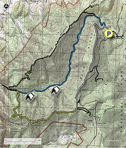
From the parking area start down the connector trail where it shortly joins the white blazed Appalachian Trail (AT). Continue downward on the white blazed AT and in 0.3 miles arrive at the intersection of the blue blazed Jeremy's Run Trail that continues downward.

Turn left remaining on the white blazed AT as it it climbs Blue Ridge. In 2.3 miles from the Jeremy's Run intersection arrive at the Blue Ridge high point, and a trail intersection that leads to the Thorton River Trail. Remain south/straight on the white blazed AT following the ridgeline for another 1.3 miles to the next intersection that leads to a Skyline Drive parking area. Again stay on the AT, and in 0.2 miles reach the four way intersection with the Neighbor Mountain Trail.

Turn right on the yellow blazed Neighbor Mountain Trail as it begins to gradually descend the Neighbor Mountain ridgeline. In 2.0 miles there are views of Three Sisters Ridge just to the south, then in another 0.9 miles views of Kennedy Peak and Duncan Knob across the valley to the west on the Massanutten Range.

The trail will now descend more steeply, making several switchbacks before arriving at Jeremy's Run in another 1.1 miles. Turn right upstream on the blue blazed Jeremy's Run Trail, and in 0.2 miles make the first of 14 stream crossings.

After crossing Jeremy's Run, continue on the blue blazed trail for 0.4 mile to the best waterfall on the hike, and on the opposite bank a large group campsite. Open campfires are not permitted in the SNP, but this is still one great camping spot at the top of a beautiful set of falls.

After passing the falls, the Jeremy's Run Trail will continue for 4.3 miles crossing the stream 13 more times before arriving at the intersection of the Knob Mountain Cutoff Trail. Continue straight on the Jeremy's Run Trail as it now becomes steeper for the 0.8 miles back to the intersection of the white blazed AT, and where the Jeremy's Run Trail ends.

Remain straight/uphill on the now white blazed AT for the remaining 0.3 miles back to the parking area.

Explore 99 trails near Fourway, VA
  1. Parking

    38.740797, -78.312006
  2. Main Trailhead

    38.74103, -78.312006
No community routes found. To add your own hike as a Community Route for this Trail guide, leave a Trip Report with an attached GPX file.

Hazards

Ticks - Lyme Disease More Info (CDC)
Snakes
Poison Ivy/Oak

Seasons

All

Photo Albums

+ Add Photo Album

Upload your photos from the trail to help others know what to expect.

Trip Reports (Reviews)

Rated 4.02 out of 5 based on 52 ratings.
By: Grand Feather
14.0 miles / 22.5 km
July 27, 2019
I have done this hike in spring, summer and winter. It is best IMHO in spring when the mountain laurel is blooming. There was a fire on Neighbor Mountain several years ago. The area is recovering but due to the fire there is a significant amount of plant diversity for plant lovers and great views. I have also done Neighbor Mountain-Knob Mountain as a loop. This is best in in spring or winter when you can see out. Knob Mountain is along a ridge with nice views in two directions. The hike is strenuous for those that do not hike regularly. The Knob Mountain option adds about 600 additional feet or more of elevation gain. On my last trip I was lucky enough to see two black bears and lots of bear scat on the trail. It is best to wear long pants on this trail as it does not get lots of use and at times is overgrown with raspberries, black berries and poison ivy in spots. I did not see lots of poison ivy but enough to make me cautious and careful in shorts.
Legacy Review
By: Taylor
14.0 miles / 22.5 km
June 15, 2019
Just like others who have left reviews before me, I feel like this has the potential to be a great hike in the winter. In the middle of the summer, however, I wouldn't recommend it. The portion of the hike that followed through the AT was nice, but as we approached the Neighbor Mountain trail, the trail grew more and more overgrown until it was impossible to pass without walking straight through poison ivy. After I gave up trying to avoid the poison ivy and just accepted my itchy fate, the hike was fairly enjoyable. My group caught a couple of ticks, which is never fun but inevitable given the amount of brush we walked through. Definitely recommend treating your clothes and shoes with permethrin / taking as many precautions as you can. The weather was perfect and the water wasn't too high so stream crossings were enjoyable. Definitely not a strenuous hike, just a nice, long walk in the woods.
Legacy Review
By: Kevin G.
14.0 miles / 22.5 km
January 08, 2019
A group of us did this hike during the Government shutdown and they are still open, the directions provided were very clear. During the shutdown, the road to the parking lot to Jeremy's parking lot was closed off, so we just parked at the Elkwallow Picnic Grounds parking lot, which was no big deal. We simply just walked to the jeremy's run entrance. The trail was well blazed. While the description noted, "best waterfall on the hike," this served as a reference point for the first campsite, which we missed because of the description "best." I would note the waterfall appeared to be probably no more than 10 ft. I believe we did see the campsite, but were misled with the description of the waterfall. Fortunately, we found the next site shortly after, which was slightly off the trail. Overall, the hike was a good one, the river crossings were quite a challenge. It was certainly fun just counting them. Some of the crossings, you could do hopping on rocks, several others we took off boots or carefully crossed different regions of the crossing. I would recommend hiking poles to help with balanced. They were certainly proven handy at the time. We did this hike in 2 days, majority of the hike on day 1, and the water source was plentiful since it was along the river.
Legacy Review

Weather Forecast

In Fourway, VA

Explore Hiking Trails

You May Also Like

New York's Best Waterfalls - Whether you're planning a day hike, roadside stop, or a leisurely short walk, this guide provides hikers, travelers, and locals alike with 63 different locations to over 100 scenic waterfalls to help plan your next adventure!
Explore

New York's Best Waterfalls

Whether you're planning a day hike, roadside stop, or a leisurely short walk, this guide provides hikers, travelers, and locals alike with 63 different locations to over 100 scenic waterfalls to help plan your next adventure!

Read
25 Best Day Hikes in North Carolina - Discover the top 25 best day hikes in North Carolina, from breathtaking waterfalls to mountain peaks. Explore hidden gems, scenic views, and trails suitable for all skill levels, perfect for your next outdoor adventure.
Explore

25 Best Day Hikes in North Carolina

Discover the top 25 best day hikes in North Carolina, from breathtaking waterfalls to mountain peaks. Explore hidden gems, scenic views, and trails suitable for all skill levels, perfect for your next outdoor adventure.

Read

Before you boogie...

Find our trail guides useful? Consider becoming a Supporter to unlock perks!

MyHikes is an indie platform that makes exploring public trails easier for everyone. The platform has no investors, no ads, and is owned and operated by one person, Dave Miller. Dave has personally mapped and written over 1,800 trail guides on MyHikes for the public to explore. MyHikes has helped millions outdoor enthusiasts plan their next adventure.

But it takes a lot of time 🕦, money 💰, work, and espresso shots ☕ to run MyHikes, including hiking , mapping , writing , and publishing new trails with high-quality (accurate) information... along with software engineering (coding) the platform like building new features, website and mobile app development (iOS and Android), site maintainance . and much much more.

Supporters unlock website and mobile app perks with an annual one-time payment of $25 (you renew) 😎👍. Or you can simply make a Donation of your choice. Otherwise, you can support us by telling your friends about MyHikes - both quick and free 🎉

Admin user profile picture

Dave Miller
MyHikes Founder