Loading...

🎉 Enjoy a Free 7-Day Supporter Trial and Unlock Exclusive Perks — No Credit Card Required. Learn more.

Jawbone Overlook Hike

Directions
Map
Pictures
Send to App
Distance:
2.5 Miles / 4.0 km
Type:
Out-and-Back
Difficulty:
Moderate
Time to Hike:
1 hour, ~15 minutes
Features:
Surface Type:
Dirt
Park:
George Washington National Forest
Town:
Mount Jackson, Virginia
Directions:
38.708513, -78.560516
Added:
January 27, 2025
Updated:
April 04, 2025
Copy Trail Link Hiking this trail? Send a friend or family member a link to this trail guide for your own safety. Hike at your own risk (disclaimer)
Loading...
Loading...
861'

Total Change
903'

Ascent
895'

Descent

Download the Trail Route for Offline Use

Supporters get exclusive access to download trail routes to the MyHikes app for offline use. Stay prepared on your adventure, even without an internet connection! Become a Supporter today to unlock this feature and hike with confidence.

Send to App

Jawbone Overlook Hike

Jawbone Overlook starting from from Crisman Hollow Rd is a short hike with a big payoff, and sees very little traffic compared to other close by hikes. On a clear day the view easterly from Jawbone Overlook is spectacular. Kennedy Peak is visible to the northwest, with Duncan Knob on the southern tip of Catback Mountain to the east. Don't be surprised if you have this beautiful overlook all to yourself. Jawbone Overlook is just north of New Market Gap in the Massanutten Range, and close to the Duncan Knob and Strickler Knob hikes.

If you feel like bagging another spectacular overlook while you're in the area, as well as adding a fun rock scramble, the Gap Creek trailhead that climbs up to Duncan Knob starts only 75 yards further south on Crisman Hollow Rd.

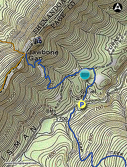
  • Mile 0.0 - From the parking area on Crisman Hollow Road pass the closed gate and start uphill on the blue blazed Jawbone Gap Trail. The trail initially follows a wide gravel fire road passing a wildlife clearing then arrives at an intersection where the blue blazed trail turns left.
  • Mile 0.26 - Turn left off the gravel road onto an old forestry road following the blue blazes.
  • Mile 0.3 - Pass a seasonal spring fed pond. The pond is exceptionally clear when the spring is flowing. Continue on the forestry road and stay right where the road splits
  • Mile 0.6 - Make the first switchback, and now continue more steeply.
  • Mile 0.76 - Make a switchback to the left, then in 75 yards the blue blazed Jawbone Gap Trail makes another sharp switchback to the right and leaves the forestry road. The trail is now a narrow hiking trail and will switchback two more times then climb to the ridge and intersection of the orange blazed Massanutten and white blazed Jawbone Overlook trails.
  • Mile 1.0 - At the ridge the orange blazed Massanutten trail turns left as well as continuing straight. Turn right on the white blazed Jawbone Overlook Trail north along the ridge. The trail passes over a rocky area, then continues more steeply towards Jawbone Overlook.
  • Mile 1.25 - Arrive at the overlook. To return re-trace your route.
  • Mike 2.5 - Arrive back at the parking area on Crisman Hollow Rd.
Explore 99 trails near Mount Jackson, VA
  1. Parking

    38.708513, -78.560516
  2. Main Trailhead

    38.70895, -78.559635
No community routes found. To add your own hike as a Community Route for this Trail guide, leave a Trip Report with an attached GPX file.

Hazards

Ticks - Lyme Disease More Info (CDC)
Snakes

Seasons

All

Blaze Color

Blue

Trip Reports

Trail Guide By:
HikingUpward user profile picture
2.5 miles / 4.0 km

Weather Forecast

In Mount Jackson, VA

Explore Hiking Trails

You May Also Like

New York's Best Waterfalls - Whether you're planning a day hike, roadside stop, or a leisurely short walk, this guide provides hikers, travelers, and locals alike with 63 different locations to over 100 scenic waterfalls to help plan your next adventure!
Explore

New York's Best Waterfalls

Whether you're planning a day hike, roadside stop, or a leisurely short walk, this guide provides hikers, travelers, and locals alike with 63 different locations to over 100 scenic waterfalls to help plan your next adventure!

Read
25 Best Day Hikes in North Carolina - Discover the top 25 best day hikes in North Carolina, from breathtaking waterfalls to mountain peaks. Explore hidden gems, scenic views, and trails suitable for all skill levels, perfect for your next outdoor adventure.
Explore

25 Best Day Hikes in North Carolina

Discover the top 25 best day hikes in North Carolina, from breathtaking waterfalls to mountain peaks. Explore hidden gems, scenic views, and trails suitable for all skill levels, perfect for your next outdoor adventure.

Read

Before you boogie...

Find our trail guides useful? Consider becoming a Supporter to unlock perks!

MyHikes is an indie platform that makes exploring public trails easier for everyone. The platform has no investors, no ads, and is owned and operated by one person, Dave Miller. Dave has personally mapped and written over 1,800 trail guides on MyHikes for the public to explore. MyHikes has helped millions outdoor enthusiasts plan their next adventure.

But it takes a lot of time 🕦, money 💰, work, and espresso shots ☕ to run MyHikes, including hiking , mapping , writing , and publishing new trails with high-quality (accurate) information... along with software engineering (coding) the platform like building new features, website and mobile app development (iOS and Android), site maintainance . and much much more.

Supporters unlock website and mobile app perks with an annual one-time payment of $25 (you renew) 😎👍. Or you can simply make a Donation of your choice. Otherwise, you can support us by telling your friends about MyHikes - both quick and free 🎉

Admin user profile picture

Dave Miller
MyHikes Founder