The Island Park River Walk at Island Park in Blossburg, Pennsylvania is an easy 1-mile universal access gravel trail that encompasses Island Park and features views of the Tioga River.
Trail Description
This recording heads in a counter-clockwise loop starting from the parking lot. The trail first passes the skatepark as it passes through a grove of tall white pine trees. Along the way, walkers will find self-guided tree identification plaques which can be fully appreciated when the leaves are on the trees.
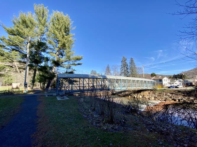
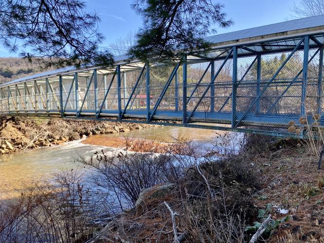
McIntyre Street Bridge - Mile 0.3
At mile 0.3, walkers will reach a blue metal bridge that crosses the Tioga River and connects to McIntyre Street.
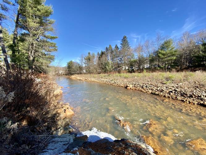
Red Slab Falls - Mile 0.3
Just under the McIntyre Street Bridge lies a large red slab of bedrock that sits in the Tioga River. While this slab of bedrock is more like a rapid and less like a waterfall, this is the only waterfall you'll see along the hike - it's over 20-feet wide and gradually slopes down at about 2-feet tall, making for a somewhat scenic waterfall along the walk.
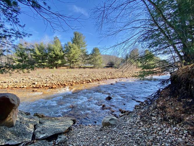
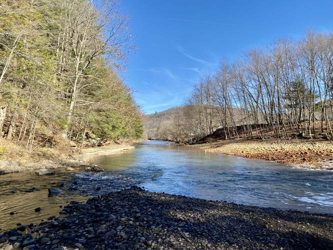
Tioga River View - Mile 0.43
At mile 0.43, walkers will reach an off-trail view of the Tioga River, right where a tributary creek spills in. At the foreground are some large rocks that sit above what appears to be a swimming hole or fishing hole just across the tributary creek. Here, walkers can enjoy a nice view of the Tioga River and the surrounding mountains.
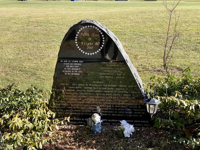
Plane Crash Memorial - Mile 0.55
At mile 0.55, walkers will reach a memorial site dedicated to the lives lost on June 23, 1967 when a plane crashed 1-mile east of here. There were no survivors; however, the memorial includes each of their names.
After passing the plane crash memorial, the trail will pass the football field before taking a slight-turn to continue heading south along a less-scenic part of the trail. Here is where the tributary creek that feeds the Tioga River becomes smaller and smaller. The trail eventually reaches a 2-way turn where heading left will head back to the baseball fields and the parking lot to complete the 1-mile loop.
Universal Access
Note that this trail is universally-accessible. The trail is made of fine crushed gravel, with no stairs and no ramps. Walkers and visitors can get on the trail directly from the parking lot and the elevation grade is not noticeable over the course of 1-mile. The only sections of the trail that are not universally-accessible are the off-trail views of the Tioga River; however, you can still appreciate more obstructed views of the river from on-trail.
Parking
Walkers will find a small parking lot at the coordinates provided. The lot is large enough to fit about 10 vehicles.
Pets
Dogs are allowed if leashed and their waste must be cleaned up by the walker. Doggy bags and trash receptacles can be found in numerous places along the trail.
Views
While there are no lookout points along this trail, there are a couple of off-trail spots with views of the Tioga River. When the leaves are off of the trees, walkers don't need to go out of their way to enjoy a view of the river. Note that in the northeast corner of the trail, where the Tioga River meets with a tributary creek, there's a nice view of the river with the surrounding mountains.
Amenities:
Skatepark: Island Park has a public skatepark, which is a unique opportunity for local skateboarders are the next closest park is about 1-hour away. Albeit the park is small, there's a rollin ramp, quarter pipe, small-sized fun box, some rind rails, and a grind box available as of Nov, 2022.
Games: There's one stone cornhole board setup and horseshoes along the Tioga Rive side of the trail, close to the parking lot.
Grills, picnic areas: There are grills and picnic areas available along the Tioga River side of the trail.
Trail Description
This recording heads in a counter-clockwise loop starting from the parking lot. The trail first passes the skatepark as it passes through a grove of tall white pine trees. Along the way, walkers will find self-guided tree identification plaques which can be fully appreciated when the leaves are on the trees.
McIntyre Street Bridge - Mile 0.3
At mile 0.3, walkers will reach a blue metal bridge that crosses the Tioga River and connects to McIntyre Street.
Red Slab Falls - Mile 0.3
Just under the McIntyre Street Bridge lies a large red slab of bedrock that sits in the Tioga River. While this slab of bedrock is more like a rapid and less like a waterfall, this is the only waterfall you'll see along the hike - it's over 20-feet wide and gradually slopes down at about 2-feet tall, making for a somewhat scenic waterfall along the walk.
Tioga River View - Mile 0.43
At mile 0.43, walkers will reach an off-trail view of the Tioga River, right where a tributary creek spills in. At the foreground are some large rocks that sit above what appears to be a swimming hole or fishing hole just across the tributary creek. Here, walkers can enjoy a nice view of the Tioga River and the surrounding mountains.
Plane Crash Memorial - Mile 0.55
At mile 0.55, walkers will reach a memorial site dedicated to the lives lost on June 23, 1967 when a plane crashed 1-mile east of here. There were no survivors; however, the memorial includes each of their names.
After passing the plane crash memorial, the trail will pass the football field before taking a slight-turn to continue heading south along a less-scenic part of the trail. Here is where the tributary creek that feeds the Tioga River becomes smaller and smaller. The trail eventually reaches a 2-way turn where heading left will head back to the baseball fields and the parking lot to complete the 1-mile loop.
Universal Access
Note that this trail is universally-accessible. The trail is made of fine crushed gravel, with no stairs and no ramps. Walkers and visitors can get on the trail directly from the parking lot and the elevation grade is not noticeable over the course of 1-mile. The only sections of the trail that are not universally-accessible are the off-trail views of the Tioga River; however, you can still appreciate more obstructed views of the river from on-trail.
Parking
Walkers will find a small parking lot at the coordinates provided. The lot is large enough to fit about 10 vehicles.
Pets
Dogs are allowed if leashed and their waste must be cleaned up by the walker. Doggy bags and trash receptacles can be found in numerous places along the trail.
Views
While there are no lookout points along this trail, there are a couple of off-trail spots with views of the Tioga River. When the leaves are off of the trees, walkers don't need to go out of their way to enjoy a view of the river. Note that in the northeast corner of the trail, where the Tioga River meets with a tributary creek, there's a nice view of the river with the surrounding mountains.
Amenities:
Skatepark: Island Park has a public skatepark, which is a unique opportunity for local skateboarders are the next closest park is about 1-hour away. Albeit the park is small, there's a rollin ramp, quarter pipe, small-sized fun box, some rind rails, and a grind box available as of Nov, 2022.
Games: There's one stone cornhole board setup and horseshoes along the Tioga Rive side of the trail, close to the parking lot.
Grills, picnic areas: There are grills and picnic areas available along the Tioga River side of the trail.