Loading...

🎆 50% off 4th of July sale on Supporter Accounts — now through July 6! Learn More.

Indian Grave Ridge Hike

Directions
Map
Pictures
Send to App
Distance:
8.3 Miles / 13.4 km
Type:
Loop
Difficulty:
Moderate
Time to Hike:
4 hours, ~9 minutes
Features:
Surface Type:
Dirt
Park:
George Washington National Forest
Town:
Compton, Virginia
Directions:
38.807749, -78.387028
Added:
January 27, 2025
Updated:
April 04, 2025
Copy Trail Link Hiking this trail? Send a friend or family member a link to this trail guide for your own safety. Hike at your own risk (disclaimer)
Loading...
Loading...
1,387'

Total Change
1,624'

Ascent
1,621'

Descent

Download the Trail Route for Offline Use

Supporters get exclusive access to download trail routes to the MyHikes app for offline use. Stay prepared on your adventure, even without an internet connection! Become a Supporter today to unlock this feature and hike with confidence.

Send to App

Indian Grave Ridge Hike

The Indian Grave Ridge circuit combines portions of VA 717, Toliver, Milford Gap, Massanutten, and Indian Grave Ridge trails, and is one of the least hiked circuits in the Massanutten range. This is probably due to people being put off by the VA 717 road walk. However the gravel road here sees very little traffic as it ends in another mile. This section of VA 717 is also is a pleasant walk beside the Shenandoah River. During the summer months you will see many people tubing and canoeing along this section.

The majority of the trails offer beautiful vistas through the trees of both the Shenandoah River to the east, and Fort Valley to the west. If you're hiking this as a backpack there is a large campsite on the Massanutten Trail that has views to the east. Just make sure to bring plenty of water as there are no easily accessible springs along this route.

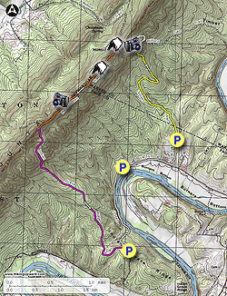
There are also three potential parking locations. The first is just off VA 717 at the Indian Grave Ridge trailhead but requires a high clearance vehicle when rutted. The second (recommended) is at the closed boat ramp on VA 717, and the third is at the Toliver trailhead.

  • Mile 0.0 - From the the closed boat ramp parking area head north and walk along VA 717. The road is wide and sees very little traffic. There are nice views of the Shenandoah National Park towards Overall Run.

  • Mile 0.7 - Turn left uphill on VA 236 and follow the road for 0.35 miles to the Toliver trailhead and parking area.

  • Mile 1.05 - The Toliver Trail is yellow blazed. Pass around a closed gate where for the first 1.24 miles the trail is part of a forestry road. As the trail climbs Massanutten Mountain it will make two large sweeping turns. First to the left and then back to the right.

  • Mile 2.29 - The forestry road will end at a large turnaround. Turn left uphill and pass around another closed gate continuing to follow the yellow blazed Toliver Trail as it heads more directly uphill.

  • Mile 2.81 - In 0.52 miles the Toliver Trail ends at the junction with the while blazed Milford Gap Trail. Stay left uphill on the Milford Gap Trail. In 0.5 miles pass view of the Shenandoah River to the east through a break in the trees shortly before arriving at the ridge.

  • Mile 3.43 - Arrive at the ridge and intersection of the orange blazed Massanutten Trail. There is a small campsite at the intersection, and the Milford Gap Trail now continues downhill on the western side of the mountain. Turn left/south on the Massanutten Trail is it follows the ridge. There are numerous views of both the Luray Valley to the east and Fort Valley to the west.

  • Mile 3.79 - Pass a large, and best campsite, on the hike. Continue on the Massanutten Trail for another 0.73 miles passing an excellent westerly view of Fort Valley. From this overlook it is 0.34 miles to the next intersection.

  • Mile 4.88 - Pass a old hiking trail on the right, staying left on the Massanutten Trail.

  • Mile 4.96 - Arrive at the intersection with the purple blazed Indian Grave Ridge Trail. Turn left/east downhill as the trail initially descends very steeply for the first 0.75 miles. Pass through a small saddle on the ridge and continue downhill until the Indian Grave Ridge Trail turns left at an intersection with another old hiking trail.

  • Mile 6.42 - Turn left staying on the purple blazed Indian Grave Trail for 1.06 miles where the trail passes around a closed gate and ends at the trailhead parking area. Walk 75 yards to VA 717.

  • Mile 7.49 - Turn left and walk north along VA 717. The road will descend towards the Shenandoah River where it levels out for the remainder of the hike.

  • Mile 8.6 - Arrive back at the closed boat ramp parking area.
Explore 97 trails near Compton, VA
  1. Parking

    38.807749, -78.387028
  2. Main Trailhead

    38.807749, -78.387028
No community routes found. To add your own hike as a Community Route for this Trail guide, leave a Trip Report with an attached GPX file.

Hazards

Ticks - Lyme Disease More Info (CDC)
Snakes

Seasons

All

Trip Reports

Trail Guide By:
HikingUpward user profile picture
8.3 miles / 13.4 km

Weather Forecast

In Compton, VA

Explore Hiking Trails

You May Also Like

New York's Best Waterfalls - Whether you're planning a day hike, roadside stop, or a leisurely short walk, this guide provides hikers, travelers, and locals alike with 63 different locations to over 100 scenic waterfalls to help plan your next adventure!
Explore

New York's Best Waterfalls

Whether you're planning a day hike, roadside stop, or a leisurely short walk, this guide provides hikers, travelers, and locals alike with 63 different locations to over 100 scenic waterfalls to help plan your next adventure!

Read
25 Best Day Hikes in North Carolina - Discover the top 25 best day hikes in North Carolina, from breathtaking waterfalls to mountain peaks. Explore hidden gems, scenic views, and trails suitable for all skill levels, perfect for your next outdoor adventure.
Explore

25 Best Day Hikes in North Carolina

Discover the top 25 best day hikes in North Carolina, from breathtaking waterfalls to mountain peaks. Explore hidden gems, scenic views, and trails suitable for all skill levels, perfect for your next outdoor adventure.

Read

Before you boogie...

Find our trail guides useful? Consider becoming a Supporter to unlock perks!

MyHikes is an indie platform that makes exploring public trails easier for everyone. The platform has no investors, no ads, and is owned and operated by one person, Dave Miller. Dave has personally mapped and written over 1,800 trail guides on MyHikes for the public to explore. MyHikes has helped millions outdoor enthusiasts plan their next adventure.

But it takes a lot of time 🕦, money 💰, work, and espresso shots ☕ to run MyHikes, including hiking , mapping , writing , and publishing new trails with high-quality (accurate) information... along with software engineering (coding) the platform like building new features, website and mobile app development (iOS and Android), site maintainance . and much much more.

Supporters unlock website and mobile app perks with an annual one-time payment of $25 (you renew) 😎👍. Or you can simply make a Donation of your choice. Otherwise, you can support us by telling your friends about MyHikes - both quick and free 🎉

Admin user profile picture

Dave Miller
MyHikes Founder