The Impson Hollow hike at Susquehannock State Forest near Cross Fork, Pennsylvania is an easy 0.8-mile out-and-back trail that features an old CCC dynamite shed.
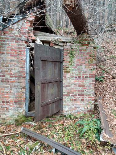
There are many historically points of interest that can be found in this area in the purlieus of the Ole Bull Castle site. In Impson Hollow, there is a brick and mortar building with a heavy iron door sitting along the Impson Hollow Branch of Joerg Run near the trailhead on the Joerg Road. This old building is located along the trail, several hundred feet upstream of the lower end of of access trail. This time-battered building has been substantially damaged from being impacted by a large tree blowdown hitting on it's wooden roof with metal roofing.
Hike Description
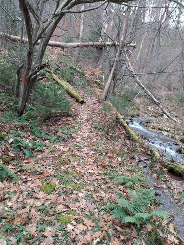
This hike follows an access trail on an unmarked, abandon roadway, that
is badly over-grown iwith brush and smaller trees along Impson Hollow
Branch of Joerg Run to the well-maintained Susquehannock Trail
System (orange blazes) at the upper end of Impson Hollow, and then
returns back on the same route to Joerg Rd.
Impson Hollow CCC-Era Dynamite Storage Shed
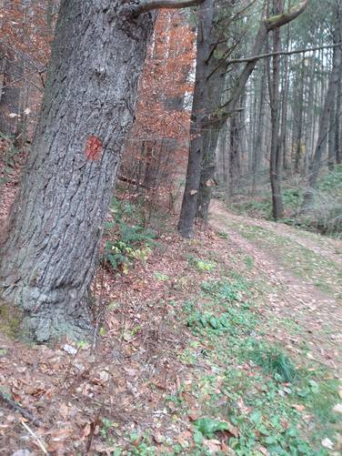
The access trail is an unmarked, abandon roadway, that is grown in somewhat with brush and smaller trees. This unmarked trail follows along the Impson Hollow Branch of Joerg Run for about one-half-of a mile starting near the trailhead on the Joerg Road and continues upstream to the where the hiker will find the Susquehannock Trail System aka STS (blazed orange) passes through the upper end of Impson Hollow.
It is believed that this structure, based on research done by Civilian Conservation Corps (CCC) Historian John Eastlake, was the dynamite storage building for CCC Camp S-87-PA at Ole Bull. In the early CCC program, the camps did not have bulldozers or other heavy equipment, so they used dynamite to break up stumps and rocks into pieces small enough to move out of the way with muscle power and hand tools. Dynamite storage facilities were always located at a safe distance from the CCC camps. The Ole Bull Camp was located near Kettle Creek at the intersection of Joerg Road and Ole Bull Road, about a mile away from the dynamite shed.
Parking
Hikers will find a small parking turnout near by the coordinates provided. The turnout is enough for 1 vehicle but no more without blocking traffic on the Joerg Road (which include large log trucks).
Do not block the public use of the Joerg Road, or any of the privately-leased cabin access roads, or any of the yellow-gated forest service roads in the area.
Pets
This unmarked trail is not maintained, but is not dog-friendly when the overgrowth is dead or low.
Biking
This unmarked trail is not maintained, and is not suitable for Biking. Additionally, horses and bikes are not allowed along the STS.
Camping and Backpacking
Although camping is allowed along trails in the Susquehannock State Forest, PA where state forest rules permit backcountry / dispersed / primitive camping. This unmarked trail is not maintained, and is not suitable for Camping and Backpacking. The Susquehannock Trail System aka STS is by far the best place to camp in this area; but it would be best for the camper to park at another pre-defined parking area for any extended hikes or overnight camping trips.
Hikers can find a large parking turnout near a yellow gate along the Twelve Mile Rd. where the STS crosses the Twelve Mile Rd. See Big Trestle Trail for extended trip parking coordinates and details. From this Twelve Mile Rd. parking area, the hiker can hike the STS going west toward Ole Bull park, and then hike down Impson hollow to find the old dynamite storage building for CCC Camp S-87-PA at Ole Bull.
History and Historical Points of Interest
Castle Vista Trail Ole Bornemann Bull (1810 - 1880), a once-famous Norwegian violinist, relocated a colony of fellow Norwegians near the site in September 1852. From this vantage point (Nordjeuskald), Ole Bull started to build his castle, but this large wooden cabin was never completed. All that remains today is the foundation and a stone retaining wall along the mountainside. The colony disbanded and moved west after a year of severe hardships.
Dense forests of magnificent white pine, hemlock and hardwoods grew here in Potter County for many decades. In the late 1800's and early 1900's, industrial saw mills, tanneries, and chemical plants were established, using wood or bark as raw materials which brought rapid population increases. As the hillsides became barren, the population spiraled downward with much of the deforested timberland abandoned, Before than, Native Americans had passed through the forested wilderness.
Ole Bull State Park was established in 1920. Civilian Conservation Corps Camp Ole Bull S-87-PA located in the Kettle Creek watershed was opened in the 1933 . Its servicemen constructed picnic shelters, dammed the creek for swimming, and assisted local foresters in fire control and reforestation of the land. The Camp Ole Bull closed in 1941.