Loading...

WINTER SALE! 50% OFF Supporter Accounts — now through January 31st. Learn More.

Iller Creek Loop

The Iller Creek Loop at Dishman Hills Conservation Area near Spokane, Washington is a difficult 4.8-mile loop trail that features sweeping views and granite monoliths, called the Rocks of Sharon.

The hike begins shrouded in ponderosa pines, but quickly ascends above the forest to panoramic views of the Washington Palouse, Spokane Valley, and Selkirk Mountains.

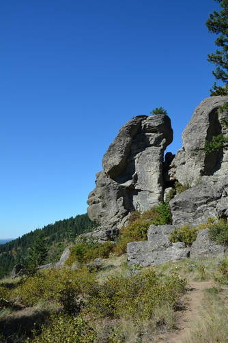
Rocks of Sharon / Big Rock - Mile 2.4
Around mile 2.4, hikers will reach "Big Rock" labeled on the official park map - this rock is also known as the Rocks of Sharon. Here, hikers get a south-facing view.

Also please see the official Dishman Hills Conservancy trail map for Iller Creek here.

Parking
Hikers will find parking at the coordinates provided near the trailhead.

Pets
Dogs are allowed if leashed and their waste must be carried out by the hiker.

Trail and photos provided in partnership by hike.io.

Know Before You Go

  • Iller Creek Loop is a challenging 4.8-mile hike in Spokane, WA, within the Dishman Hills Conservation Area.
  • The trail offers diverse scenery, transitioning from ponderosa pine forests to panoramic views of the Palouse, Spokane Valley, and Selkirk Mountains.
  • A major highlight is the "Rocks of Sharon" (Big Rock) around mile 2.4, providing a south-facing vista.
Interactive topographic map for Iller Creek Loop located in Spokane, WA. Click the "View Map" button to load GPS coordinates and trail markers.
Get directions
Distance
4.8 mi
Difficulty
Hard
Type
Loop
Est. Time
2.4 hrs
Elev. Gain
1,261'
Rating
0.0
Added
February 18, 2022
Updated
February 18, 2022

Weather Forecast

Loading...
Total Change
1,125'
Ascent
1,261'
Descent
1,253'
Loading...

Download the GPX Data for Offline Use

Supporters get exclusive access to download trail routes to the MyHikes app for offline use. Stay prepared on your adventure, even without an internet connection! Become a Supporter today to unlock this feature and hike with confidence.

Download Iller Creek Loop GPX Data to the MyHikes Mobile App

Features

Vista / Lookout Point
Dogs

Points of interest

  1. Parking

    47.601818, -117.281621
  2. Main Trailhead

    47.60183, -117.281799

Safety information

For your own safety: plan ahead, let someone know where you'll be, and hike at your own risk.

Hazards

Rockfalls, Ledges, or Scrambles

Availability

All seasons

Surface type

Dirt

Trip Reports (Reviews)

Your opinion matters! Be the first to rate this trail.

Ready to help fellow hikers? Add a trip report to share your experience and provide valuable insights for other hikers!

No community routes found. To add your own hike as a Community Route for this Trail guide, leave a Trip Report with an attached GPX file.

Popular categories

Scenic mountain view representing vista trails
Vista trails
Scenic gorge of cascades representing waterfall trails
Waterfall hikes
Rugged mountain terrain representing summit trails
Summit trails
Scenic mountain view representing dog-friendly trails
Dog-friendly
Scenic campsite with a view representing camping trails
Camping trails
Appalachian Trail logo representing A.T. hikes
A.T. hikes

You May Also Like

Glacier's Going-to-the-Sun Road - Discover the breathtaking beauty of Glacier National Park along the iconic Going-to-the-Sun Road. From stunning roadside stops to picturesque waterfalls and vistas, this engineering marvel offers endless opportunities for exploration.
Explore

Glacier's Going-to-the-Sun Road

Discover the breathtaking beauty of Glacier National Park along the iconic Going-to-the-Sun Road. From stunning roadside stops to picturesque waterfalls and vistas, this engineering marvel offers endless opportunities for exploration.

Read
Colorado's Million Dollar Highway - Plan a day's drive adventure along the iconic Million Dollar Highway in Colorado. Explore the best short trails, roadside stops, waterfalls, vistas, ghost towns, and hot springs within a ~6 hour road trip.
Explore

Colorado's Million Dollar Highway

Plan a day's drive adventure along the iconic Million Dollar Highway in Colorado. Explore the best short trails, roadside stops, waterfalls, vistas, ghost towns, and hot springs within a ~6 hour road trip.

Read
🍪 We use cookies to learn about site usage and to serve map tiles. You may block cookies manually in the browser. By continuing you agree. Learn more