Loading...

🎉 Enjoy a Free 7-Day Supporter Trial and Unlock Exclusive Perks — No Credit Card Required. Learn more.

Hyner View Lookout Trail

Directions
Map
Pictures
Send to App
Distance:
0.2 Miles / 0.3 km
Type:
Out-and-Back
Difficulty:
Easy
Time to Hike:
~6 minutes
Features:
PA Wilds
Surface Type:
Dirt
Park:
Hyner View State Park
Town:
North Bend, Pennsylvania
Directions:
41.326508, -77.623205
Added:
June 10, 2019
Updated:
June 10, 2019
Copy Trail Link Hiking this trail? Send a friend or family member a link to this trail guide for your own safety. Hike at your own risk (disclaimer)
Loading...
Loading...
34'

Total Change
34'

Ascent
34'

Descent

Download the Trail Route for Offline Use

Supporters get exclusive access to download trail routes to the MyHikes app for offline use. Stay prepared on your adventure, even without an internet connection! Become a Supporter today to unlock this feature and hike with confidence.

Send to App

Hyner View Lookout Trail

The Hyner View Lookout Trail at Hyner View State Park in North Bend, Pennsylvania is a short and easy 0.2-mile out-and-back trail that leads to the stunning vista point of Hyner View State Park.

While this trail is more of a stroll and less of a hike, this lookout point deserves its own page on MyHikes for those who want to enjoy the view, but don't want to hike up the steep and difficult trail to reach the lookout.

This is a very popular spot for picnicers and road-trippers, so the earlier you show up, the better; however, we visited around noon on a beautiful Saturday in early June and there was only one additional vehicle. After sitting around for 20 minutes, about five other cars showed up, so it doesn't appear to get very crowded.

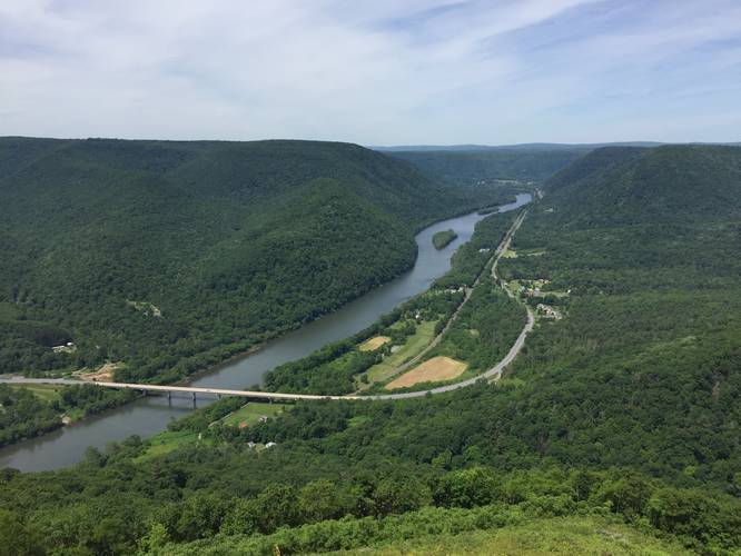
Lookout Point: Walk from the parking area over to the rock fence for a stunning view of the West Branch Susquehanna River and the valley below.

Pets: Dogs are allowed on leash and their waste must be carried out.

Hang gliding: There's a hang glider ramp just below the lookout point where hang gliders can take off and fly through the valley below. There's a page for hang gliding on the state park's website here; however, there are no notes about when hang gliding events take place. For information about Hyner View hang gliders, check out the HynerHang Gliding Club.
Explore 206 trails near North Bend, PA
  1. Parking

    41.326508, -77.623205
  2. Main Trailhead

    41.326464, -77.623384
  3. Vista point from Hyner View

    41.326514, -77.624519
    Vista point from Hyner View
No community routes found. To add your own hike as a Community Route for this Trail guide, leave a Trip Report with an attached GPX file.

Hazards

Ticks - Lyme Disease More Info (CDC)

Seasons

All

Trip Reports

Trail Guide By:
Admin user profile picture
0.2 miles / 0.3 km
0.2 miles / 0.3 km
June 08, 2019
Hiking

Weather Forecast

In North Bend, PA

Explore Hiking Trails

You May Also Like

Colorado's Million Dollar Highway - Plan a day's drive adventure along the iconic Million Dollar Highway in Colorado. Explore the best short trails, roadside stops, waterfalls, vistas, ghost towns, and hot springs within a ~6 hour road trip.
Explore

Colorado's Million Dollar Highway

Plan a day's drive adventure along the iconic Million Dollar Highway in Colorado. Explore the best short trails, roadside stops, waterfalls, vistas, ghost towns, and hot springs within a ~6 hour road trip.

Read
New York's Best Waterfalls - Whether you're planning a day hike, roadside stop, or a leisurely short walk, this guide provides hikers, travelers, and locals alike with 63 different locations to over 100 scenic waterfalls to help plan your next adventure!
Explore

New York's Best Waterfalls

Whether you're planning a day hike, roadside stop, or a leisurely short walk, this guide provides hikers, travelers, and locals alike with 63 different locations to over 100 scenic waterfalls to help plan your next adventure!

Read

Before you boogie...

Find our trail guides useful? Consider becoming a Supporter to unlock perks!

MyHikes is an indie platform that makes exploring public trails easier for everyone. The platform has no investors, no ads, and is owned and operated by one person, Dave Miller. Dave has personally mapped and written over 1,800 trail guides on MyHikes for the public to explore. MyHikes has helped millions outdoor enthusiasts plan their next adventure.

But it takes a lot of time 🕦, money 💰, work, and espresso shots ☕ to run MyHikes, including hiking , mapping , writing , and publishing new trails with high-quality (accurate) information... along with software engineering (coding) the platform like building new features, website and mobile app development (iOS and Android), site maintainance . and much much more.

Supporters unlock website and mobile app perks with an annual one-time payment of $25 (you renew) 😎👍. Or you can simply make a Donation of your choice. Otherwise, you can support us by telling your friends about MyHikes - both quick and free 🎉

Admin user profile picture

Dave Miller
MyHikes Founder