The Hyner View Hike at Bucktail State Park Natural Area in Hyner, Pennsylvania is a difficult 2.9-mile out-and-back hike that features a mountain ascent and stunning vistas from Hyner View.
Trails
This hike follows several named trails and roads in the following order: Huff Run Road, Cliffhanger Trail (yellow blazes), Carl's Way Trail (yellow blazes), Escarpment Trail (yellow blazes). The hike out follows the same list of trails in the opposite order.
Park Locations
Most of this hike exists within the Bucktail State Park Natural Area, but the last section of the hike leads into Hyner View State Park.
Hike Description
This hike begins along Huff Run Road at the parking coordinates provided and head south along Huff Run Road until they reach the end of the road where they'll find the trailhead for the Cliffhanger Trail - the real hike begins here. Interesting to note, as of May 2023, there's an old bus located off-trail next to the trailhead which is a neat forest find; however, that land is private property so please stay on-trail.
Carl's Way Trail / Left-Turn - Mile 0.25
Around mile 0.25, hikers will take a left-hand turn onto Carl's Way Trail. Carl's Way is more difficult hiking than the Cliffhanger Trail as it begins the ascent up the mountain. Most of Carl's Way is a moderate uphill climb with minimal undulation. Hikers will find lots of wildflowers along the trail during the Spring.
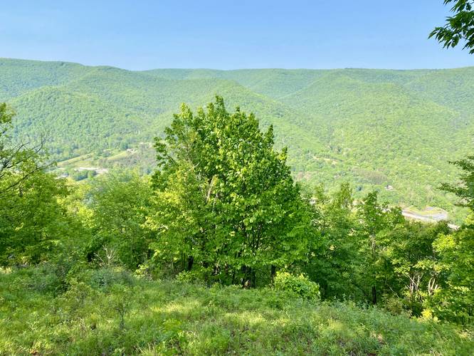
Obstructed View - Mile 0.77
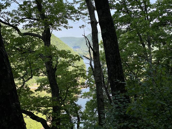
Around mile 0.77, along Carl's Way Trail, hikers will find an obstructed view of the West Branch Susquehanna River and the surrounding mountains, but is easy to miss.
Escarpment Trail / Left-Turn - Mile 0.85
At mile 0.85, hikers will take a left-hand turn onto the Escarpment Trail. Here the hike becomes a lot more difficult. The Escarpment Trail includes very few flat sections or "mountain benches" as the trail ascends the mountain and has the steepest elevation grade along the entire hike. Note that some sections of the Escarpment Trail are very steep especially mile 1.05 to 1.1.
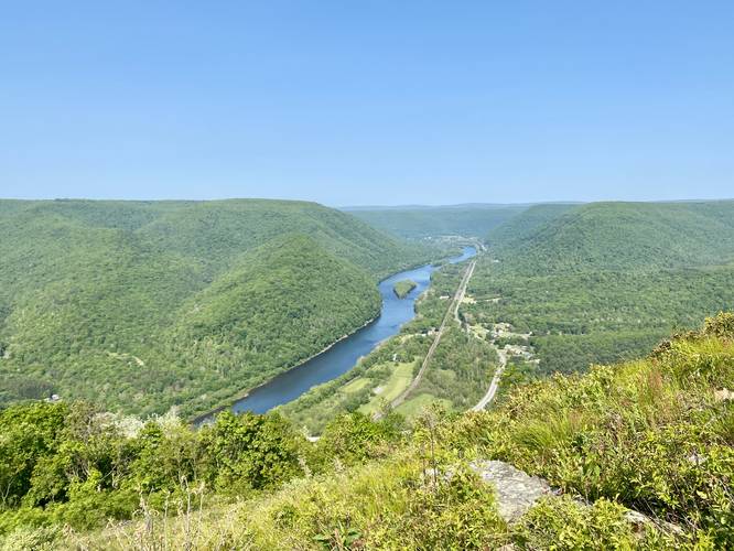
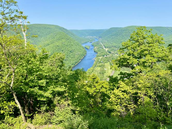
Mountain and River Views - Mile 1.1 to 1.15
Just after the steepest section in the Escarpment Trail, from mile 1.1 to 1.15, hikers will find a handful of different views from the trail. The best of which is at mile 1.15 which includes views of the West Branch Susquehanna River, Hyner, and the surrounding mountains.
Hyner View Opens - Mile 1.38 to 1.45
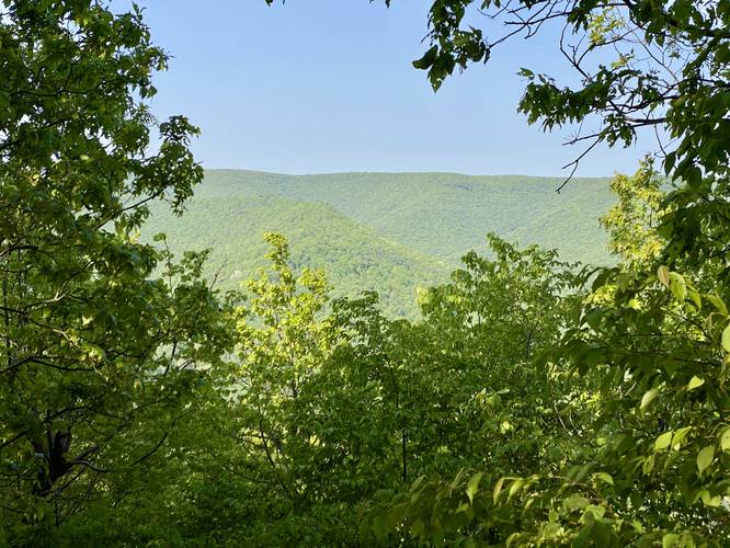
At mile 1.38, the forest finally opens to Hyner View's mountain top slopes where hikers will get 180-degree views of the mountains and gorge surrounding the West Branch Susquehanna River and Hyner, Pennsylvania as they ascend up to the very top of Hyner Mountain. This last section of the Escarpment Trail is steep as well, but the views and low-growing shrubs, plants, and wildflowers here tend to take your mind off of the climb.
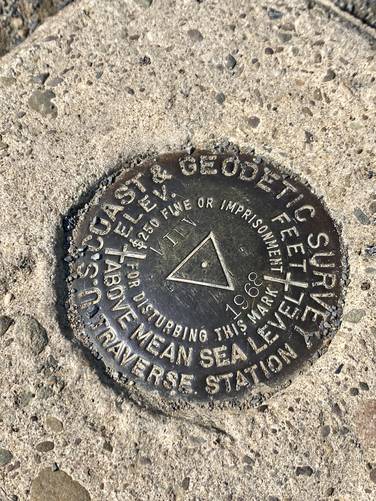
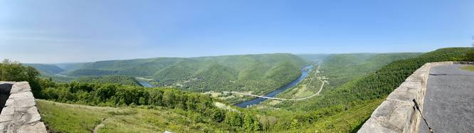
Hyner View, Summit Marker - Mile 1.45
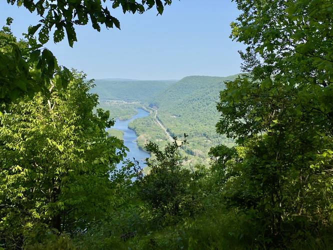
At mile 1.45, hikers will reach the top of Hyner Mountain's southern ridge which features the main overlook at Hyner View. The views from the overlook are identical to the views from the open mountain slopes, but at the top hikers can find a U.S. Coast & Geodetic Survey summit marker which is a neat find for peak baggers. From Hyner View's overlook, hikers can hang out to enjoy the stunning payout they climbed 1,300-feet to see.
Hiking Out
While identical but opposite to the hike up, the hike out is much easier than the ascent. Note that hikers should take it slow along the very steep section of the Escarpment Trail and watch out for loose rocks and leaves on their way down to avoid slipping and falling down the steep slopes of Hyner Mountain.
Parking
Hikers will find a large parking turnout at the coordinates provided along Huff Run Road, about half-way down the road. This parking turnout is located 0.13 miles from the trailhead.
Pets
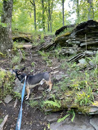
Dogs are allowed if leashed and must be cleaned up after.
Restrooms
There are outhouse restrooms provided by Hyner View State Park at the top of the mountain at Hyner View.
Warning
Steep terrain: Some of the terrain on this mountain is very steep with some loose rocks and often covered in leaves. Trekking poles and proper footwear help a lot.
Trails
This hike follows several named trails and roads in the following order: Huff Run Road, Cliffhanger Trail (yellow blazes), Carl's Way Trail (yellow blazes), Escarpment Trail (yellow blazes). The hike out follows the same list of trails in the opposite order.
Park Locations
Most of this hike exists within the Bucktail State Park Natural Area, but the last section of the hike leads into Hyner View State Park.
Hike Description
This hike begins along Huff Run Road at the parking coordinates provided and head south along Huff Run Road until they reach the end of the road where they'll find the trailhead for the Cliffhanger Trail - the real hike begins here. Interesting to note, as of May 2023, there's an old bus located off-trail next to the trailhead which is a neat forest find; however, that land is private property so please stay on-trail.
Carl's Way Trail / Left-Turn - Mile 0.25
Around mile 0.25, hikers will take a left-hand turn onto Carl's Way Trail. Carl's Way is more difficult hiking than the Cliffhanger Trail as it begins the ascent up the mountain. Most of Carl's Way is a moderate uphill climb with minimal undulation. Hikers will find lots of wildflowers along the trail during the Spring.
Obstructed View - Mile 0.77
Around mile 0.77, along Carl's Way Trail, hikers will find an obstructed view of the West Branch Susquehanna River and the surrounding mountains, but is easy to miss.
Escarpment Trail / Left-Turn - Mile 0.85
At mile 0.85, hikers will take a left-hand turn onto the Escarpment Trail. Here the hike becomes a lot more difficult. The Escarpment Trail includes very few flat sections or "mountain benches" as the trail ascends the mountain and has the steepest elevation grade along the entire hike. Note that some sections of the Escarpment Trail are very steep especially mile 1.05 to 1.1.
Mountain and River Views - Mile 1.1 to 1.15
Just after the steepest section in the Escarpment Trail, from mile 1.1 to 1.15, hikers will find a handful of different views from the trail. The best of which is at mile 1.15 which includes views of the West Branch Susquehanna River, Hyner, and the surrounding mountains.
Hyner View Opens - Mile 1.38 to 1.45
At mile 1.38, the forest finally opens to Hyner View's mountain top slopes where hikers will get 180-degree views of the mountains and gorge surrounding the West Branch Susquehanna River and Hyner, Pennsylvania as they ascend up to the very top of Hyner Mountain. This last section of the Escarpment Trail is steep as well, but the views and low-growing shrubs, plants, and wildflowers here tend to take your mind off of the climb.
Hyner View, Summit Marker - Mile 1.45
At mile 1.45, hikers will reach the top of Hyner Mountain's southern ridge which features the main overlook at Hyner View. The views from the overlook are identical to the views from the open mountain slopes, but at the top hikers can find a U.S. Coast & Geodetic Survey summit marker which is a neat find for peak baggers. From Hyner View's overlook, hikers can hang out to enjoy the stunning payout they climbed 1,300-feet to see.
Hiking Out
While identical but opposite to the hike up, the hike out is much easier than the ascent. Note that hikers should take it slow along the very steep section of the Escarpment Trail and watch out for loose rocks and leaves on their way down to avoid slipping and falling down the steep slopes of Hyner Mountain.
Parking
Hikers will find a large parking turnout at the coordinates provided along Huff Run Road, about half-way down the road. This parking turnout is located 0.13 miles from the trailhead.
Pets
Dogs are allowed if leashed and must be cleaned up after.
Restrooms
There are outhouse restrooms provided by Hyner View State Park at the top of the mountain at Hyner View.
Warning
Steep terrain: Some of the terrain on this mountain is very steep with some loose rocks and often covered in leaves. Trekking poles and proper footwear help a lot.