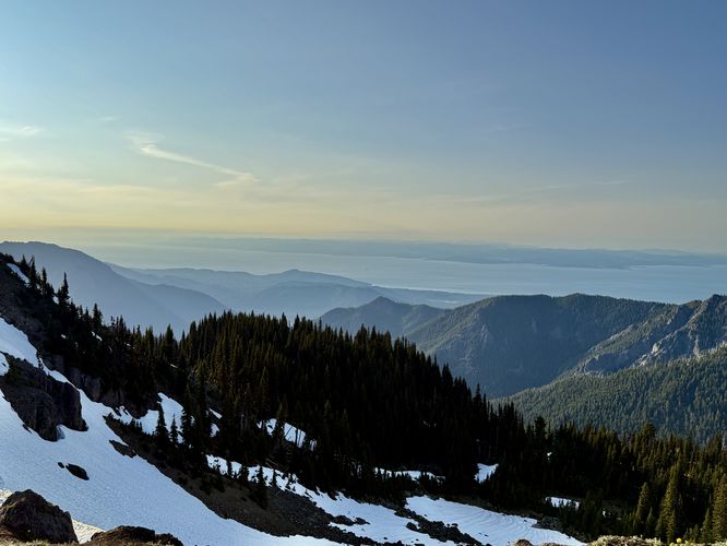
The Hurricane Hill Trail at Olympic National Park near Port Angeles, Washington is a difficult 3.4-mile out-and-back hike that features panoramic views of snow and glacier-capped mountains, Port Angeles, and even Vancouver Island in Canada from Hurricane Ridge.
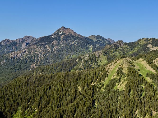
The paved trail follows a mostly-flat elevation grade, with minimal easy uphill portions for the first half-mile of the hike. On your way toward the steeper section of trail, you'll also find views to the east. Eastward views include Mount Angeles and its surrounding peaks like First Top and Second Top. Around mile 0.5, hikers will pass the Little River Trail on the right-hand side, which is where the Hurricane Hill Trail begins to climb at a moderate to "hard" elevation grade.
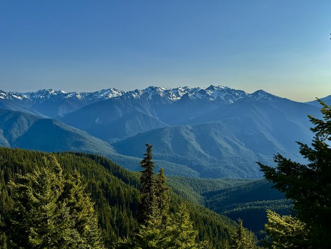
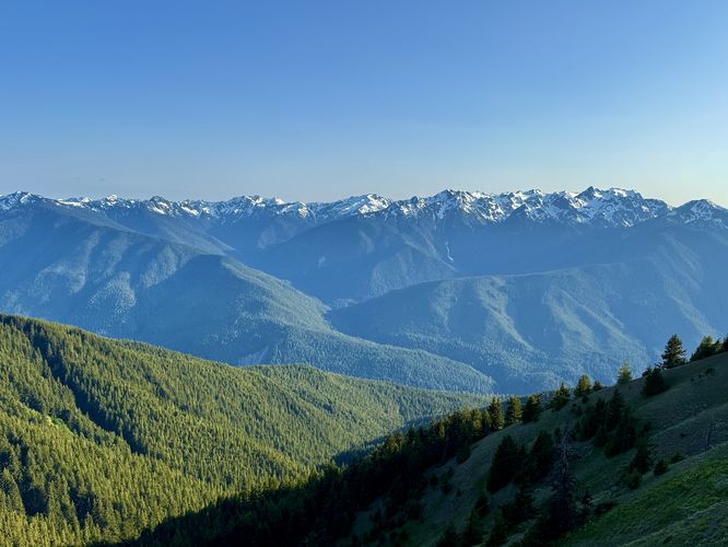
On your way toward the summit of Hurricane Hill, the trail continues to provide stunning panoramic views of the Olympic Mountains, wildflowers growing on the trail, and opportunities to keep an eye out for wildlife like the Olympic Marmot and deer.
Cougars: This area is habitat for the cougar / mountain lion. While rare, they can pass through from time to time. It's best to hike in a group of 2 or more and keep small children close at all times. Be aware of your surroundings and make noise while hiking to alert cougars of your presence.
Hiking Hurricane Ridge
This hike begins at the main parking lot at the end of Hurricane Ridge Road where visitors will find the trailhead on the northwest side of the lot. The Hurricane Hill Trail first passes through an evergreen forest before it quickly opens up to stunning panoramic views of the Olympic Mountains with their snow and glacier-capped peaks in the distance.The paved trail follows a mostly-flat elevation grade, with minimal easy uphill portions for the first half-mile of the hike. On your way toward the steeper section of trail, you'll also find views to the east. Eastward views include Mount Angeles and its surrounding peaks like First Top and Second Top. Around mile 0.5, hikers will pass the Little River Trail on the right-hand side, which is where the Hurricane Hill Trail begins to climb at a moderate to "hard" elevation grade.
On your way toward the summit of Hurricane Hill, the trail continues to provide stunning panoramic views of the Olympic Mountains, wildflowers growing on the trail, and opportunities to keep an eye out for wildlife like the Olympic Marmot and deer.
Hurricane Hill's Switchbacks - Mile 1.2
After passing some difficult uphill section of trail, the Hurricane Hill Trail finally starts to follow switchbacks as it leads toward its summit. These switchbacks begin at mile 1.2 and are arguably not easy. Despite the paved surface and less-steep elevation grade of the switchbacks, you'll likely need to take breaks as you push the last 0.44 miles to reach the summit.Hurricane Hill's Summit - Mile 1.64
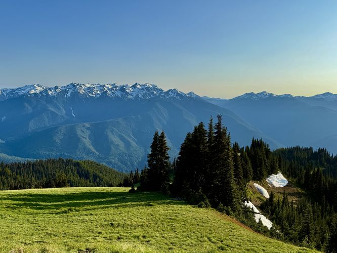
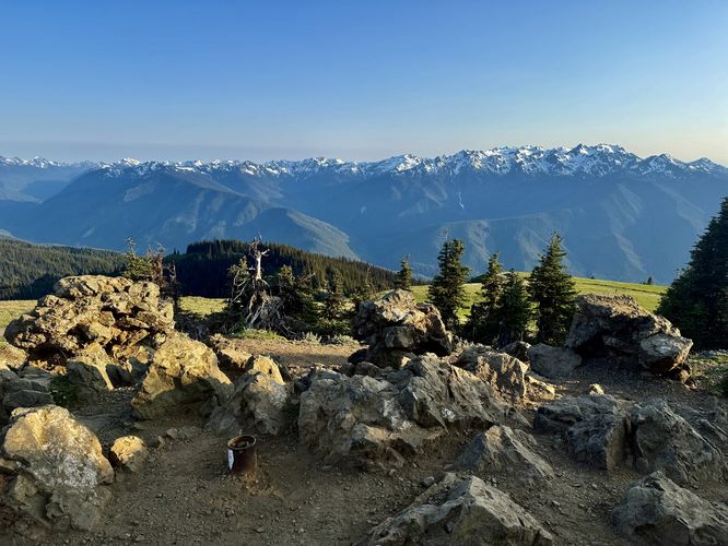
Once the switchback end, you'll find yourself just below the summit of Hurricane Hill where the pavement ends and the dirt begins. Most hikers will take a right-hand turn to head toward an information kiosk with panoramic views; however, when summitting a mountain, I like to truly summit it, so this route leads directly to the summit of Hurricane Hill. Taking a left-hand turn and following the dirt path up to the summit of Hurricane Hill provides hikers with more panoramic views, but this time they're in all directions. From here, you'll find views of Unicorn Peak, Unicorn Horn, Griff Peak, downtown Port Angeles, Vancouver Island, Mount Angeles, and of course, the Olympic Mountains. One neat find at the summit are old concrete footings and stonewall corner structures that are still standing. These old remnants are leftover from some type of structure that used to sit here. Personally I'm unsure what structure stood here, maybe it was a fire lookout tower, backpacking shelter, or something else but the old remnants were an unexpected find for us.Hurricane Hill's Eastern View - Mile 1.74
After exploring the summit, you'll want to check out the eastern slopes of Hurricane Hill before you hike down. This route leads along the mountain's ridge to reach the eastern viewpoint where you'll find an information kiosk labeling the Olympic Mountain range. During our hike here in the evening, we found dozens of deer on the slopes of the mountain looking for their dinner with the backdrop of the snow-capped Olympic Mountains.Hiking Out - Mile 1.74 to 3.4
After enjoying the panoramic views of the Olympic Mountains from the top of Hurricane Hill, eventually you'll want to head back to parking. The hike down is straight forward, just follow the paved path back to your vehicle, but be on the lookout for animals along the way. During our sunset hike here, we found Olympic Marmots and dozens of deer on the hillside. Follow the paved path down the switchbacks, pass more panoramic views, and wrap it up at the parking lot for a stunning 3.4-mile out-and-back hike.Difficulty
Note that the entire trail should not be considered "hard" difficulty, but the first 0.5 miles of the paved path are in fact relatively easy. The trail's elevation grade becomes even harder as it approaches the summit of Hurricane Hill and panoramic views can be found from nearly the start of the hike, so you don't need to go very far to enjoy stunning scenery along this paved path. Some advanced hikers or runners may find this hike to be moderate.Universal Accessibility
The Hurricane Hill Trail follows a smooth, paved path and should be considered universally-accessible for 90% of its length. Just below the summit of Hurricane Hill, the trail switches from paved to dirt, so the summit itself may not be fully accessible. The eastern view below the summit follows a dirt path and may be accessible for most visitors.Wildlife Viewing
This is a great trail for viewing wildlife, especially Olympic Marmots and deer. Show up during the early morning or late evening to increase your chances of seeing some of Olympic National Park's wildlife on trail trail.Other Hikes on Hurricane Ridge
After you hike to the summit of Hurricane Hill and back, consider hiking out to Sunrise Point, which is located on Hurricane Ridge just east of this trail. The Sunrise Point Loop is a short and moderate 0.9-mile hike leads to breathtaking panoramic easterly views that, obviously, can be appreciated best at sunrise. The best part are the additional southern and western views too, so not only can you watch the sunrise along the Sunrise Point Loop, you can even watch the sunset from it too. If you show up in June or July, the sun will set directly over Hurricane Hill, so if you time your day right you can hike the summit of Hurricane Hill, then watch the sun set atop of it like we did.Warning
Steep terrain: The Hurricane Hill Trail runs along some extremely-steep mountain slopes. For folks who are not used to this, it may take some time for your brain to "normalize" to the heights and steepness. If you stay on-trail at all times, you will be fine. The trail is paved and wide enough to safely traverse this terrain. Note that the trail's elevation grade becomes steeper as you ascend toward the summit.Cougars: This area is habitat for the cougar / mountain lion. While rare, they can pass through from time to time. It's best to hike in a group of 2 or more and keep small children close at all times. Be aware of your surroundings and make noise while hiking to alert cougars of your presence.