Loading...

Distance:
4.2 Miles / 6.8 km
Type:
One-Way
Difficulty:
Moderate
Time to Hike:
2 hours, ~6 minutes
Features:
Surface Type:
Dirt
Park:
King Range National Conservation Area
Town:
Whitethorn, California
Directions:
40.094547, -124.063407
Added:
June 15, 2019
Updated:
February 22, 2024
Loading...
Loading...
1,520 '

Total Change
140 '

Ascent
1,655 '

Descent

The Horse Mountain Creek Trail at King Range National Conservation Area in Whitehorn, California is a moderate 4.2-mile one-way trail that leads along the mountain ridges above Horse Mountain Creek and out to the California coast.

Elevation Loss / Gain: The trail heads down approximately 1,500-feet to the beach. If you plan to hike this trail out-and-back from 8.4-miles, be prepared to lose and gain a little bit over 1,500-feet for the entire hike.

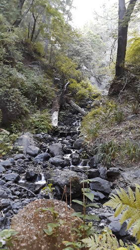
Waterfalls: Waterfalls can be found cascading down the mountainside along the trail. If you carry a water filter, you can also filter the creek water to refill.

Parking: Parking can be found at the coordinates provided along King Peak Road.

Pets: Dogs are allowed on this trail and their waste must be carried out.

Water source: Along the trail are creeks that spill down the mountainside, which you can use for refilling your water bottle, if you use a water filter.

Explore 1 trail near Whitethorn, CA
  1. Parking

    40.094547, -124.063407
  2. Main Trailhead

    40.09453, -124.063214
  3. Waterfall

    40.081389, -124.076667
    Waterfall
No community routes found. To add your own hike as a Community Route for this Trail guide, leave a Trip Report with an attached GPX file.

Hazards

Ticks - Lyme Disease More Info (CDC)
Snakes
Poison Ivy/Oak

Seasons

All

Photo Albums

1 Trip Report

No Star-Ratings
Trail Guide By:
VanDemanJr user profile picture
4.2 miles / 6.8 km
Trail added
June 15, 2019
Hiked on
June 12, 2019
Updated on
February 22, 2024

Weather Forecast

In Whitethorn, CA

Explore Hiking Trails

New Hikes

Sheep Lakes Lookout
0.1 Miles
0.2 km
Easy
Out-and-Back
Boulder Falls Trail
0.2 Miles
0.3 km
Moderate
Out-and-Back
Fish Dam Run Vista
0.2 Miles
0.3 km
Easy
Out-and-Back
Alluvial Fan (East) Waterfall
0.4 Miles
0.6 km
Easy
Out-and-Back

Before you boogie...

Find our trail guides useful? Consider becoming a Supporter to unlock perks!

MyHikes is an indie platform that makes exploring public trails easier for everyone. The platform has no investors, runs no ads, and is owned and operated by one person, Dave Miller. Dave has personally mapped and written over 1,600 trail guides on MyHikes for the public to explore. As of 2024, MyHikes has helped over 1,300,000 outdoor enthusiasts plan their next adventure.

But it takes a lot of time 🕦, money 💰, and work, and espresso shots ☕ to run MyHikes, including hiking , mapping , writing , and publishing new trails with high-quality (accurate) information... along with software engineering (coding) the platform like building new features, site and mobile app development for iOS and Android, site maintainance . and much much more.

Supporters unlock website and mobile app perks with an annual one-time payment of $25 (you renew) 😎👍. Or you can simply make a Donation of your choice. Otherwise, you can support us by telling your friends about MyHikes - both quick and free 🎉

Admin user profile picture

Dave Miller
MyHikes Founder