Loading...

🍁 Fall is here! Check out our foliage map to plan your autumn hikes! Learn more.

Hone Quarry Ridge Hike

Directions
Map
Pictures
Send to App
Distance:
5.3 Miles / 8.5 km
Type:
Loop
Difficulty:
Moderate
Time to Hike:
2 hours, ~39 minutes
Features:
Surface Type:
Dirt
Park:
George Washington National Forest
Town:
Bridgewater, Virginia
Get Directions:
38.462277, -79.133921
Added:
January 27, 2025
Updated:
April 04, 2025
Guide by:
Copy Trail Link Hiking this trail? Send a friend or family member a link to this trail guide for your own safety. Hike at your own risk (disclaimer)
Loading...
Loading...
1,259'

Total Change
1,579'

Ascent
1,582'

Descent

Download the Trail Route for Offline Use

Supporters get exclusive access to download trail routes to the MyHikes app for offline use. Stay prepared on your adventure, even without an internet connection! Become a Supporter today to unlock this feature and hike with confidence.

Send to App

Key Takeaways

  • The Hone Quarry Ridge hike is a 5.3-mile loop trail near Bridgewater, VA, offering a vista at the Abbie Point overlook.
  • The hike involves a combination of trails (Big Hollow, Hone Quarry Mountain, Heartbreak) and an abandoned fire road, with varying levels of steepness.
  • The loop begins and ends near the Hone Quarry Campground, making it convenient for campers.

Hone Quarry Ridge Hike

The Hone Quarry area is nestled in a quiet area of the GWNF just west of Harrisonburg VA. With two beautiful loop hikes, one up Oak Knob and Pond Knob with two overlooks, and the other on the opposite Hone Quarry Ridge also with a beautiful vista at the Abbie Point overlook. The valley also has great camping at the Hone Quarry Campground (vid).

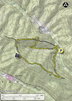
Turn left out of the Hone Quarry Campground on Hone Quarry Rd/FR62 and shortly cross Hone Quarry Run over a spillway. In 200 yards turn left on the yellow blazed Big Hollow/430 trail. In 0.1 miles arrive at the intersection of the Heartbreak/435A trail.

Stay right on the Big Hollow trail as it starts ascending the mountain next to a stream for 0.8 miles before making a switchback to the right. In another 0.3 miles the trail will cross an abandoned fire road, then pass back around a spur before heading uphill and joining the abandoned fire road in another 0.4 miles.

The Big Hollow trail becomes wider where it joins the abandoned fire road, and also steeper without any switchbacks for the remaining 0.7 miles to the ridge, and intersection of the Hone Quarry Mountain/435 trail.

Turn left on the yellow blazed Hone Quarry Mountain trail, immediately passing a campsite, then descending through a saddle and climbing steeply to the best vista on the hike at the Abbie Point overlook in 0.6 miles.

From the overlook continue on the trail as it passes through another saddle, climbs the next knob, again passing through a saddle then arriving at the intersection of the Heartbreak/435A trail. The Hone Quarry Mountain trail is closed from this point.

Turn left on the yellow blazed Heartbreak trail as it begins to descend the mountain. Pass several rock slides before the trail begins to level out reaching Hone Quarry Run and the Hone Quarry Run Campground on the opposite bank in 1.0 miles.

The Hone Quarry Run trail will continue for another 0.1 miles back to the intersection Big Hollow trail. Stay right on the Big Hollow trail for 0.1 miles to return to Hone Quarry Rd/FR62.

Stay right on Hone Quarry Rd/FR62 for the remaining 300 yards to the Hone Quarry Campground.

Explore 46 trails near Bridgewater, VA
  1. Parking

    38.462277, -79.133921
  2. Main Trailhead

    38.463233, -79.134908
No community routes found. To add your own hike as a Community Route for this Trail guide, leave a Trip Report with an attached GPX file.

Hazards

Ticks - Lyme Disease More Info (CDC)
Snakes
Poison Ivy/Oak

Seasons

All

Blaze Color

Yellow

Photo Albums

+ Add Photo Album

Upload your photos from the trail to help others know what to expect.

Preview of the MyHikes mobile app interface

Track, Log, and Explore Hikes with the MyHikes App

Explore Autumn Foliage

No Change
Some Color
Low Color
Moderate Color
High Color
Peak Color
Past Peak
Sept 1 Sept 8 Sept 15 Sept 22 Sept 29 Oct 6 Oct 13 Oct 20 Oct 27 Nov 3 Nov 10 Nov 17 Nov 24

Trip Reports (Reviews)

Ready to help fellow hikers? Add a trip report to share your experience and provide valuable insights for those planning their next hike. Your review makes the trail better for everyone.

Rated 3.05 out of 5 based on 20 ratings.
By: Jeff Monroe
5.3 miles / 8.5 km
November 05, 2019
I didn't have great expectations for this hike given the rash of recent 1 star reviews, but I had some time before meeting my son at JMU for lunch and I'd never hiked most of this loop. I was pleasantly surprised and really enjoyed the hike. The problem is that the Forest Service has done several prescribed burns in this area, and it resulted in a mess of down trees and briars. The PATC's Southern Shenandoah Valley Chapter complained (they signed on in 2019 to maintain this and other nearby trails), and a USFS fire crew went up there with weed eaters and chainsaws. It still isn't perfect (they didn't finish the job), and the time of year may have also had something to do with it (early November), but I observed only a handful of issues - almost all on the ascent on the Big Hollow Trail. It was worth the trouble because the vistas at the top were wonderful! And it was a great workout. If you go, help the trail club out by moving branches off of the trail. This loop is going to be a lot of work to maintain!
Legacy Review
By: Sarah
5.3 miles / 8.5 km
June 25, 2019
Hiked the loop clockwise yesterday (without reading reviews first unfortunately) and the overgrowth is so bad at this point that I could not find the downward trail to return to my car. Brush was taller than me at times. Given the late evening time, I had to hike onto the fire road along the ridge and get picked up off Brandywine near WVa.
Legacy Review
By: Justin
5.3 miles / 8.5 km
June 01, 2019
Mike B's review from 27 May about sums it up. The trail is very overgrown right now. The lower portion (first mile and a half if hiking the loop CCW) is nice, but once you gain some altitude, the grass is knee height. Thorns and plants almost block the path. I pulled 8 ticks off myself and many off my kids. I would avoid in late spring and summer.
Legacy Review

Weather Forecast

In Bridgewater, VA

Explore Hiking Trails

You May Also Like

New York's Best Waterfalls - Whether you're planning a day hike, roadside stop, or a leisurely short walk, this guide provides hikers, travelers, and locals alike with 63 different locations to over 100 scenic waterfalls to help plan your next adventure!
Explore

New York's Best Waterfalls

Whether you're planning a day hike, roadside stop, or a leisurely short walk, this guide provides hikers, travelers, and locals alike with 63 different locations to over 100 scenic waterfalls to help plan your next adventure!

Read
25 Best Day Hikes in North Carolina - Discover the top 25 best day hikes in North Carolina, from breathtaking waterfalls to mountain peaks. Explore hidden gems, scenic views, and trails suitable for all skill levels, perfect for your next outdoor adventure.
Explore

25 Best Day Hikes in North Carolina

Discover the top 25 best day hikes in North Carolina, from breathtaking waterfalls to mountain peaks. Explore hidden gems, scenic views, and trails suitable for all skill levels, perfect for your next outdoor adventure.

Read

Before you boogie...

Find our trail guides useful? Consider becoming a Supporter to unlock perks!

MyHikes is an indie platform that makes exploring public trails easier for everyone. The platform has no investors, no ads, and is owned and operated by one person, Dave Miller. Dave has personally mapped and written over 1,800 trail guides on MyHikes for the public to explore. MyHikes has helped millions outdoor enthusiasts plan their next adventure.

But it takes a lot of time 🕦, money 💰, work, and espresso shots ☕ to run MyHikes, including hiking , mapping , writing , and publishing new trails with high-quality (accurate) information... along with software engineering (coding) the platform like building new features, website and mobile app development (iOS and Android), site maintainance . and much much more.

Supporters unlock website and mobile app perks with an annual one-time payment of $25 (you renew) 😎👍. Or you can simply make a Donation of your choice. Otherwise, you can support us by telling your friends about MyHikes - both quick and free 🎉

Admin user profile picture

Dave Miller
MyHikes Founder