Loading...

๐ŸŽ‰ Enjoy a Free 7-Day Supporter Trial and Unlock Exclusive Perks โ€” No Credit Card Required. Learn more.

Hog Island (Patriots Point) Trail

Directions
Map
Pictures
Send to App
Distance:
0.3 Miles / 0.5 km
Type:
Out-and-Back
Difficulty:
Easy
Time to Hike:
~9 minutes
Features:
Surface Type:
Dirt
Town:
Mount Pleasant, South Carolina
Directions:
32.788017, -79.900565
Added:
March 03, 2024
Updated:
May 03, 2024
Copy Trail Link Hiking this trail? Send a friend or family member a link to this trail guide for your own safety. Hike at your own risk (disclaimer)
Loading...
Loading...
9'

Total Change
12'

Ascent
12'

Descent

Download the Trail Route for Offline Use

Supporters get exclusive access to download trail routes to the MyHikes app for offline use. Stay prepared on your adventure, even without an internet connection! Become a Supporter today to unlock this feature and hike with confidence.

Send to App

Hog Island (Patriots Point) Trail

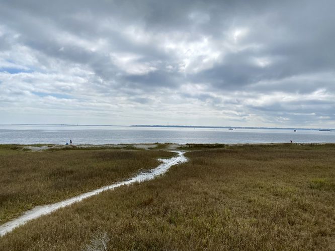
The Hog Island (Patriot's Point) Trail in Mount Pleasant, South Carolina is an easy 0.3-mile out-and-back trail that features an observation deck with views of Charleston and the bay.

This is very short trail leads from the Patriots Point Links golf course (which provides public parking), following a defined path and out to the shoreline. The trailhead can be found west of the parking area and is best found by locating the silver historical "Hog Island" sign. The trail heads into the forest, passing palmetto, wild Carolina Jasmine, and other low-growing bushes before reaching an observation deck at the end of the trail. Here, you can climb the short staircase of the observation deck to get a better view of the area. The view from the top is mostly the shoreline and bay ahead of you, but to the right-hand side (west) you'll find views of Charleston, mainly around the French Quarter. After visiting the views, the walk back is short and leads back to parking for a 0.3-mile out-and-back jaunt.

Parking
Walkers will find a large parking lot at the coordinates provided, located at the end of Club House Road in Mount Pleasant, SC. The lot is large enough to fit many dozens of vehicles. Parking for the trailhead is easiest if you park on the west side of the lot.

Pets
Dogs are allowed only if leashed and must be cleaned up after.
Explore 5 trails near Mount Pleasant, SC
  1. Parking

    32.788017, -79.900565
  2. Main Trailhead

    32.787604, -79.900984
  3. View from the Hog Island Observation Deck

    32.786583, -79.899689
    View from the Hog Island Observation Deck
No community routes found. To add your own hike as a Community Route for this Trail guide, leave a Trip Report with an attached GPX file.

Hazards

Snakes

Seasons

All

Trip Reports

Trail Guide By:
Admin user profile picture
0.3 miles / 0.5 km
0.3 miles / 0.5 km
March 03, 2024
Hiking

Weather Forecast

In Mount Pleasant, SC

Explore Hiking Trails

You May Also Like

Colorado's Million Dollar Highway - Plan a day's drive adventure along the iconic Million Dollar Highway in Colorado. Explore the best short trails, roadside stops, waterfalls, vistas, ghost towns, and hot springs within a ~6 hour road trip.
Explore

Colorado's Million Dollar Highway

Plan a day's drive adventure along the iconic Million Dollar Highway in Colorado. Explore the best short trails, roadside stops, waterfalls, vistas, ghost towns, and hot springs within a ~6 hour road trip.

Read
Glacier's Going-to-the-Sun Road - Discover the breathtaking beauty of Glacier National Park along the iconic Going-to-the-Sun Road. From stunning roadside stops to picturesque waterfalls and vistas, this engineering marvel offers endless opportunities for exploration.
Explore

Glacier's Going-to-the-Sun Road

Discover the breathtaking beauty of Glacier National Park along the iconic Going-to-the-Sun Road. From stunning roadside stops to picturesque waterfalls and vistas, this engineering marvel offers endless opportunities for exploration.

Read
New York's Best Waterfalls - Whether you're planning a day hike, roadside stop, or a leisurely short walk, this guide provides hikers, travelers, and locals alike with 63 different locations to over 100 scenic waterfalls to help plan your next adventure!
Explore

New York's Best Waterfalls

Whether you're planning a day hike, roadside stop, or a leisurely short walk, this guide provides hikers, travelers, and locals alike with 63 different locations to over 100 scenic waterfalls to help plan your next adventure!

Read

Before you boogie...

Find our trail guides useful? Consider becoming a Supporter to unlock perks!

MyHikes is an indie platform that makes exploring public trails easier for everyone. The platform has no investors, no ads, and is owned and operated by one person, Dave Miller. Dave has personally mapped and written over 1,800 trail guides on MyHikes for the public to explore. MyHikes has helped millions outdoor enthusiasts plan their next adventure.

But it takes a lot of time ๐Ÿ•ฆ, money ๐Ÿ’ฐ, work, and espresso shots โ˜• to run MyHikes, including hiking , mapping , writing , and publishing new trails with high-quality (accurate) information... along with software engineering (coding) the platform like building new features, website and mobile app development (iOS and Android), site maintainance . and much much more.

Supporters unlock website and mobile app perks with an annual one-time payment of $25 (you renew) ๐Ÿ˜Ž๐Ÿ‘. Or you can simply make a Donation of your choice. Otherwise, you can support us by telling your friends about MyHikes - both quick and free ๐ŸŽ‰

Admin user profile picture

Dave Miller
MyHikes Founder