Loading...

🎉 Enjoy a Free 7-Day Supporter Trial and Unlock Exclusive Perks — No Credit Card Required. Learn more.

Hofma Preserve North Loop

Directions
Map
Pictures
Send to App
Distance:
0.5 Miles / 0.8 km
Type:
Loop
Difficulty:
Easy
Time to Hike:
~15 minutes
Features:
Surface Type:
Dirt
Park:
Hofma Preserve
Town:
Grand Haven, Michigan
Directions:
43.023742, -86.191845
Added:
January 16, 2020
Updated:
February 04, 2020
Copy Trail Link Hiking this trail? Send a friend or family member a link to this trail guide for your own safety. Hike at your own risk (disclaimer)
Loading...
Loading...
34'

Total Change
27'

Ascent
33'

Descent

Download the Trail Route for Offline Use

Supporters get exclusive access to download trail routes to the MyHikes app for offline use. Stay prepared on your adventure, even without an internet connection! Become a Supporter today to unlock this feature and hike with confidence.

Send to App

Hofma Preserve North Loop

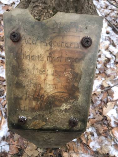
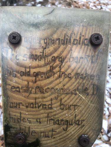
The Hofma Preserve North Loop at Hofma Preserve in Grand Haven, Michigan is an easy 0.5-mile loop trail that features a peaceful walk through the woods.

This loop trail encompasses the northern section of Hofma Preserve which runs through the forest just south of a tributary that feeds the Pottawattomie Bayou. While this trail does not run very close to Pottawattomie Bayou or the creek that runs into the bayou, the Hofma Preserve land does run almost all the way to the water.

The trailhead can be found on both the north and east side of the parking lot - giving hikers the option to choose which way they want to hike this trail. The GPS track provided is a clockwise recording starting at the northern trailhead and ending at the eastern trailhead at the parking lot.

Pets

Dogs are allowed if leashed and their waste must be carried out by the hiker.

Parking
Hikers can find parking at the coordinates provided. The parking lot is small and only holds about a half-dozen vehicles. The parking area also has restrooms, picnic tables, and a playground.
Explore 16 trails near Grand Haven, MI
  1. Parking

    43.023742, -86.191845
  2. Main Trailhead

    43.023913, -86.192218
  3. Interpretive sign

    43.023128, -86.190608
    Interpretive sign
  4. Interpretive sign

    43.023078, -86.190731
    Interpretive sign
No community routes found. To add your own hike as a Community Route for this Trail guide, leave a Trip Report with an attached GPX file.

Hazards

Ticks - Lyme Disease More Info (CDC)

Seasons

All

Photo Albums

Trip Reports

Trail Guide By:
swaevior user profile picture
0.5 miles / 0.8 km

Weather Forecast

In Grand Haven, MI

Explore Hiking Trails

You May Also Like

Colorado's Million Dollar Highway - Plan a day's drive adventure along the iconic Million Dollar Highway in Colorado. Explore the best short trails, roadside stops, waterfalls, vistas, ghost towns, and hot springs within a ~6 hour road trip.
Explore

Colorado's Million Dollar Highway

Plan a day's drive adventure along the iconic Million Dollar Highway in Colorado. Explore the best short trails, roadside stops, waterfalls, vistas, ghost towns, and hot springs within a ~6 hour road trip.

Read
Glacier's Going-to-the-Sun Road - Discover the breathtaking beauty of Glacier National Park along the iconic Going-to-the-Sun Road. From stunning roadside stops to picturesque waterfalls and vistas, this engineering marvel offers endless opportunities for exploration.
Explore

Glacier's Going-to-the-Sun Road

Discover the breathtaking beauty of Glacier National Park along the iconic Going-to-the-Sun Road. From stunning roadside stops to picturesque waterfalls and vistas, this engineering marvel offers endless opportunities for exploration.

Read
New York's Best Waterfalls - Whether you're planning a day hike, roadside stop, or a leisurely short walk, this guide provides hikers, travelers, and locals alike with 63 different locations to over 100 scenic waterfalls to help plan your next adventure!
Explore

New York's Best Waterfalls

Whether you're planning a day hike, roadside stop, or a leisurely short walk, this guide provides hikers, travelers, and locals alike with 63 different locations to over 100 scenic waterfalls to help plan your next adventure!

Read

Before you boogie...

Find our trail guides useful? Consider becoming a Supporter to unlock perks!

MyHikes is an indie platform that makes exploring public trails easier for everyone. The platform has no investors, no ads, and is owned and operated by one person, Dave Miller. Dave has personally mapped and written over 1,800 trail guides on MyHikes for the public to explore. MyHikes has helped millions outdoor enthusiasts plan their next adventure.

But it takes a lot of time 🕦, money 💰, work, and espresso shots ☕ to run MyHikes, including hiking , mapping , writing , and publishing new trails with high-quality (accurate) information... along with software engineering (coding) the platform like building new features, website and mobile app development (iOS and Android), site maintainance . and much much more.

Supporters unlock website and mobile app perks with an annual one-time payment of $25 (you renew) 😎👍. Or you can simply make a Donation of your choice. Otherwise, you can support us by telling your friends about MyHikes - both quick and free 🎉

Admin user profile picture

Dave Miller
MyHikes Founder