The Hobble Falls & Hemlock Falls hike at South Mountain Reservation near Maplewood, New Jersey is a moderate 0.6-mile out-and-back hike that features two waterfalls -- Hobble Falls (~20-feet) and Hemlock Falls (~30-feet).
Hike Description
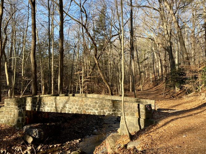
This hike begins at the main parking lot for Hemlock Falls, at the coordinates provided off of S Orange Ave. Note that this parking lot is accessible if headed east-bound on S Orange Ave only. The trailhead that this GPS track follows is located on the southeast side of the parking lot -- not the main trailhead (gate/fence) at the end of the parking lot. The trail has no signage and heads into the woods along a discrete path that often is a bit muddy -- however, this is a shortcut to reach the waterfalls so it has its trade-offs. The trail meanders through the woods, follow no blazes, until it reaches a very-steep downhill section. This downhill is by far the most-difficult part of the hike (hence the moderate difficulty) to reach the wider main trail located at the bottom of the hill. Once at the bottom of the hill, hikers will take a left-hand turn to hike to Hobble Falls. Hikers will pass one stone footbridge on their way to Hobble Falls before reaching the first downstream view of the cascade.
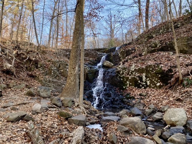
Hobble Falls - Mile 0.2
Around mile 0.2, hikers will reach the base of Hobble Falls. Hobble Falls is approximately 20-feet tall and cascades over the bedrock cliffs that make-up this part of South Mountain. Hobble Falls is a beautiful waterfall, but is not the last waterfall to explore on this hike. After taking in the scenery of Hobble Falls, hikers will head down the trail just a bit further to reach Hemlock Falls.
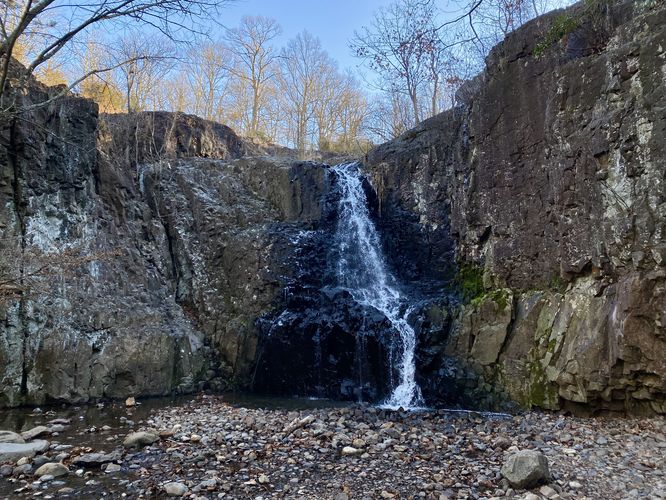
Hemlock Falls - Mile 0.3
At mile 0.3, hikers will have crossed a scenic stone footbridge to reach the base of Hemlock Falls. Hemlock Falls is approximately 30-feet tall and cascades over the same bedrock cliff that Hobble Falls spills over. Hemlock Falls, however, is more open with no obstructions in the view. The base of the waterfall has a shallow pool before the creek carries the water away downstream, passing under the stone footbridge you hiked over. Hemlock Falls has several benches around this natural rock amphitheater, so hang out and enjoy the scenery for as long as you wish.
Hiking Out
The hike out follows the same path as it did coming in. The only thing to note is that the steep uphill section can be a bit tricky to find due to the lack of signage, blazes, and foot traffic on that trail. If you miss the turn, your hike will ultimately be easier, but a bit longer to reach parking.
Parking
Hikers will find a small parking lot at the coordinates provided, located on the south side of S Orange Ave. Note that the only way to enter this parking lot is by traveling eastbound on S Orange Ave. The lot, as of December 2023, is large enough to fit less than 1 dozen vehicles.
Pets
Dogs are allowed only if leashed and must be cleaned up after.
Hike Description
This hike begins at the main parking lot for Hemlock Falls, at the coordinates provided off of S Orange Ave. Note that this parking lot is accessible if headed east-bound on S Orange Ave only. The trailhead that this GPS track follows is located on the southeast side of the parking lot -- not the main trailhead (gate/fence) at the end of the parking lot. The trail has no signage and heads into the woods along a discrete path that often is a bit muddy -- however, this is a shortcut to reach the waterfalls so it has its trade-offs. The trail meanders through the woods, follow no blazes, until it reaches a very-steep downhill section. This downhill is by far the most-difficult part of the hike (hence the moderate difficulty) to reach the wider main trail located at the bottom of the hill. Once at the bottom of the hill, hikers will take a left-hand turn to hike to Hobble Falls. Hikers will pass one stone footbridge on their way to Hobble Falls before reaching the first downstream view of the cascade.
Hobble Falls - Mile 0.2
Around mile 0.2, hikers will reach the base of Hobble Falls. Hobble Falls is approximately 20-feet tall and cascades over the bedrock cliffs that make-up this part of South Mountain. Hobble Falls is a beautiful waterfall, but is not the last waterfall to explore on this hike. After taking in the scenery of Hobble Falls, hikers will head down the trail just a bit further to reach Hemlock Falls.
Hemlock Falls - Mile 0.3
At mile 0.3, hikers will have crossed a scenic stone footbridge to reach the base of Hemlock Falls. Hemlock Falls is approximately 30-feet tall and cascades over the same bedrock cliff that Hobble Falls spills over. Hemlock Falls, however, is more open with no obstructions in the view. The base of the waterfall has a shallow pool before the creek carries the water away downstream, passing under the stone footbridge you hiked over. Hemlock Falls has several benches around this natural rock amphitheater, so hang out and enjoy the scenery for as long as you wish.
Hiking Out
The hike out follows the same path as it did coming in. The only thing to note is that the steep uphill section can be a bit tricky to find due to the lack of signage, blazes, and foot traffic on that trail. If you miss the turn, your hike will ultimately be easier, but a bit longer to reach parking.
Parking
Hikers will find a small parking lot at the coordinates provided, located on the south side of S Orange Ave. Note that the only way to enter this parking lot is by traveling eastbound on S Orange Ave. The lot, as of December 2023, is large enough to fit less than 1 dozen vehicles.
Pets
Dogs are allowed only if leashed and must be cleaned up after.