The Hoadley Trail to Vista hike at Tioga State Forest in Shippen Township, Pennsylvania is an easy 2.2-mile out-and-back trail that leads to a beautiful bushwhack vista point.
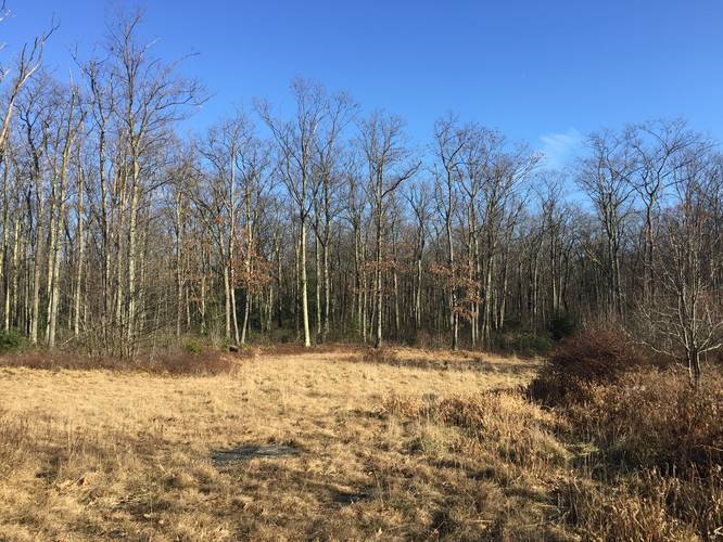
This section of the Hoadley Trail begins at the main trailhead for the Hoadley Trail, located approximately 0.55-miles into the Kinney Hollow Trail. The recording follows the main trail for 0.7-miles before reaching an unmaintained portion of the trail. Here, the recording heads due-north along a well-maintained path. This section of the hike is questionable as to which trail this is - I believe it is not technically part of the Hoadley Trail, but is rather an offshoot that has not been marked by Tioga State Forest's main maps as of December 2019. Regardless, this section of the trail starts to head downhill, gradually, as it makes its way to a mountain ridge located just to the northeast of the turn.
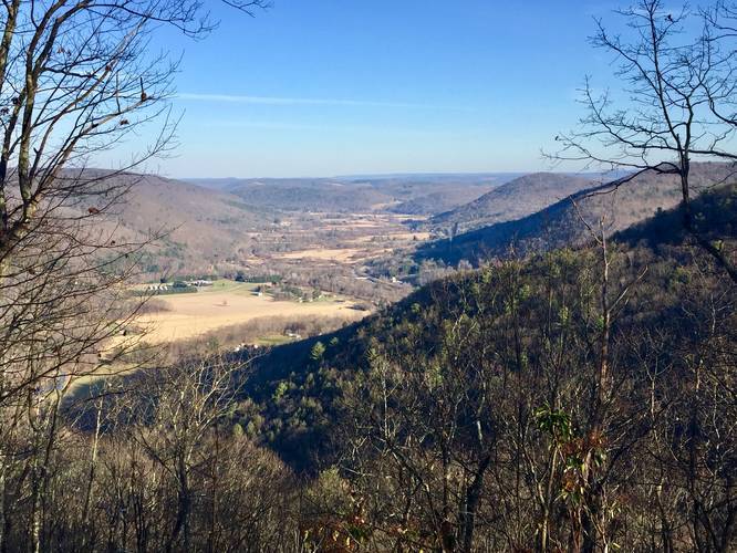
During the cooler months, when no leaves are on the trees, hikers will notice more light shining through the tops of the trees as you make your way toward this mountain ridge. Just before the trail begins to curve to the right - seemingly following the contour of the mountain - is a bushwhacking vista point located about 300-feet off of the trail. Here, hikers can push their way through brush, bushes, and hop over downed-trees to find a small vista point that the park rangers had cut away at some point in time. This vista is not easy to find, but if you use an offline GPS device and download this map to bring on your hike, you should be able to find it.
The recording ends at the vista, so I'm unsure of where the trail continues on to from here; however, hikers can choose to hike back from here to the parking lot. This hike out-and-back is 2.2-miles, excluding the required 1.1-mile out-and-back along the Kinney Hollow Trail.
Vista
The bushwhacking vista has a beautiful view of PA's Route 6 facing east. Below lies the Pine Creek Rail Trail, Marsh Creek, Asaph and the Asaph valley,
Warnings
Bushwhacking: This recording follows approximately half of the Hoadley Trail until it reaches a section that appears to be no longer maintained. At this junction, this recording follows an offshoot of the Hoadley Trail that heads northeast, instead of due-east, out to a bushwhacking vista point. The vista point is located off of the trail and is not easy to find unless the leaves are not on the trees. Inexperienced hikers should not attempt this hike and experienced hikers should use a GPS navigation device while exploring this area.
Rattlesnakes: This vista point was likely cut out to help the native Timber Rattlesnake population thrive. The rattlesnakes need to sunbathe during the day, which these tree cutouts help provide and thus there's likely a den nearby. It's advised to avoid this area between the end of April to early October to reduce chances of encountering a rattlesnake, unless the hiker comes prepared.
Pets
Dogs are allowed if leashed.
Blazes
This trail follows black blazes.
Camping
Backpacking and dispersed/primitive camping is allowed off of this trail; however, I did not see any designated campsites. Please follow the Tioga State Forest rules when backpacking.
Parking
Hikers can find parking at the coordinates provided, which lies at the very end of Goodall Road. The parking lot is large enough to fit a dozen cars or more; however, this is not a very popular spot unless during deer season.
Winter Road Conditions
Tioga State Forest does not maintain this road during the winter. Do not attempt driving on this road without proper equipment including snow tires and/or chains unless the road is clear. High wind storms may also cause trees to fall across the road, making the road impassible. If you plan to visit during the winter, plan accordingly.
This section of the Hoadley Trail begins at the main trailhead for the Hoadley Trail, located approximately 0.55-miles into the Kinney Hollow Trail. The recording follows the main trail for 0.7-miles before reaching an unmaintained portion of the trail. Here, the recording heads due-north along a well-maintained path. This section of the hike is questionable as to which trail this is - I believe it is not technically part of the Hoadley Trail, but is rather an offshoot that has not been marked by Tioga State Forest's main maps as of December 2019. Regardless, this section of the trail starts to head downhill, gradually, as it makes its way to a mountain ridge located just to the northeast of the turn.
During the cooler months, when no leaves are on the trees, hikers will notice more light shining through the tops of the trees as you make your way toward this mountain ridge. Just before the trail begins to curve to the right - seemingly following the contour of the mountain - is a bushwhacking vista point located about 300-feet off of the trail. Here, hikers can push their way through brush, bushes, and hop over downed-trees to find a small vista point that the park rangers had cut away at some point in time. This vista is not easy to find, but if you use an offline GPS device and download this map to bring on your hike, you should be able to find it.
The recording ends at the vista, so I'm unsure of where the trail continues on to from here; however, hikers can choose to hike back from here to the parking lot. This hike out-and-back is 2.2-miles, excluding the required 1.1-mile out-and-back along the Kinney Hollow Trail.
Vista
The bushwhacking vista has a beautiful view of PA's Route 6 facing east. Below lies the Pine Creek Rail Trail, Marsh Creek, Asaph and the Asaph valley,
Warnings
Bushwhacking: This recording follows approximately half of the Hoadley Trail until it reaches a section that appears to be no longer maintained. At this junction, this recording follows an offshoot of the Hoadley Trail that heads northeast, instead of due-east, out to a bushwhacking vista point. The vista point is located off of the trail and is not easy to find unless the leaves are not on the trees. Inexperienced hikers should not attempt this hike and experienced hikers should use a GPS navigation device while exploring this area.
Rattlesnakes: This vista point was likely cut out to help the native Timber Rattlesnake population thrive. The rattlesnakes need to sunbathe during the day, which these tree cutouts help provide and thus there's likely a den nearby. It's advised to avoid this area between the end of April to early October to reduce chances of encountering a rattlesnake, unless the hiker comes prepared.
Pets
Dogs are allowed if leashed.
Blazes
This trail follows black blazes.
Camping
Backpacking and dispersed/primitive camping is allowed off of this trail; however, I did not see any designated campsites. Please follow the Tioga State Forest rules when backpacking.
Parking
Hikers can find parking at the coordinates provided, which lies at the very end of Goodall Road. The parking lot is large enough to fit a dozen cars or more; however, this is not a very popular spot unless during deer season.
Winter Road Conditions
Tioga State Forest does not maintain this road during the winter. Do not attempt driving on this road without proper equipment including snow tires and/or chains unless the road is clear. High wind storms may also cause trees to fall across the road, making the road impassible. If you plan to visit during the winter, plan accordingly.