Loading...

Distance:
1.3 Miles / 2.1 km
Type:
Out-and-Back
Difficulty:
Easy
Time to Hike:
~39 minutes
Features:
PA Wilds
Surface Type:
Dirt
Park:
Loyalsock State Forest
Town:
Forksville, Pennsylvania
Directions:
41.472091, -76.528311
Added:
February 19, 2024
Updated:
February 23, 2024
Loading...
Loading...
114 '

Total Change
132 '

Ascent
132 '

Descent

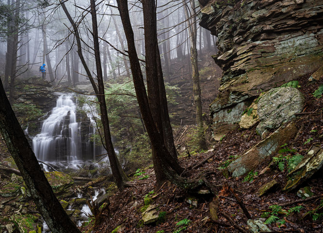
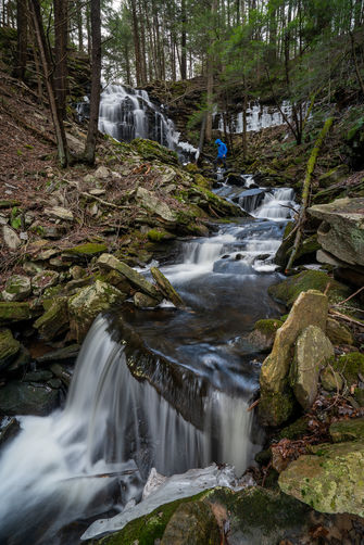
The hike to Tamarack Falls is a somewhat easy off-trail 1.3-mile out-and-back hike to a beautiful waterfall not far from Sones Pond in Loyalsock State Forest near Forksville, Pennsylvania.

Parking:
There is a small pull off on Loyalsock Road at 41.47208, -76.52829, however there are other pull offs nearby if needed, like where the road crosses Tamarack Run at 41.476352, -76.532257. NOTE: Loyalsock Road is a forest road and although the hike could be done year round, the road may become impassable in the winter months.

Hike:
This is an off-trail hike, but follows an old logging grade. From where you park, follow Loyalsock Road and leave the road at 41.47289, -76.52830 where hikers will find a noticeable old grade. Follow this grade about 0.6-miles to Tamarack Falls. Enjoy the waterfall and then retrace your steps back out.  

Explore 51 trails near Forksville, PA
  1. Parking

    41.472091, -76.528311
  2. Main Trailhead

    41.472091, -76.528311
  3. Tamarack Falls

    41.46812, -76.53118
    Tamarack Falls
No community routes found. To add your own hike as a Community Route for this Trail guide, leave a Trip Report with an attached GPX file.

Hazards

Ticks - Lyme Disease More Info (CDC)
Poison Ivy/Oak

Seasons

All

Photo Albums

2 Trip Reports

No Star-Ratings
Write-up by:
Shawng13 user profile picture
1.3 miles / 2.1 km
Trail added
February 19, 2024
Hiked on
February 10, 2024
Updated on
February 23, 2024
3.09 miles / 5.0 km
April 01, 2022
Loved this hike! Parked along Loyalsock Rd where Tamarack Run crosses, then went off-trail staying on east side. Such a beautiful, lush forest area with moss-covered rocks & Pines heading down to the spectacular waterfall with lots of craggy rocks to make it more intricate (water flowing well during a Spring snow squall)! Found an old grade on the way back that is a bit to the east. Then drove down the road to park for the fairly short hike down to Alpine Falls along the LT which was also excellent!
Hiking

Weather Forecast

In Forksville, PA

Explore Hiking Trails

New Hikes

Cottonwood Falls Loop
1.2 Miles
1.9 km
Moderate
Loop
Eternal Flame Falls via Eternal Flame Trail
1.2 Miles
1.9 km
Moderate
Out-and-Back
Sewee Shell Ring Trail
1.1 Miles
1.8 km
Easy
Loop
Tibwin Plantation Trail
1.9 Miles
3.1 km
Easy
Out-and-Back

Before you leave...

MyHikes is an indie web platform aimed to make exploring public trails easier for everyone. The site has no investors and is owned and operated by one person, Dave Miller (Founder & Admin). As the Founder, main contributor, and doer-of-all-things for MyHikes, I share my trips with over-detailed write-ups for fun on a volunteer basis and I believe that public trail information should be available to everyone.

It takes a lot of time ๐Ÿ•ฆ, money ๐Ÿ’ฐ, and effort (including espresso shots โ˜•) to run MyHikes, including hiking , mapping , writing , and publishing new trails with high-quality content... along with building new features, moderating, site maintainance, and app development for iOS and Android . I simply ask that if you find MyHikes' trail guides helpful to please consider becoming a Supporter to help keep the site, iOS, and Android apps available to everyone.

Supporters unlock website and in-app perks with a one-time payment of $25 (you renew) ๐Ÿ˜Ž๐Ÿ‘. Or you can simply make a Donation of your choice without a MyHikes user account. Otherwise, telling your friends about MyHikes is the next-best thing - both quick and free ๐ŸŽ‰

Thanks for visiting MyHikes and have a great hike!๏ธ

Admin user profile picture

Dave Miller
MyHikes Founder & Admin